
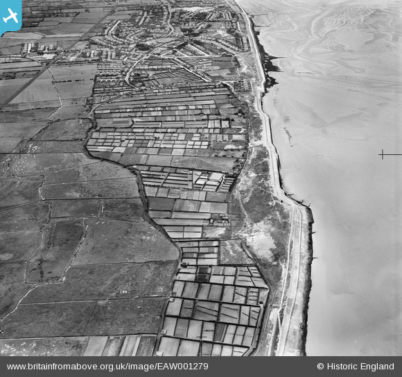
EAW001279 ENGLAND (1946). Allotments at Parkfields alongside East Hoyle Bank, Hoylake, 1946
© Copyright OpenStreetMap contributors and licensed by the OpenStreetMap Foundation. 2026. Cartography is licensed as CC BY-SA.
Details
| Title | [EAW001279] Allotments at Parkfields alongside East Hoyle Bank, Hoylake, 1946 |
| Reference | EAW001279 |
| Date | 24-June-1946 |
| Link | |
| Place name | HOYLAKE |
| Parish | |
| District | |
| Country | ENGLAND |
| Easting / Northing | 324136, 390856 |
| Longitude / Latitude | -3.1413766527139, 53.40879736813 |
| National Grid Reference | SJ241909 |
Pins

Meols Guy |
Wednesday 28th of July 2021 11:53:55 AM | |
|
Meols Guy |
Wednesday 28th of July 2021 11:51:12 AM | |

Matt Aldred edob.mattaldred.com |
Sunday 28th of February 2021 09:34:43 AM | |
|
Matt Aldred edob.mattaldred.com |
Sunday 28th of February 2021 09:34:21 AM | |
|
Matt Aldred edob.mattaldred.com |
Sunday 28th of February 2021 09:33:56 AM | |
|
Matt Aldred edob.mattaldred.com |
Sunday 28th of February 2021 09:33:41 AM | |

Sparky |
Saturday 23rd of September 2017 11:05:49 PM | |
|
Sparky |
Saturday 23rd of September 2017 11:05:05 PM | |
|
Sparky |
Friday 28th of July 2017 09:45:22 PM | |
|
Sparky |
Friday 28th of July 2017 09:44:19 PM | |
|
cptpies |
Monday 6th of January 2014 11:07:25 AM |
User Comment Contributions
WWII Anti Tank Blocks, Hoylake. |
cptpies |
Monday 6th of January 2014 11:07:54 AM |