
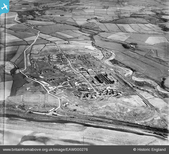
EAW000276 ENGLAND (1946). Royal Ordnance Factory at Sellafield, High Sellafield, 1946
© Copyright OpenStreetMap contributors and licensed by the OpenStreetMap Foundation. 2026. Cartography is licensed as CC BY-SA.
Nearby Images (8)
EAW000276

EAW000273

EAW000272

EAW000274

EAW000275

EAW000279

EAW000278

EAW000277

Details
| Title | [EAW000276] Royal Ordnance Factory at Sellafield, High Sellafield, 1946 |
| Reference | EAW000276 |
| Date | 24-April-1946 |
| Link | |
| Place name | HIGH SELLAFIELD |
| Parish | ST. BRIDGET BECKERMET |
| District | |
| Country | ENGLAND |
| Easting / Northing | 302653, 503658 |
| Longitude / Latitude | -3.5003920128836, 54.418891415008 |
| National Grid Reference | NY027037 |
Pins

Matt Aldred edob.mattaldred.com |
Friday 26th of February 2021 04:50:53 PM | |
|
Matt Aldred edob.mattaldred.com |
Friday 26th of February 2021 04:50:42 PM | |
|
Matt Aldred edob.mattaldred.com |
Friday 26th of February 2021 04:50:31 PM | |
|
Matt Aldred edob.mattaldred.com |
Friday 26th of February 2021 04:43:29 PM | |
|
Matt Aldred edob.mattaldred.com |
Friday 26th of February 2021 04:42:16 PM | |

redmist |
Sunday 7th of February 2021 10:21:34 PM | |
|
redmist |
Sunday 7th of February 2021 10:21:18 PM | |
|
redmist |
Sunday 7th of February 2021 10:20:48 PM |