
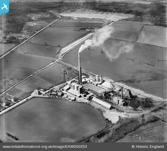
EAW000253 ENGLAND (1946). Portland Cement Works, Ketton, 1946
© Copyright OpenStreetMap contributors and licensed by the OpenStreetMap Foundation. 2026. Cartography is licensed as CC BY-SA.
Nearby Images (19)
EAW000253

EAW000252

EPW043956

EPW028845

EPW028847

EPW028842

EAW000250

EPW028846

EPW028844

EPW043960

EPW028848

EAW000251

EPW028843

EPW043959

EAW000249

EPW043961

EPW043962

EPW043957

EAW000254

Details
| Title | [EAW000253] Portland Cement Works, Ketton, 1946 |
| Reference | EAW000253 |
| Date | 15-April-1946 |
| Link | |
| Place name | KETTON |
| Parish | KETTON |
| District | |
| Country | ENGLAND |
| Easting / Northing | 498409, 305529 |
| Longitude / Latitude | -0.54557010690891, 52.638220883275 |
| National Grid Reference | SK984055 |
Pins

Sparky |
Wednesday 27th of September 2017 09:45:11 PM | |

Dylan Moore |
Friday 20th of June 2014 09:00:59 PM | |
|
Dylan Moore |
Friday 20th of June 2014 09:00:25 PM | |
|
Dylan Moore |
Thursday 22nd of August 2013 11:40:27 PM |
User Comment Contributions
This image appears in Peter del Strother's book "75 Years of Ketton Cement. Images 249-253 were commissioned from Aerofilms by Ketton Portland Cement and are part of the Ketton Archive. Similar sets were commissioned in 1929 and 1934. The other plants operated by F L Smidth also commissioned aerial images at key times in their history - typically after extensions to the plant. |
Dylan Moore |
Friday 20th of June 2014 09:07:35 PM |