
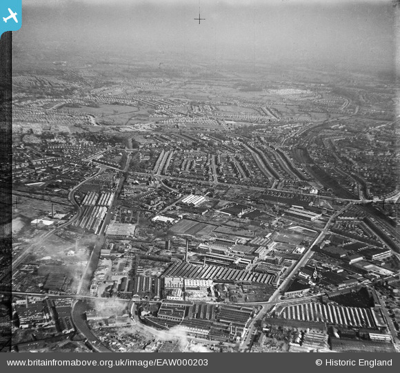
EAW000203 ENGLAND (1946). The Bakelite Works and the residential area at Stockfield, Tyseley, from the north-west, 1946. This image has been produced from a damaged negative.
© Copyright OpenStreetMap contributors and licensed by the OpenStreetMap Foundation. 2026. Cartography is licensed as CC BY-SA.
Nearby Images (46)
EAW000203

EPW044576

EAW000195

EPW044568

EPW044569

EAW000197

EAW000202

EPW044574

EPW044570

EPW044575

EAW000200

EPW044573

EAW000201

EAW000198

EAW000196

EPW044571

EAW041909

EAW000199

EAW041911

EAW000194

EPW044572

EAW042221

EAW042220

EAW041907

EAW042228

EAW042223

EAW042222

EAW041912

EAW041906

EAW042224

EAW041905

EAW042229

EAW041910

EPW061227

EAW041908

EAW042225

EAW042227

EPW047186

EAW029658
 and environs, Tyseley, 1950. This image has been produced from a print marked by Aerofilms Ltd for photo editing.")
EAW029663
 and environs, Tyseley, 1950. This image has been produced from a print marked by Aerofilms Ltd for photo editing.")
EAW029657
, Tyseley, 1950. This image has been produced from a print marked by Aerofilms Ltd for photo editing.")
EAW029665
 and environs, Tyseley, 1950. This image has been produced from a print marked by Aerofilms Ltd for photo editing.")
EPW047185

EAW029659
 and environs, Tyseley, 1950. This image has been produced from a print marked by Aerofilms Ltd for photo editing.")
EAW029661
 and environs, Tyseley, 1950. This image has been produced from a print marked by Aerofilms Ltd for photo editing.")
EAW029664
 and environs, Tyseley, 1950. This image has been produced from a print marked by Aerofilms Ltd for photo editing.")
Details
| Title | [EAW000203] The Bakelite Works and the residential area at Stockfield, Tyseley, from the north-west, 1946. This image has been produced from a damaged negative. |
| Reference | EAW000203 |
| Date | 16-April-1946 |
| Link | |
| Place name | TYSELEY |
| Parish | |
| District | |
| Country | ENGLAND |
| Easting / Northing | 411219, 284467 |
| Longitude / Latitude | -1.8348731183072, 52.457665839249 |
| National Grid Reference | SP112845 |
Pins

Warrick |
Tuesday 11th of August 2020 02:23:48 PM | |

Sparky |
Wednesday 27th of September 2017 10:09:21 PM | |
|
Sparky |
Wednesday 27th of September 2017 10:07:12 PM | |

Class31 |
Tuesday 22nd of October 2013 12:03:20 PM | |
|
Class31 |
Tuesday 22nd of October 2013 11:56:03 AM | |
|
Class31 |
Tuesday 22nd of October 2013 11:47:13 AM | |
|
disco |
Thursday 17th of October 2013 01:31:45 PM |