
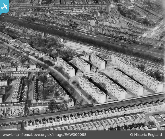
EAW000098 ENGLAND (1946). Flats at Herne Hill, Brixton, 1946
© Copyright OpenStreetMap contributors and licensed by the OpenStreetMap Foundation. 2026. Cartography is licensed as CC BY-SA.
Nearby Images (5)
EAW000098

EAW000096

EAW000097

EPW060447

EAW000095

Details
| Title | [EAW000098] Flats at Herne Hill, Brixton, 1946 |
| Reference | EAW000098 |
| Date | 1-April-1946 |
| Link | |
| Place name | BRIXTON |
| Parish | |
| District | |
| Country | ENGLAND |
| Easting / Northing | 531711, 175072 |
| Longitude / Latitude | -0.10394540266232, 51.458792907916 |
| National Grid Reference | TQ317751 |
Pins

cal |
Monday 10th of June 2019 01:57:34 AM | |
|
cal |
Monday 10th of June 2019 01:57:06 AM | |
|
cal |
Monday 10th of June 2019 01:56:09 AM | |
|
cal |
Monday 10th of June 2019 01:55:19 AM | |
|
cal |
Monday 10th of June 2019 01:54:54 AM | |
|
cal |
Monday 10th of June 2019 01:54:21 AM | |
|
cal |
Monday 10th of June 2019 01:53:45 AM | |
|
cal |
Monday 10th of June 2019 01:52:58 AM | |
|
cal |
Monday 10th of June 2019 01:52:25 AM | |
|
cal |
Monday 10th of June 2019 01:51:43 AM | |
|
cal |
Monday 10th of June 2019 01:51:00 AM | |
|
brianbeckett |
Saturday 20th of September 2014 09:41:36 PM |