
Groups
Britain Under Construction
About the group Britain has changed since the early days of Aerofilms. Help us collect images of all kinds of building sites - do you know what it looks like today?
Created 11 May 2012

John Ellis |
||
|
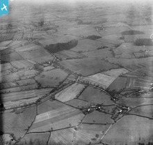
This picture, looking almost due north, shows the area between the Altrincham - Stockport road and the Liverpool-Warrington-Stockport railway line as it was in 1927, before any new housing had taken place, and before the Cheshire civil parish of Baguley had been incorporated into Manchester.
|
John Ellis |
|
|
Given the beautiful summer weather, I spotted this building under construction just opposite the beach near Morecambe promenade Railway Station. Exploring the images of Morecambe more closely, I find it fascinating to spot industrial sites and a more leisurely seaside in close vicinity. The question here is therefore: what will this building be used for?
|
Sandra Brauer |
|
|
I think it is the Empire Arcade, my wife remembers it, hope this helps
|
wadey |
|
|
From the wondeful Morecambe and Heysham Past and Present Facebook Group it is Fahy's garage which is under construction
|
wadey |
|
|
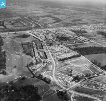
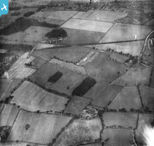
Despite post-war shortages of materials and restrictions on building, work on the Wythenshawe estate housing project quickly resumed after the end of the war. At its top right corner, this 1946 photograph catches the laying out of roads (Floatshall and Bowland Roads and their sideshoots) in readiness for new housing on Baguley farmland between Floats Road and Hall Lane, across the railway from the pre-war Royal Oak estate; and, further north, the construction of temporary prefab bungalows on the land of Sycamore Farm, between the A560 Altrincham Road and the wooded western fringes of Wythenshawe Park. Image EPW017426 shows much of the same tract of country as it was twenty years earlier, before any significant development had taken place.
The post-war council houses that would be built on these new roads perhaps lacked the charm and variety in design of Barry Parker's pre-war estates, but the policy of tree-planting and creating abundant green space was continued. Amenities, however, were for long in distinctly short supply: other than small local shopping parades, pubs, clubs and churches, there was little to break up or give shape to the miles of remarkably similar and rather featureless streets and houses. And the absence of good rail links and Manchester Corporation Transport's almost total monopoly of local bus services meant that it was impossible to travel conveniently and easily by public transport to anywhere other than central Manchester - even though that involved a twenty mile round trip from Wythenshawe's southernmost estates. But the environment was at least open, pleasant, and considerably cleaner than the packed terraced housing of the 19th century inner-city suburbs which it replaced, and the Wythenshawe estate was pretty much complete by the time the 1960s fashion for municipal architectural brutalism came in. However Wythenshawe hasn't been entirely spared. In particular, parts of the industrial areas have been developed and redeveloped several times, not always with attractive results. And Southmoor Road - which roughly follows the course of the now vanished northern section of Floats Road around Floats Hall on this shot - is as hideous a bit of modern roadscape as you could find anywhere, with charmless geometrical industrial units on its western side and, currently under construction on the former grass verges of its eastern side, the bleak steel and concrete of the Metrolink tramway to the airport. |
John Ellis |
|
|
The river Mersey and its floodplain were always historically a barrier between Lancashire and Cheshire, and crossing places - for long often fords and ferryboats rather than bridges, especially on the middle and lower reaches of the river - were few and far between.
For centuries that had mattered more to merchants and soldiers passing through than it had to local people, who usually had neither the opportunity nor the incentive to travel far. Even in the early twentieth century, the inhabitants of the scattered farms, cottages and hamlets of Northen Etchells would look to Stockport as their market town, while those in Baguley looked to Altrincham. Perhaps only Northenden village, benefiting from the Palatine Road bridge and a tram link northward, gravitated to some extent to Manchester as a centre. That of course wasn't how Manchester's city fathers viewed matters when, in the 1920s, they began to contemplate building new public housing in the adjacent Cheshire countryside to replace their inner-city slums. At that time there was only one bridge linking Manchester with the tract of countryside it coveted: the 19th century Palatine Road, which just over eighty years before had made redundant both the ford and the ferry still commemorated by the names of Northenden's Ford Lane and Boat Lane. Nor was it likely to fit the preferences of the folk who would eventually come to live in the new houses, who were overwhelmingly inner-city Manchester folk who long continued to gravitate back to Manchester for their shopping and their social life. Hence Manchester City Council's decision to extend Princess Road, a straight modern "expressway" already built from Moss Side through residual open country between Cholton and Withington as far as West Didsbury. This new road would now, the councillors decided, be driven on southwards, bridging the Mersey and passing the western fringe of Northenden, to link up with the Stockport-Altrincham road - the one main road already running east to west through the Wythenshawe estate area - so providing the new estate with a quick and relatively uncongested route into the city centre. When completed it was classified as the A5103. The Northenden section of Princess Parkway - south of Kenworthy Lane - was deliberately laid out on both sides with enormously wide grassy perimeters, abundantly planted with trees and large shrubs and criss-crossed by a choice of tarmac footways. This reflected the style of Barry Parker, the town planner entrusted to lead the Wythenshawe estate project, who was a devotee of the "garden city" principles of urban development which came to the fore in the early twentieth century; his estates were very varied in house and ground plan design, with generous provision of green space and trees. He even managed to preserve almost all of the woods, spinneys and copses which had speckled the open farmland and these still mostly survive today. Unlike Princess Parkway's serene parkland surroundings, which have been much diminished by the A5103's integration into the later twentieth century motorway network, with space-devouring slip roads replacing the original road's use of large roundabouts at its major intersections. But given the modern preoccupation with crime - not to mention Wythenshawe's later reputation in that respect! - perhaps the hundreds of yards of secluded pathway, often diving behind dense shrubberies, have come to be less valued than they were in the early days back in the more innocent and less suspicious 1930s?! |
John Ellis |
|
|
Taken at the same time as the previous two shots, this picture shows the first stages of construction of what became the largest of the pre-war Manchester public housing developments on Wythenshawe estate land. By the outbreak of the war, most of the open country between the Northen Etchells township hamlets of Sharston Green in the north and Brownley Green in the south had been built on.
This early development was on land on and adjacent to Lower Haveley Hey, the site of which lies almost exactly under the circle on Haveley Road. At the top of the picture, and with the camera looking almost due south, Haveley Hey (Cook's Farm) is the one relic of the old rural scene still remaining on this shot. This housing estate ultimately got the name of "Benchill", after a large farm of that name (Benchall on very old maps) a couple of fields north-east of Lower Haveley Hey. The countryside in this area before development can be seen - though from a rather higher altitude and on a rather cloudy day - in image EPW017393, taken in April 1927. There's a link to this shot on the left of the image record. |
John Ellis |
|
|
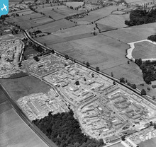
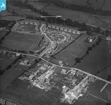
While Manchester City Council developed only one new housing site in Baguley prior to the second world war, there was considerably more development in neighbouring Northenden and Northen Etchells townships. This shot shows housing under construction at Northen Moor, to the west of Northenden village, at the same time as the houses on the Royal Oak estate in Baguley were being built half a mile or so to the south on the other side of Wythenshawe Park.
To the north-west and at the top of the picture new housing development in Sale Moor can be seen. Almost all of the open country shown on this picture and the previous one had been built over by 1960. |
John Ellis |
|
|
Manchester City Council acquired the estate of Wythenshawe Hall (which stands just beyond the top right-hand corner of this photograph) in 1926. The intention was to develop this almost completely rural area south of the Mersey - one of a very few open agricultural areas still remaining close to the city boundary - with public housing to enable slum clearance around the city centre.
The local Bucklow Rural District Council having experienced difficulty in providing public services for the first stages of the new housing development, Manchester City Council was able in 1931 to engineer the transference of the three civil parishes of Northenden, Northen Etchells and Baguley from Bucklow Rural District and Cheshire County into Manchester itself. Historically, Northenden and Northen Etchells were the two townships which comprised Northenden parish, while Baguley was the easternmost township of Bowdon parish, just south of the old market town of Altrincham, which covered a large area around that town. This picture shows the construction of the first Manchester council houses to be built in the Baguley township, on land east and south-east of the village, in the fields which lay between the Altrincham-Stockport Road (A560) and the Liverpool-Altrincham-Stockport railway line a little to the south of it. The estate became known as "the Royal Oak", taking its name from the old pub on the Stockport-Altrincham Road just at the eastern end of the bottom village, which (with reasonable but not total certainty!) I've marked with a pin on the map. My certainty's not total because the old pub was completely demolished and replaced with a larger modern one in characteristic '30s style, which I do remember very well from schooldays. Like so many pubs, I believe that it closed some time around the end of the last century and the site has been redeveloped. The aerial photograph shows the entire estate in the early stages of construction, looking broadly west in the direction of Altrincham. The fields, farms and market gardens around the bottom (shoeing forge/Congregational church) and the top (school and Gardener's Arms pub) ends of the village are (only just in the case of the latter) visible at the top of the picture. |
John Ellis |
|
|
By the time this London County Council housing estate had been largely completed at the beginning of Coronation Year in 1953, 17,000 folk had been re-housed, mostly from the bombed-out slums in north and east London, on Green Belt land between the GLC boundary and Watford, in South-West Herts.
|

John Swain |
|
|
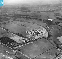
Merchant Taylors' School, Sandy Lodge, Northwood, Middlesex, was founded in 1561 and was located in the City of London (Suffolk Lane) until it moved to Charterhouse Square, Finsbury, in 1875. The need for more space led to its re-location at Sandy Lodge, a greenfield site of 256 acres, close to the Metropolitan Railway line and handily situated between Watford and Rickmansworth, on the north-west side of Greater London. This photograph was taken at the completion of the new school, which was officially opened on June 12, 1933.
Between the River Colne and the LMS Rickmansworth Branch Railway line, in the right background, is the familiar white, modern (Art Deco front elevation) Asbestos Works on Tolpits Lane, which was to play a large part in the construction of Britain for the next half-century. On the right-hand margin of the picture is one of several wet-pits in the area, where the extraction of vast amounts of river gravel was used for the construction of Metroland-type suburbia, including Wembley Stadium (1923) and the British Empire Exhibition (1924/25). The early stage of the formation of Hampermill Lake (1938) is depicted here and a second feature was created by 1960. The medium-sized, independent school continues to thrive eighty years later, but the factory was closed in 1985. |
John Swain |
|
|
Becontree Estate in Essex was built by the London County Council between 1921 and 1934 on four square miles of flat land, over half in Dagenham, a third in Barking and under a sixth in Ilford. This huge housing estate provided nearly 27,000 homes for 90,000 people, and was reckoned to be the largest of its kind in pre-war Europe.
|
John Swain |
|
|
The Manor Estate in Sheffield was built at a time when the city was the largest in Yorkshire and the fifth largest in England (512,000 in the 1931 census). Situated on the south-east side of Sheffield, this estate contained over 30,000 people at its peak in the 1930s and was one of many interwar council housing developments attempting to alleviate the poverty of the inner city slums. Twenty years ago, this writer participated in a Geographical Association excursion around Sheffield, which included a brief tour of this estate, when the population had fallen below 10,000 and several of the houses had already been demolished, barely sixty years after their construction.
|
John Swain |
|
|
Oops, the reference to Prestwich should have read Crumpsall, better get the correction in before any eagle-eyed member spots the error!
|
OldiePhil |
|
|
Hi OldiePhil,
thanks for your post. I would say that the fact that your house will be build a few years later in the same spot is not an excuse but a very good reason to post the image! Maybe we should open a new category in this group to collect images which show the building sites where the houses of users will be or are being built ... I can't compete, unfortunately, the house I currently live in was already built when the picture was taken in 1920. |
Sandra Brauer |
|

|
OldiePhil |
|
|
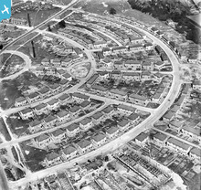
Thanks for the tip, BruceR! Here's the image. I find it shows particularly well how people still prefer the direct way to all the planned rectangular road works - you can see the paths they made as well as the actual streets!
|
Sandra Brauer |
|
|
Indeed, fine example of the human temperament and the planners art not fitting too well. There was much further development, including completing the elongated roundabout seen in the centre of the picture. It is evident in modern aerial pictures of Letchworth, although the "cutting the corner" footpaths have gone.
|

Maurice |
|
|
There are a couple of planned factory towns on the Wirral. Port Sunlight is the best known, it still stands next to the Lever Brothers factory, now Unilever. I think you can just see it in the top right of this picture.
http://www.britainfromabove.org.uk/image/epw025167 Also Prices Candles had a workers village, which can be seen here. .. http://www.britainfromabove.org.uk/image/epw021620 |
BruceR |
|
|
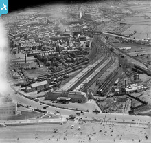
This is another image that I find very interesting for this category... If you click on 'see image record', you will find that lots of people have already pinned the image, noting all the different industries that rapidly grew before the beginning of WW2 in this place - quite obviously after this image was taken!
I do find the concept of Garden Cities generally quite interesting but don't personally know a lot about them - has anybody come across collection images of other planned cities across the country yet? |
Sandra Brauer |
|
|
There are a few of Letchworth like this one ..
epw013190 |
BruceR |
|
|
Sir Ebenezer Howard (1850 –1928) is known for his publication Garden Cities of To-morrow (1898), the description of a utopian city in which people live harmoniously together with nature.
This resulted in Welwyn and Letchworth garden cities near London. The ideas were also used in relation developments, such as Bournville by the Cadburys in Birmingham and the Rowntrees in York. I have annotated EPW001104 Bournville. The concept of the garden city is in contrast to the planned city. There are numerous examples of geometric developments in the Britain from Above collection, for example Billingham EPW032188. However, these do not always carry with them the philosophical approach to the relationship between those dwelling in the garden city and the landscape. For example, Cadbury insisted that the housing provided for workers in the chocolate factory should include a garden with an apple tree, thus encouraging a productive relationship with the land. Indeed, many of the Bournville’s houses might be described as cottages, reminiscent of those built on the more well-found English country estates from the shire countries. The garden city was attempting to bring the country to the town. |
Maurice |
|
|
A better view of Liverpool's Anglican Cathedral under construction.
|
BruceR |
|
|
Look at the top right of the picture to see Liverpool's Anglican Cathedral under construction.
|
BruceR |
|
|
MacFalane Lang was one of the companies that became United Biscuits, the company that makes McVities and a number of other well known brands.
For a while this was the site of the HQ. The site is now occupied by Sky News and a Tesco superstore. |
BruceR |
|
|
The Aerofilms Collection has many photos showing housing estates under construction. But we don't know where this one is!
|
Whittocks |
|
|
Hi Whittocks
I can now confirm that I have identified this photograph as the Pinner Road area of Northwood in Metroland. Please see the listing for full details. |

Class31 |
|
|
Hi Class31, thanks for helping us with identifying this picture! Your new identification will have gone through to our Cataloguing Team who will be getting back to you in due course. I did like the sound of that Portuguese Cafe you mentioned, too ...
|
Sandra Brauer |
|
|
I was really interested to discover this site and especially the images annotated by John Ellis.
I grew up in a house rented by my parents from the Lamb family of Baguley. It was a market garden business. I can remember the long heated greenhouses of tomatoes, bedding plants and beautiful crysanthemums grown for sale. Our house was about 250 years old. It had an attached wash-house with privy, a pebbled yard in front and a barn opposite where the tractor was kept. There were the old horse harnesses on the wall of the barn. The Cottage, Butcher Lane was demolished in the late 1960s I think. |
Cath |
|
|
Interesting to read your recollections, Cath. I effectively moved away in 1964, when I went off to university and life, and with it my focus of interest, changed radically. I was away for almost exactly twenty years, and when I came back, my childhood and teenage haunts had of course changed radically too.
But up to autumn 1964 I used to cycle regularly round and about the Baguley/Timperley border area, as it was the nearest bit of open countryside still surviving close to where I grew up. I remember Butcher Lane and Sandy Lane pretty well: the tree-shrouded bit north of the railway line, the railway bridge itself which was still cobbled, and then the drop down to Shady Lane at the south end, with little Butcher Farm on the east side near the junction. But I can't recall "the Cottage" - was it the house at the end of the track, opposite Sandy Lane? I recall long greenhouses close by there, in the triangular block of land east of Baguley railway station which was bounded by Butcher Lane, Shady Lane and Altrincham Road; and long lines of lettuces in the early summer grown in the open. And the rhubarb field between the station forecourt and Brooks Drive ... |
John Ellis |
|
|
Thought it might be worth joining this group, having spotted Sandra Brauer's contribution - I grew up on the fringes of Wythenshawe, and am old enough to remember some of the last open fields, farms and market gardens - and when you could still catch passenger trains from Northenden and Baguley stations.
Over the last few weeks I've annotated the various shots of Wythenshawe (including what's now the airport) and some immediately surrounding areas with the names of roads, farms, woods, features, &c., many of which are now long vanished; there's been such radical change since the late 1920s that people familiar with the area as it is now might struggle to recognize anything. A bit like doing a jig-saw, but way more fun ... |
John Ellis |
|
|
Well, welcome to the group, John Ellis! You are right, the group is also about how the quiet countryside changed into a Britain we are more familiar with today. It's great to hear about your memories of the rural character of the area you grew up in - I assume you spent a lot more time roaming fields and meadows when you were younger? And did they used to sell food from the farms, just like they seem to do everywhere nowadays? Pleased to hear that you have enjoyed using the website so far!
|
Sandra Brauer |
|
|
No - farm gate sales were less common back in the late '50s and early '60s, though I do remember a couple of farms in Dunham Massey, west of Altrincham (not an area caught on these photographs) which sold potatoes in bulk.
Nothing so glossy as farm shops - you saw the sign at the farm entrance, drove in the yard, and just knocked on the back door. And you bought them in 56lb sacks, like it or lump it - no small size option. But they were cheap, in comparison with shop prices. Rather more common at that time in the market gardens which predominated over arable or dairy farming in the rural pockets in by then mainly urbanized areas like Timperley and Baguley was the sale, in spring and early summer, of bedding plants to surburbanites keen on having a colourful garden. Quite a lot of nurserymen went in for that. Along with the sale of rhubarb (known humorously as "Baguley beef") which grew really well locally; there's even a variety of rhubarb called "Timperley Early" because it was developed locally. Every market garden had a rhubarb field, or at least a patch alongside the long straight lines of lettuces and cabbages. |
John Ellis |
|
|
Bringing materials to construction sites…. These pictures offer an illustration of a common practice in the 1920s. Build a new suburban railway through the country around London and then use it to bring in the materials to build houses for people who will become the customers of the new railway.
EPW016517 To the right (east) of the railway may been seen a system of temporary sidings that carried building materials onto the new housing estate. In the lower right-hand corner of the picture is a string of open wagons, the light colour suggesting that they might be carrying sand or gravel. While one line connects to the railway another is curving off into the estate. The full extent of these sidings beyond the edge of the picture can be seen at the top of EPW017380 EPW017379 This picture includes a feature to be found on large building sites at this time - as system of railway sidings bring materials very close to the construction of the houses. Clearly it was easier to lay railway tracks directly onto the ground to bring in materials than to try and move them over the site in small motor vehicles. The sidings can be seen between rows of materials and carry a number of groups of wagons. There are other views in this set of pictures that illustrate the extent of the system. |
Maurice |
|
|
This photograph captures not only our famous Terry's factory under construction, but the nearby church of St Chad on Campleshon Road.
|
YorkStories |
|
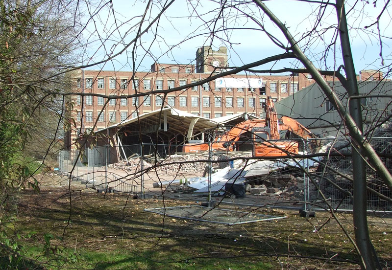
... and this year parts of the factory were being demolished (not the handsome iconic buildings, which are being retained) - photo taken on 29 March 2012
|
YorkStories |
|
|
Thanks for this contribution, YorkStories! It's somehow really sad but also admittedly fascinating to follow up like this on the lifespan of a building. Do you happen to know what is planned to replace these buildings after their 86 years in the service of producing chocolate?
|
Sandra Brauer |
|
|
The only "unlocated" shot in the particular flight in April 1927 which covered the localities south of Manchester. The camera takes in a view to the east, with the then hamlet of Poundswick (it was just west of the present Wythenshawe Civic Centre) in the foreground, Brownley Green in the middle distance, Crossacres beyond, and with the line of Styal Road at the top of the photograph.
|
John Ellis |
|
|
The picture shows the untouched countryside before a housing estate was developed which nowadays sits in a mostly urbanised area south of Manchester.
|
Sandra Brauer |
|

This is an image of how the Benchill area appears today.
|
Sandra Brauer |
|
|
It looked prettier back then!
|
John Ellis |
|
|
A good example of 'recycling' temporary structures ... find out more from the Wiki entry of this image!
|
Sandra Brauer |
|
|
Whittocks |
||
|
More people, more houses, more plumbing, more sewage...
|
Whittocks |
|
|
The detail on this photo is amazing. There are houses at every stage, from mere foundations to just completed. Zoom in to look at the scaffolding!
|
Whittocks |
|
|
These new houses are going up in Ilkley. All of the fields in the photo were eventually built on.
|
Whittocks |
|
|
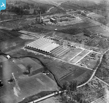
There aren't any photos of building sites in this group yet - here a very detailed image of the construction of quite a big hall for the film studios!
|
Sandra Brauer |
|
|
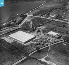
The main focus of the photo are the building sites. However, if you look more closely, you can identify people playing tennis on the numerous courts in the park!
|
Sandra Brauer |


see image record