
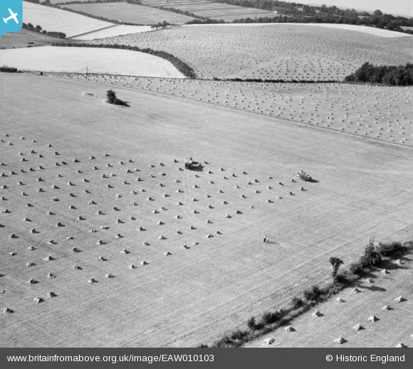
eaw010103 ENGLAND (1947) [Unlocated]. UNLOCATED
© Copyright OpenStreetMap contributors and licensed by the OpenStreetMap Foundation. 2025. Cartography is licensed as CC BY-SA.
Nearby Images (48)
EPW000143

EPW000667

EPW005260

EPW006389
, 1921")
EPW007181

EPW015853

EPW015854

EPW015855

EPW016012

EPW016510

EPW016641

EPW017028

EPW017029

EPW017136

SAW003585

SAW003586

SAW009337

SAW009800

SAW009801

SAW009802

SAW010734

SAW014737

SAW017926

SAW017927

SAW032504

SPW020275

SPW020280

SPW020281

SPW020284

SPW020632

SPW020633

SPW027083

SPW049776

SPW049777

SPW049779

SPW049783

SPW049791

SPW049798

SPW049801

SPW049827

SPW049828

SPW049831

SPW049832

SPW049834

SPW049948

SPW049949

SPW051009

SPW062638

Details
| Title | [EAW010103] UNLOCATED |
| Reference | EAW010103 |
| Date | 11-August-1947 |
| Link | |
| Place name | |
| Parish | |
| District | |
| Country | ENGLAND |
| Easting / Northing | 0, 0 |
| Longitude / Latitude | -7.556448482059, 49.766185796754 |
| National Grid Reference | SV000000 |
Pins
 Class31 |
Wednesday 3rd of September 2014 10:03:38 AM | |
Class31 |
Wednesday 3rd of September 2014 09:48:33 AM | |
Class31 |
Wednesday 3rd of September 2014 08:42:47 AM | |
 TomRobin |
Sunday 8th of June 2014 11:06:07 AM | |
TomRobin |
Sunday 8th of June 2014 11:05:34 AM | |
 Maurice |
Wednesday 20th of November 2013 04:21:00 PM | |
Maurice |
Wednesday 20th of November 2013 04:20:27 PM | |
Not sure these are that 'flat'. As the horizon (top-right) slants to the right, these fields may actually be sloping down to the left slightly. |
nkingdon |
Sunday 24th of November 2013 12:12:32 AM |
This is the only area of the image where I have any concerns about what I can see in the photograph and what I can identify on the map. On the maps which are available I see large fields in this area but in the photo I see an area which is divided up into smaller enclosures. I think that the incompatible structures and divisions may be temporary but I shall try to research further. |
Class31 |
Wednesday 3rd of September 2014 08:55:27 AM |
nkingdon |
Wednesday 13th of November 2013 10:53:18 PM | |
Don't get too excited - rationing was still in place, although it was often easier in the countryside to find a good meal! |
Maurice |
Wednesday 20th of November 2013 04:22:21 PM |
nkingdon |
Wednesday 13th of November 2013 10:52:03 PM | |
I've been having a good look at Barwythe Hall near Studham but I can't get it to fit. |
Class31 |
Wednesday 12th of March 2014 10:04:43 AM |
Amersfort |
TomRobin |
Sunday 8th of June 2014 11:07:55 AM |
I've had another good look just at this house and I have to say that I am almost 100% certain that this is Amersfort Hall near Berkhamsted. Comparing the building in the photograph with the image on Google Earth the main house is identical. In the original photo there are two outbuildings which have now gone but in my view this is Amersfort as identified by Tom Robin. In detail there are five attic windows along the main roof and an attic window in the each of the extensions at each end of the long roof. There are two attic windows along the left hand roof. In my view there is too much that is right for this to be anywhere else. |
Class31 |
Wednesday 3rd of September 2014 08:35:29 AM |
User Comment Contributions
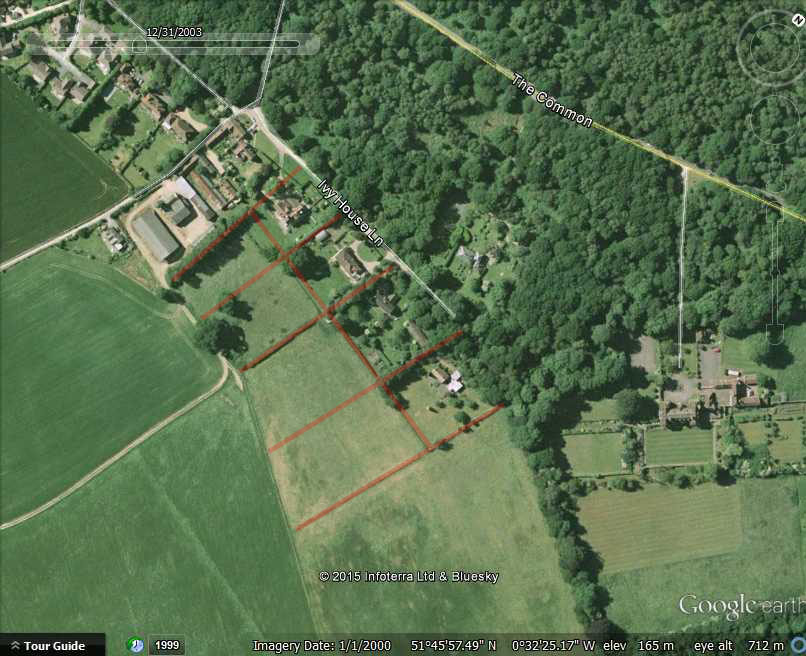 The location given by TomRobin is in my opinion correct, the biggest single problem in making the field boundaries fit is the fact that there are such massive elevation changes across the picture, if you drop into street view on bullbeggers lane just to the west of bullbeggers wood you will see what I mean. The track across the field in the forground with the van on the corner can clearly be seen on google earth, particularly on the 12/2003 image, and Class 31s break in the corn is also the track, however the field boundaries on that hill side have been removed, though their traces can still be seen in some google earth images. As for the missing small enclosures in the background I attach a image to show where I think they are |
Dave Brunt |
Thursday 15th of January 2015 07:25:27 PM |
I even tried using a mirror but I don't think that it has been reverse printed. |
Class31 |
Wednesday 3rd of September 2014 10:52:41 AM |
EAW014223 may cover part of the area in this photograph. |
Class31 |
Wednesday 3rd of September 2014 10:31:18 AM |
Looking North West |
TomRobin |
Monday 11th of August 2014 03:09:50 PM |
Well done TomRobin. Persistence pays off. This photo is on display at the exhibition at the RAF Museum and we now know where it is located. |
Class31 |
Thursday 24th of July 2014 07:59:05 PM |
Hi TomRobin, Regrettably I need some more clarity on this image's location. Are you suggesting that the grid pattern in the fields at the very top centre of the image represents The Pheasantries, or Balshaw Nurseries? I'm afraid I can't make the field boundaries fit well-enough with the wooded areas (especially Gutteridge Wood) that have been and still are in this area. Yours, Katy Britain from Above Cataloguing Team Leader |
Katy Whitaker |
Monday 11th of August 2014 03:09:50 PM |
Maybe Amersfort near Potten End |
TomRobin |
Sunday 8th of June 2014 11:02:11 AM |
Judging by the sun, we are looking west. So with the rising land to the south it maybe the chilterns escarpment. |
TomRobin |
Sunday 8th of June 2014 08:47:31 AM |
At the Britain From Above Exhibition at the RAF Museum a little more information is available about this photo. We are told that this photo is shown in the original Aerofilms records as near Berkhamstead (sic) There is a possibility that this information may narrow down the area to search. |
Class31 |
Wednesday 12th of March 2014 10:43:09 AM |
EAW010103 is at Tring and EAW010105 is at Wednesfield. Assuming this shot was on the same flight as those, then the location may be in Buckinghamshire or Northamptonshire - or possibly - Warwickshire |
MB |
Wednesday 20th of November 2013 12:43:12 PM |