
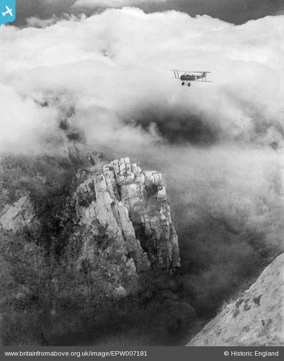
EPW007181 ENGLAND (1921) [Unlocated]. UNLOCATED
© Copyright OpenStreetMap contributors and licensed by the OpenStreetMap Foundation. 2024. Cartography is licensed as CC BY-SA.
Nearby Images (48)
EPW000143

EPW000667

EPW005260

EPW006389
, 1921")
EPW007181

EPW015853

EPW015854

EPW015855

EPW016012

EPW016510

EPW016641

EPW017028

EPW017029

EPW017136

SAW003585

SAW003586

SAW009337

SAW009800

SAW009801

SAW009802

SAW010734

SAW014737

SAW017926

SAW017927

SAW032504

SPW020275

SPW020280

SPW020281

SPW020284

SPW020632

SPW020633

SPW027083

SPW049776

SPW049777

SPW049779

SPW049783

SPW049791

SPW049798

SPW049801

SPW049827

SPW049828

SPW049831

SPW049832

SPW049834

SPW049948

SPW049949

SPW051009

SPW062638

Details
| Title | [EPW007181] UNLOCATED |
| Reference | EPW007181 |
| Date | 6-October-1921 |
| Link | |
| Place name | |
| Parish | |
| District | |
| Country | ENGLAND |
| Easting / Northing | 0, 0 |
| Longitude / Latitude | -7.556448482059, 49.766185796754 |
| National Grid Reference | SV000000 |
Pins
 Gerald Maull |
Wednesday 13th of August 2014 05:41:38 PM | |
Sandy |
Sunday 8th of July 2012 01:35:23 PM | |
Martroy |
Thursday 28th of June 2012 10:32:10 PM |
User Comment Contributions
Hullo everyone! Just to let you know that this negative what not recorded in the Aerofilms Ltd Register (the reference number was written on the plate/housing). 7180 and 7182 were recorded as "Eastwell Park"; both those glass plates were lost/destroyed in the past. I wonder if Aerofilms Ltd allocated the number 7181, or re-used it, for a glass plate slightly out of sequence? Could the image be overseas? Glass plates 7027 - 7133 are from a trip from Kent, across France, to Spain (possibly associated with aircraft disposals ferrying, although that is conjectural - see Alan Cobham's memoirs). Yours, Katy Britain from Above Cataloguing Team Leader |
Katy Whitaker |
Thursday 6th of March 2014 10:23:56 AM |
is it possibly heights of Abraham?...Matlock area |
smed smith |
Thursday 6th of March 2014 07:32:13 AM |
Could it be Derbyshire limestone? Initial suggestions: High Tor, Matlock Bath Cheedale, nr Buxton Dovedale Stoney Middleton (least likely) Ravensdale Willersley But Cheddar sounds feasible, too! |
bmf |
Saturday 25th of January 2014 11:54:07 PM |
Could this be Harrison's Rocks near Tunbridge Wells? |
EwanP |
Thursday 9th of January 2014 09:24:29 AM |
Unlikely, this is limestone where as Harrison's rocks are horizontal sandstone |
TomRobin |
Thursday 9th of January 2014 09:24:29 AM |
Yup - I think you're right Class31 - Cheddar Gorge - about mid way down before you enter Cheddar itself. |
changie2012 |
Thursday 9th of January 2014 09:20:57 AM |
I think this is more like Dovedale than Cheddar, I can't match this to any crags at Cheddar, especially the close proximity of the rock shown bottom left. |
TomRobin |
Thursday 9th of January 2014 09:20:57 AM |
Thank you for your suggestions everyone! If you are reasonably confident that this is Cheddar Gorge, please pin it on the map for the Cataloging Team. Many thanks, Regina |
Regina Papachlimitzou |
Thursday 25th of July 2013 12:59:23 PM |
Just a punt. Any thoughts on Cheddar Gorge? |
 Class31 |
Friday 11th of January 2013 04:19:46 PM |
convinced it is Cheddar Gorgre |
 (Custom).jpg) jael |
Friday 11th of January 2013 04:19:46 PM |
My first thought was Cheddar Gorge too. |
Rebecca |
Thursday 10th of January 2013 12:48:59 PM |
My guess would be the upper rim of Cheddar Gorge, say near 57deg 17'07N 2deg 45'28W, where there is severe erosion of the rim and decided vertical fissuring of the Carb Limestone. The curious thing is the distance from the location of the rest of the shots on this trip - but then, they could have decided on a 'jolly'! |
Airfan |
Monday 22nd of October 2012 01:07:11 PM |
Ceddar Gorge, in Somerset, perhaps |
changie2012 |
Monday 20th of August 2012 07:20:03 PM |
Notice that all the other images in the flight (AFL3041) are of "Eastfield Park" estate by Ashford in Kent. So that would suggest that the site is near there or on the flight path to/from the landing strip… |
Alan McFarlane |
Saturday 21st of July 2012 09:08:07 PM |
The jointing of the rock looks more like limestone - the lower Wye Valley, limestone dales of the Peak District and indeed Cheddar Gorge would be candidate search areas. |
Calchfaen |
Tuesday 3rd of July 2012 06:26:56 AM |
Somewhere in the Peaks - Dovedale? Ilam Rock, Tissington Spires? |
FraserP |
Wednesday 27th of June 2012 01:51:26 AM |
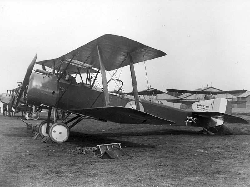 No Idea of location, but the aircraft is most likely to be a Sopwith 11/2 Strutter |
Rex Phare |
Monday 25th of June 2012 05:35:56 PM |