
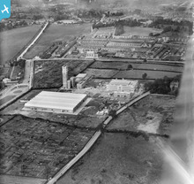
EPW017228 ENGLAND (1926). Terry's Chocolate Factory and environs, York, 1926

© Copyright OpenStreetMap contributors and licensed by the OpenStreetMap Foundation. 2025. Cartography is licensed as CC BY-SA.
Nearby Images (15)
EPW017228

EPW039033

EPW017227

EPW017226

EPW039025

EPW039031

EPW039029

EPW039032

EPW016068
, York, 1926")
EPW039027

EPW039026

EPW039030

EPW039034

EPW039028

EAW009405

Details
| Title | [EPW017228] Terry's Chocolate Factory and environs, York, 1926 |
| Reference | EPW017228 |
| Date | 16-October-1926 |
| Link | |
| Place name | YORK |
| Parish | |
| District | |
| Country | ENGLAND |
| Easting / Northing | 459918, 449817 |
| Longitude / Latitude | -1.0871075836514, 53.940794711099 |
| National Grid Reference | SE599498 |
Pins
 Cooper1214 |
Thursday 14th of February 2013 08:06:27 PM | |
 Class31 |
Wednesday 23rd of January 2013 04:33:56 PM |
User Comment Contributions
 Added to 'Terry's of York' group - http://www.britainfromabove.org.uk/groups/terrys-york |
YorkStories |
Thursday 16th of May 2013 09:59:20 PM |
Adding to group http://www.britainfromabove.org.uk/groups/terrys-york |
YorkStories |
Thursday 16th of May 2013 05:23:08 PM |