
XPW043557 IRELAND (1933). General View, Enniscorthy, Wexford, Ireland, 1933. Oblique aerial photograph taken facing West.

© Copyright OpenStreetMap contributors and licensed by the OpenStreetMap Foundation. 2024. Cartography is licensed as CC BY-SA.
Nearby Images (2)
XPW043557

XPW043559

Details
| Title | [XPW043557] General View, Enniscorthy, Wexford, Ireland, 1933. Oblique aerial photograph taken facing West. |
| Reference | XPW043557 |
| Date | 1933 |
| Link | |
| Place name | ENNISCORTHY |
| Parish | IRELAND |
| District | |
| Country | IRELAND |
| Easting / Northing | 90110, 299046 |
| Longitude / Latitude | -6.567692, 52.50101 |
| National Grid Reference |
Pins
 John Swain |
Tuesday 7th of October 2014 02:31:51 PM | |
John Swain |
Tuesday 7th of October 2014 02:29:35 PM | |
John Swain |
Tuesday 7th of October 2014 02:28:53 PM | |
John Swain |
Tuesday 7th of October 2014 02:27:33 PM | |
John Swain |
Tuesday 7th of October 2014 02:26:29 PM | |
John Swain |
Tuesday 7th of October 2014 02:25:29 PM | |
John Swain |
Tuesday 7th of October 2014 02:24:15 PM | |
John Swain |
Tuesday 7th of October 2014 02:23:04 PM | |
John Swain |
Tuesday 7th of October 2014 02:22:12 PM | |
John Swain |
Tuesday 7th of October 2014 02:21:13 PM | |
John Swain |
Tuesday 7th of October 2014 02:20:19 PM | |
John Swain |
Tuesday 7th of October 2014 02:19:12 PM | |
John Swain |
Tuesday 7th of October 2014 02:12:43 PM | |
John Swain |
Tuesday 7th of October 2014 02:12:03 PM | |
John Swain |
Tuesday 7th of October 2014 02:09:55 PM | |
John Swain |
Tuesday 7th of October 2014 02:08:39 PM | |
John Swain |
Tuesday 7th of October 2014 02:08:01 PM | |
John Swain |
Tuesday 7th of October 2014 02:07:26 PM | |
John Swain |
Tuesday 7th of October 2014 02:06:57 PM | |
John Swain |
Tuesday 7th of October 2014 02:04:43 PM | |
John Swain |
Tuesday 7th of October 2014 02:03:28 PM | |
John Swain |
Tuesday 7th of October 2014 02:02:54 PM | |
John Swain |
Tuesday 7th of October 2014 02:02:14 PM | |
John Swain |
Tuesday 7th of October 2014 02:01:30 PM | |
John Swain |
Tuesday 7th of October 2014 02:00:39 PM |
User Comment Contributions
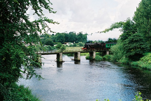 "Sea Breeze" No.4, 2-6-4T, is seen crossing Enniscorthy Bridge in July 2007. This locomotive was built in Derby by the London, Midland & Scottish Railway in 1947 before seeing service in Northern Ireland until 1970. It has been restored and owned by the Railway Preservation Society of Ireland. It will continue its sedate journey down to Rosslare, via the Wexford Quayside. |
John Swain |
Monday 13th of October 2014 01:45:54 PM |
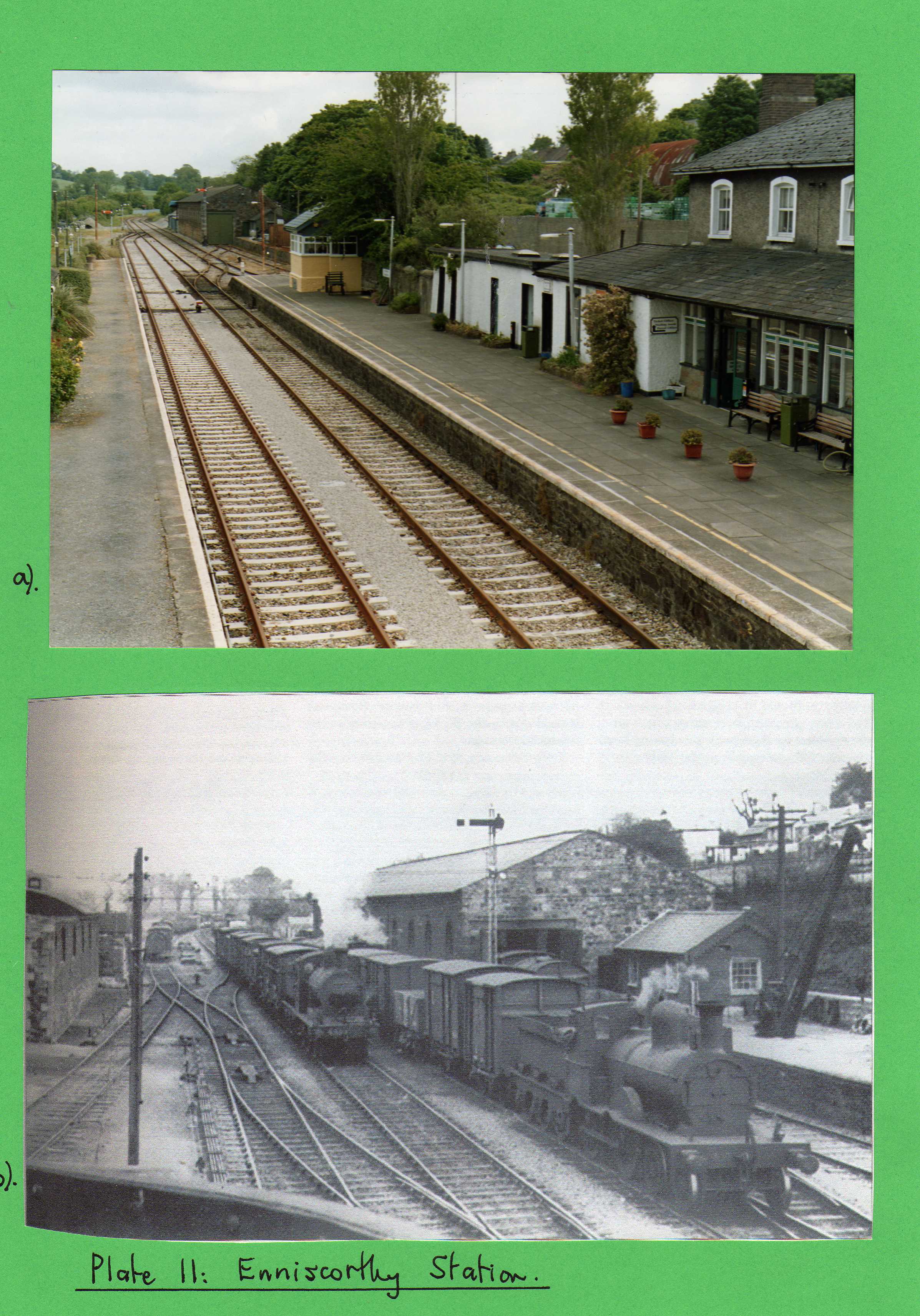 Enniscorthy Railway station in 1935 and 2005. The Great Southern Railway shot shows the engine shed on the left and the goods store opposite in a view at the Dublin end of the platform taken from the water tower, looking in a north-easterly direction. Water for the two columns was taken from the Slaney River by steam pump. The busy nature of the station is clearly indicated by the presence of two locomotives and numerous wagons in the sidings. The 2005 photo is looking from the footbridge towards the main station buildings, with the signal box and goods shed beyond. Most of the traffic at the station is now concerned with commuters to and from Dublin. |
John Swain |
Monday 13th of October 2014 01:39:57 PM |


