
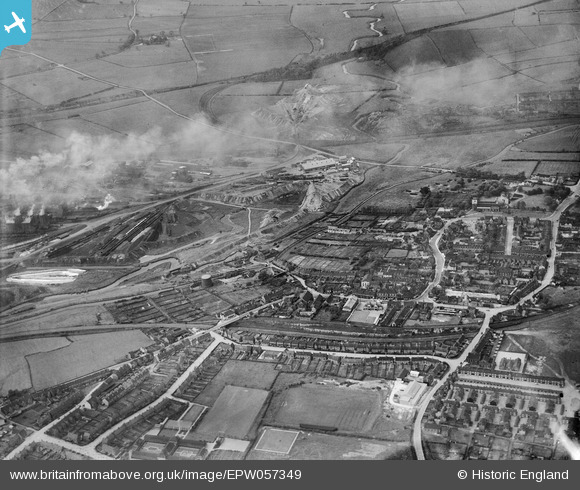
EPW057349 ENGLAND (1938). The town and environs, Staveley, 1938
© Copyright OpenStreetMap contributors and licensed by the OpenStreetMap Foundation. 2024. Cartography is licensed as CC BY-SA.
Nearby Images (7)
EPW057349

EAW044347

EPW041675

EAW003073

EAW003071

EPW057339

EAW003065

Details
| Title | [EPW057349] The town and environs, Staveley, 1938 |
| Reference | EPW057349 |
| Date | 3-June-1938 |
| Link | |
| Place name | STAVELEY |
| Parish | STAVELEY |
| District | |
| Country | ENGLAND |
| Easting / Northing | 443021, 374844 |
| Longitude / Latitude | -1.3548757003192, 53.268563612306 |
| National Grid Reference | SK430748 |
Pins
 Waldemar |
Tuesday 7th of April 2020 07:51:47 AM | |
Waldemar |
Tuesday 7th of April 2020 07:51:04 AM | |
Lady Jasper |
Saturday 28th of December 2019 09:16:18 PM | |
Maitland |
Saturday 5th of July 2014 05:43:23 PM | |
Maitland |
Saturday 5th of July 2014 05:39:56 PM | |
Maitland |
Saturday 5th of July 2014 12:13:45 AM | |
Taylor986 |
Friday 4th of July 2014 08:54:18 PM | |
Taylor986 |
Friday 4th of July 2014 08:53:22 PM | |
j miller |
Monday 11th of November 2013 12:43:25 PM | |
j miller |
Monday 11th of November 2013 12:42:10 PM | |
j miller |
Monday 11th of November 2013 12:41:20 PM | |
j miller |
Monday 11th of November 2013 12:40:25 PM | |
j miller |
Monday 11th of November 2013 12:39:10 PM |


