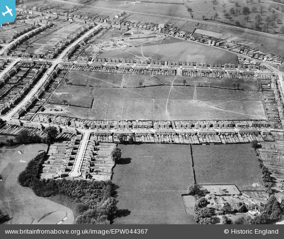
EPW044367 ENGLAND (1934). Penhill Park Recreation Ground and environs, Sidcup, 1934
© Copyright OpenStreetMap contributors and licensed by the OpenStreetMap Foundation. 2024. Cartography is licensed as CC BY-SA.
Nearby Images (15)
Details
| Title | [EPW044367] Penhill Park Recreation Ground and environs, Sidcup, 1934 |
| Reference | EPW044367 |
| Date | May-1934 |
| Link | |
| Place name | SIDCUP |
| Parish | |
| District | |
| Country | ENGLAND |
| Easting / Northing | 546997, 173826 |
| Longitude / Latitude | 0.1154345605064, 51.443832366982 |
| National Grid Reference | TQ470738 |
Pins
Be the first to add a comment to this image!


![[EPW044367] Penhill Park Recreation Ground and environs, Sidcup, 1934](http://britainfromabove.org.uk/sites/all/libraries/aerofilms-images/public/100x100/EPW/044/EPW044367.jpg)
![[EPW040882] The Penhill Park Estate, Sidcup Golf Course and environs, Bexley, 1933](http://britainfromabove.org.uk/sites/all/libraries/aerofilms-images/public/100x100/EPW/040/EPW040882.jpg)
![[EPW044364] Penhill Park Recreation Ground and environs, Sidcup, 1934](http://britainfromabove.org.uk/sites/all/libraries/aerofilms-images/public/100x100/EPW/044/EPW044364.jpg)
![[EPW038439] New housing site near Blackfen and Lamorbey Park Golf Course, Bexley, 1932](http://britainfromabove.org.uk/sites/all/libraries/aerofilms-images/public/100x100/EPW/038/EPW038439.jpg)
![[EPW040878] Construction of the Penhill Park Estate at Harcourt Avenue and environs, Bexley, 1933](http://britainfromabove.org.uk/sites/all/libraries/aerofilms-images/public/100x100/EPW/040/EPW040878.jpg)
![[EPW044370] Penhill Park Recreation Ground and environs, Sidcup, 1934](http://britainfromabove.org.uk/sites/all/libraries/aerofilms-images/public/100x100/EPW/044/EPW044370.jpg)
![[EPW044363] Penhill Park Recreation Ground and environs, Sidcup, 1934](http://britainfromabove.org.uk/sites/all/libraries/aerofilms-images/public/100x100/EPW/044/EPW044363.jpg)
![[EPW044365] Ramillies Road, Rowley Avenue, Penhill Park Recreation Ground and environs, Sidcup, 1934](http://britainfromabove.org.uk/sites/all/libraries/aerofilms-images/public/100x100/EPW/044/EPW044365.jpg)
![[EPW044368] Harcourt Avenue, Rowley Avenue and environs, Sidcup, 1934](http://britainfromabove.org.uk/sites/all/libraries/aerofilms-images/public/100x100/EPW/044/EPW044368.jpg)
![[EPW040879] Construction of the Penhill Park Estate at Harcourt Avenue and environs, Bexley, 1933](http://britainfromabove.org.uk/sites/all/libraries/aerofilms-images/public/100x100/EPW/040/EPW040879.jpg)
![[EPW040876] Construction of the Penhill Park Estate at Harcourt Avenue and environs, Bexley, 1933](http://britainfromabove.org.uk/sites/all/libraries/aerofilms-images/public/100x100/EPW/040/EPW040876.jpg)
![[EPW040887] Construction of the Penhill Park Estate at Harcourt Avenue, Bexley, 1933](http://britainfromabove.org.uk/sites/all/libraries/aerofilms-images/public/100x100/EPW/040/EPW040887.jpg)
![[EPW040881] Construction of the Penhill Park Estate at Harcourt Avenue and environs, Bexley, 1933](http://britainfromabove.org.uk/sites/all/libraries/aerofilms-images/public/100x100/EPW/040/EPW040881.jpg)
![[EPW040885] The Penhill Park Estate at Sherwood Park Avenue and environs, Bexley, 1933](http://britainfromabove.org.uk/sites/all/libraries/aerofilms-images/public/100x100/EPW/040/EPW040885.jpg)
![[EPW040883] Construction of the Penhill Park Estate at Harcourt Avenue and environs, Bexley, 1933](http://britainfromabove.org.uk/sites/all/libraries/aerofilms-images/public/100x100/EPW/040/EPW040883.jpg)


