
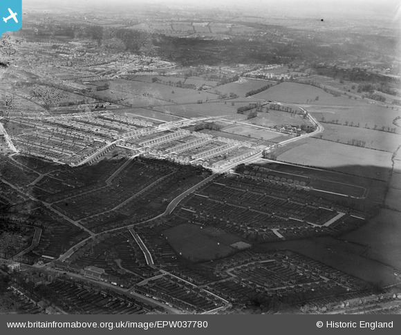
EPW037780 ENGLAND (1932). Housing estate centred upon Christchurch Avenue, Kenton, 1932
© Copyright OpenStreetMap contributors and licensed by the OpenStreetMap Foundation. 2024. Cartography is licensed as CC BY-SA.
Nearby Images (3)
EPW037780

EPW037775

EPW037776

Details
| Title | [EPW037780] Housing estate centred upon Christchurch Avenue, Kenton, 1932 |
| Reference | EPW037780 |
| Date | May-1932 |
| Link | |
| Place name | KENTON |
| Parish | |
| District | |
| Country | ENGLAND |
| Easting / Northing | 516966, 189627 |
| Longitude / Latitude | -0.31126891874575, 51.592861073135 |
| National Grid Reference | TQ170896 |
Pins
 The Laird |
Saturday 21st of March 2015 05:58:42 PM | |
The Laird |
Saturday 21st of March 2015 05:57:24 PM | |
tads |
Friday 26th of September 2014 08:43:19 PM | |
czyrko |
Sunday 27th of April 2014 05:14:09 PM | |
czyrko |
Sunday 27th of April 2014 05:13:47 PM | |
czyrko |
Sunday 27th of April 2014 05:12:24 PM | |
czyrko |
Sunday 27th of April 2014 05:10:38 PM | |
czyrko |
Sunday 27th of April 2014 05:06:42 PM | |
czyrko |
Sunday 27th of April 2014 05:05:53 PM | |
czyrko |
Sunday 27th of April 2014 05:04:47 PM | |
czyrko |
Sunday 27th of April 2014 05:04:13 PM |
User Comment Contributions
 Bottom two holes to south now under Vernon Drive allotments following land sale to Davis Estates. |
Lee P |
Tuesday 12th of November 2013 11:27:41 PM |


