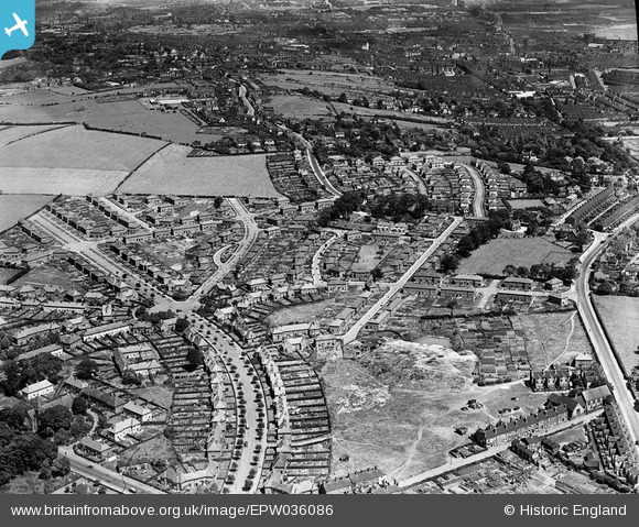
EPW036086 ENGLAND (1931). Trent Vale, Stoke-on-Trent, 1931
© Copyright OpenStreetMap contributors and licensed by the OpenStreetMap Foundation. 2024. Cartography is licensed as CC BY-SA.
Nearby Images (7)
Details
| Title | [EPW036086] Trent Vale, Stoke-on-Trent, 1931 |
| Reference | EPW036086 |
| Date | July-1931 |
| Link | |
| Place name | STOKE-ON-TRENT |
| Parish | |
| District | |
| Country | ENGLAND |
| Easting / Northing | 386622, 343884 |
| Longitude / Latitude | -2.1993248505516, 52.99181060411 |
| National Grid Reference | SJ866439 |
Pins
 cidge |
Tuesday 31st of July 2018 11:18:52 PM | |
 cidge |
Friday 27th of July 2018 12:02:03 PM | |
 cidge |
Friday 27th of July 2018 12:00:58 PM | |
 cidge |
Friday 27th of July 2018 11:59:59 AM | |
 cidge |
Friday 27th of July 2018 11:54:24 AM | |
 cidge |
Friday 27th of July 2018 11:48:21 AM | |
 cidge |
Friday 27th of July 2018 11:46:59 AM | |
 cidge |
Friday 27th of July 2018 11:32:48 AM | |
 cidge |
Friday 27th of July 2018 11:30:23 AM | |
 cidge |
Friday 27th of July 2018 11:29:28 AM | |
 cidge |
Wednesday 25th of July 2018 10:56:10 PM | |
 MildBunch |
Tuesday 3rd of March 2015 10:24:57 AM | |
 MildBunch |
Tuesday 3rd of March 2015 10:24:42 AM | |
 MildBunch |
Tuesday 3rd of March 2015 10:23:20 AM | |
 MildBunch |
Tuesday 3rd of March 2015 10:21:13 AM | |
 MildBunch |
Tuesday 3rd of March 2015 10:19:29 AM | |
 MildBunch |
Tuesday 3rd of March 2015 10:18:56 AM | |
 MildBunch |
Tuesday 3rd of March 2015 10:17:58 AM | |
 Ryleybags |
Monday 20th of October 2014 08:24:01 PM | |
 Ryleybags |
Monday 20th of October 2014 08:22:25 PM |


![[EPW036086] Trent Vale, Stoke-on-Trent, 1931](http://britainfromabove.org.uk/sites/all/libraries/aerofilms-images/public/100x100/EPW/036/EPW036086.jpg)
![[EPW036085] Trent Vale, Stoke-on-Trent, 1931](http://britainfromabove.org.uk/sites/all/libraries/aerofilms-images/public/100x100/EPW/036/EPW036085.jpg)
![[EPW036082] Trent Vale, Stoke-on-Trent, 1931](http://britainfromabove.org.uk/sites/all/libraries/aerofilms-images/public/100x100/EPW/036/EPW036082.jpg)
![[EPW036084] Trent Vale, Stoke-on-Trent, 1931](http://britainfromabove.org.uk/sites/all/libraries/aerofilms-images/public/100x100/EPW/036/EPW036084.jpg)
![[EPW036087] Trent Vale, Stoke-on-Trent, 1931](http://britainfromabove.org.uk/sites/all/libraries/aerofilms-images/public/100x100/EPW/036/EPW036087.jpg)
![[EPW036081] Trent Vale, Stoke-on-Trent, 1931](http://britainfromabove.org.uk/sites/all/libraries/aerofilms-images/public/100x100/EPW/036/EPW036081.jpg)
![[EPW036083] Trent Vale, Stoke-on-Trent, 1931](http://britainfromabove.org.uk/sites/all/libraries/aerofilms-images/public/100x100/EPW/036/EPW036083.jpg)