
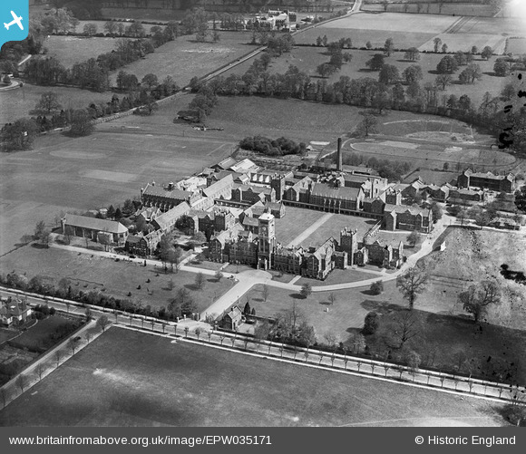
EPW035171 ENGLAND (1931). The Royal Masonic School for Boys, Bushey, 1931
© Copyright OpenStreetMap contributors and licensed by the OpenStreetMap Foundation. 2024. Cartography is licensed as CC BY-SA.
Nearby Images (5)
EPW035171

EPW049840

EPW035170

EPW035169

EAW018530

Details
| Title | [EPW035171] The Royal Masonic School for Boys, Bushey, 1931 |
| Reference | EPW035171 |
| Date | May-1931 |
| Link | |
| Place name | BUSHEY |
| Parish | |
| District | |
| Country | ENGLAND |
| Easting / Northing | 512861, 196150 |
| Longitude / Latitude | -0.36840767381369, 51.652331690597 |
| National Grid Reference | TQ129962 |
Pins
 Wordy |
Monday 5th of May 2014 06:28:03 PM | |
 John Swain |
Tuesday 21st of May 2013 09:53:50 AM | |
John Swain |
Tuesday 21st of May 2013 09:52:23 AM | |
John Swain |
Tuesday 21st of May 2013 09:51:28 AM | |
John Swain |
Tuesday 21st of May 2013 09:49:58 AM | |
John Swain |
Tuesday 21st of May 2013 09:48:46 AM | |
John Swain |
Tuesday 21st of May 2013 09:47:21 AM | |
John Swain |
Tuesday 21st of May 2013 09:45:30 AM | |
John Swain |
Tuesday 21st of May 2013 09:44:53 AM |
User Comment Contributions
Arguably, the best shot of the famous old school, looking almost due north on a sunny spring morning. The Royal Masonic School for Boys was re-located from north London (Wood Green) to Bushey in 1903 and the distinctive Grade II Listed Gothic building, in red brick and white Portland Stone, was designed by Victorian architects, Gordon, Lowther & Gunton. At its peak in the 1930s, over 800 boys attended the school and the Junior section was added, south of The Avenue, in 1929. As a pupil at Watford Boys' Grammar School, the writer has memories of playing cricket, hockey and rugby on the spacious facilities seen on this image between 1957 and 1960, always against ultra-competitive sides! However, my favourite recollection of this place has to be the dominant clock tower, by which the umpires at Bushey Cricket Club, on the Moat Field Ground, about half a mile away to the east, used to call time from 1926 until the club moved away to Hartspring Sports Centre in 1975. Due to falling rolls, the senior school was closed in 1977 and became the U.S.International University (Europe). My 2001 A-Z map shows that the site was a convent for a short while, before, in more recent times, this attractive location has been converted into a luxury housing scheme, Royal Connaught Park, set in 100 acres of parkland. |
John Swain |
Tuesday 21st of May 2013 09:42:44 AM |


