
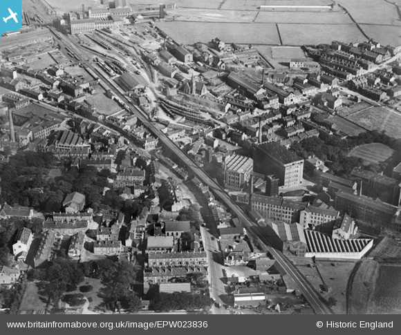
EPW023836 ENGLAND (1928). Leigh Mills and environs, Stanningley, 1928
© Copyright OpenStreetMap contributors and licensed by the OpenStreetMap Foundation. 2024. Cartography is licensed as CC BY-SA.
Nearby Images (17)
EPW023836

EPW028887

EAW025232

EPW034273

EAW025238

EAW031363

EAW025235

EPW023834

EAW031362

EAW031369

EAW031368

EAW025233

EAW031364

EAW031365

EAW031367

EAW031366

EAW025234

Details
| Title | [EPW023836] Leigh Mills and environs, Stanningley, 1928 |
| Reference | EPW023836 |
| Date | September-1928 |
| Link | |
| Place name | STANNINGLEY |
| Parish | |
| District | |
| Country | ENGLAND |
| Easting / Northing | 421996, 434320 |
| Longitude / Latitude | -1.6659672303859, 53.804497380306 |
| National Grid Reference | SE220343 |
Pins
 James |
Sunday 12th of February 2023 07:53:17 AM | |
James |
Wednesday 21st of December 2022 08:11:42 AM | |
James |
Wednesday 21st of December 2022 08:11:13 AM | |
James |
Wednesday 21st of December 2022 08:10:28 AM | |
James |
Wednesday 21st of December 2022 08:08:32 AM | |
James |
Wednesday 21st of December 2022 08:06:02 AM | |
PudseyRBL |
Tuesday 1st of October 2013 10:46:43 PM | |
PudseyRBL |
Tuesday 1st of October 2013 10:43:12 PM | |
PudseyRBL |
Tuesday 1st of October 2013 10:36:19 PM | |
PudseyRBL |
Tuesday 1st of October 2013 10:36:15 PM | |
lishman141089 |
Wednesday 21st of August 2013 12:17:50 PM | |
steve |
Thursday 28th of June 2012 04:38:14 PM | |
steve |
Thursday 28th of June 2012 04:34:11 PM | |
Meggymoo |
Wednesday 27th of June 2012 11:45:30 AM | |
Meggymoo |
Wednesday 27th of June 2012 11:43:34 AM | |
Meggymoo |
Wednesday 27th of June 2012 11:16:04 AM | |
Meggymoo |
Wednesday 27th of June 2012 11:12:53 AM |
User Comment Contributions
Could somebody please let me know if this is the Chapel and Chapel House? and if anyone has any information on it, it would be greatly appreaciated. thankyou |
lishman141089 |
Wednesday 21st of August 2013 12:16:40 PM |
Dear all, That’s great; we’ve reviewed your comments and thanks to your help we can update the catalogue, as for EPW023834. The revised record will appear here in due course. You may be interested to know that the original Aerofilms Ltd Register simply says "not located". Many thanks! Katy Whitaker Britain from Above Cataloguer |
Katy Whitaker |
Monday 2nd of July 2012 04:57:45 PM |
As the the tags show this is Stanningley Bottom looking SE |
Derek Bryant |
Sunday 1st of July 2012 04:13:23 PM |
this is showing the lower end of richardshaw lane looking towards leeds with stanningley station/goods yard |
steve |
Wednesday 27th of June 2012 02:45:50 PM |
This a view of Stanningley, between Leeds and Bradford. Stanningley, for Farsley, station is in the upper centre. The road on the right is Richardshaw Lane, going to Pudsey. More information available on request, John. |
John Whitaker |
Tuesday 26th of June 2012 01:49:39 PM |
Stanningley (between Leeds and Bradford) looking ESE. The station is Stanningley on Leeds - Bradford line and was closed in 1968. |
John |
Tuesday 26th of June 2012 08:35:00 AM |


