
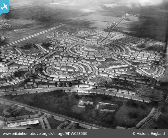
EPW023559 ENGLAND (1928). The Norris Green Estate, Liverpool, 1928
© Copyright OpenStreetMap contributors and licensed by the OpenStreetMap Foundation. 2024. Cartography is licensed as CC BY-SA.
Nearby Images (5)
EPW023559

EPW023562

EPW023565

EPW023564

EPW023566

Details
| Title | [EPW023559] The Norris Green Estate, Liverpool, 1928 |
| Reference | EPW023559 |
| Date | September-1928 |
| Link | |
| Place name | LIVERPOOL |
| Parish | |
| District | |
| Country | ENGLAND |
| Easting / Northing | 339220, 394281 |
| Longitude / Latitude | -2.9151339207592, 53.441535919171 |
| National Grid Reference | SJ392943 |
Pins
 Bottom Yard |
Monday 28th of January 2019 06:43:00 PM | |
Bottom Yard |
Monday 28th of January 2019 06:22:03 PM | |
Bottom Yard |
Monday 28th of January 2019 06:20:45 PM | |
Bottom Yard |
Monday 28th of January 2019 06:17:45 PM | |
Bottom Yard |
Monday 28th of January 2019 06:17:04 PM | |
Bottom Yard |
Monday 28th of January 2019 06:16:13 PM | |
Bottom Yard |
Monday 28th of January 2019 05:38:52 PM | |
Bottom Yard |
Monday 28th of January 2019 05:37:11 PM | |
Bottom Yard |
Monday 28th of January 2019 05:35:13 PM | |
Bottom Yard |
Monday 28th of January 2019 05:34:21 PM | |
Bottom Yard |
Monday 28th of January 2019 05:31:46 PM | |
Bottom Yard |
Monday 28th of January 2019 05:30:04 PM | |
Bottom Yard |
Monday 28th of January 2019 05:18:51 PM | |
Bottom Yard |
Monday 28th of January 2019 05:14:47 PM | |
Bottom Yard |
Monday 28th of January 2019 05:12:10 PM | |
Bottom Yard |
Monday 28th of January 2019 05:11:00 PM | |
Bottom Yard |
Monday 28th of January 2019 05:08:02 PM | |
Bottom Yard |
Monday 28th of January 2019 04:58:06 PM | |
Bottom Yard |
Monday 28th of January 2019 04:56:55 PM | |
Bottom Yard |
Monday 28th of January 2019 04:55:46 PM | |
Bob Fraser |
Saturday 14th of November 2015 09:35:49 AM | |
Bob Fraser |
Saturday 14th of November 2015 09:34:44 AM | |
Bob Fraser |
Saturday 14th of November 2015 09:33:29 AM |


