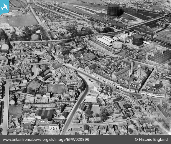
EPW020896 ENGLAND (1928). The town centre and Gas Works, Long Eaton, 1928
© Copyright OpenStreetMap contributors and licensed by the OpenStreetMap Foundation. 2024. Cartography is licensed as CC BY-SA.
Nearby Images (11)
EPW020896

EPW058194

EPW058191

EPW020898

EPW058196

EPW058195

EPW058192

EPW058188

EPW020902

EPW058193

EPW020897

Details
| Title | [EPW020896] The town centre and Gas Works, Long Eaton, 1928 |
| Reference | EPW020896 |
| Date | April-1928 |
| Link | |
| Place name | LONG EATON |
| Parish | |
| District | |
| Country | ENGLAND |
| Easting / Northing | 449153, 333654 |
| Longitude / Latitude | -1.2692288661456, 52.897759244222 |
| National Grid Reference | SK492337 |
Pins
 Keith Reedman |
Saturday 15th of November 2014 04:27:19 PM | |
TLeverton@aol.com |
Monday 23rd of September 2013 05:30:04 PM | |
TLeverton@aol.com |
Monday 23rd of September 2013 05:29:21 PM |