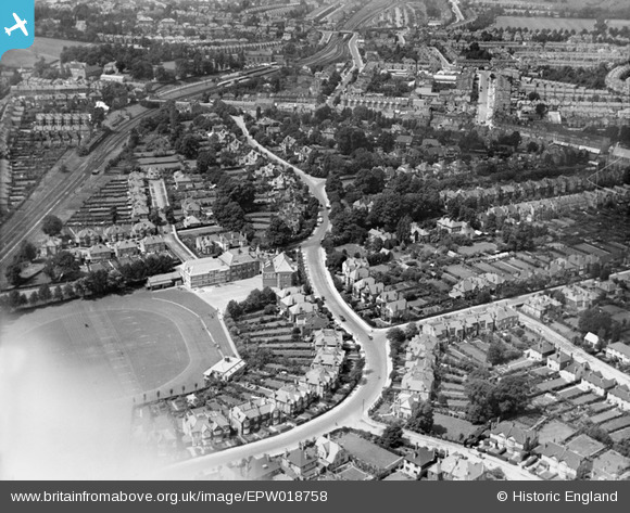
EPW018758 ENGLAND (1927). Gayton Road and environs, Harrow, 1927

© Copyright OpenStreetMap contributors and licensed by the OpenStreetMap Foundation. 2024. Cartography is licensed as CC BY-SA.

Nearby Images (3)

EPW018758
  0° 0m
EPW025537
  57° 176m
EPW018761
  115° 246m

Details

Title [EPW018758] Gayton Road and environs, Harrow, 1927
Reference EPW018758
Date July-1927
Link
Place name HARROW
Parish
District
Country ENGLAND
Easting / Northing 515916, 188140
Longitude / Latitude -0.32691274110639, 51.579712185518
National Grid Reference TQ159881

Pins

The two adjacent villas were incorporate as the Gayton Hotel, a residential hotel.

The Laird
Saturday 18th of February 2023 08:51:13 PM
These houses were acquired over time and the buildings incorporated as the Monksdene Hotel, a residential hotel. In the days before all-day licensing, the Monksdene housed a rather shady private members drinking den, called the Guinea Club. The Monksdene Hotel has now closed and the site redeveloped as a retirement home complex.

The Laird
Saturday 18th of February 2023 08:48:28 PM
The former Harrow South signal box.

The Laird
Saturday 18th of February 2023 08:41:22 PM
This building housed Harrow High School, one of the many independent schools that once abounded in the area. The name has now been adopted by Harrow County/Gayton High, which lived next door.

The Laird
Saturday 18th of February 2023 08:40:06 PM
Greenhill Laundry

The Laird
Saturday 18th of February 2023 08:28:47 PM
Marquis of Granby pub. Demolished in the early sixties to make way for an extension to the adjacent Sopers department store.

The Laird
Saturday 17th of November 2018 06:08:02 PM
Sopers department store.

The Laird
Saturday 17th of November 2018 06:06:14 PM
This is possibly the last pitch-roofed house that now remains in Sheepcote Road. It once housed a YWCA hostel and has now been adapted as a privately run pre-school nursery. All the others have been replaced by apartment blocks.

The Laird
Saturday 17th of November 2018 06:05:06 PM
There must, for some years, have been an intention by the Met railway to quadruple its tracks. A wide strip of vacant land appears to have been reserved between the existing railway and adjoining residential development.

The Laird
Saturday 17th of November 2018 05:56:10 PM
Harrow Goods Yard. This was once a very busy location, such that it warranted a its own dedicated shunting locomotive supplied, alternately every five years, by the Met Railway and the GCR/LNER.

The Laird
Saturday 17th of November 2018 05:49:51 PM
I'm not quite sure what this structure is. It's by the LNER lines at the end of Kenton Avenue. Perhaps it's a retaining wall that has been replaced more recently by something a little less obvious.

The Laird
Saturday 17th of November 2018 05:39:06 PM
Harrow County School for Girls

The Laird
Saturday 17th of November 2018 05:28:42 PM
I think this is No 28 Gayton Rd. I lived there from 1968 -72. This and the adjacent houses have since been replaced with low rise apartments with large car parks at the rear where the long back gardens used to be.

Coventry kid
Tuesday 2nd of August 2016 03:55:22 PM

Coventry kid
Tuesday 2nd of August 2016 03:53:04 PM
Northwick Park Rd

Coventry kid
Tuesday 2nd of August 2016 03:52:17 PM
Sheepcote Rd running across the photo from l to r.

Coventry kid
Tuesday 2nd of August 2016 03:51:27 PM

Sweet Pete
Monday 16th of March 2015 03:48:27 PM

Sweet Pete
Thursday 26th of February 2015 03:34:04 PM

Sweet Pete
Thursday 26th of February 2015 03:33:39 PM
Harrow-on-the-Hill Station

DLJ
Wednesday 27th of June 2012 12:06:47 AM
Harrow County School For Boys (1911-75), later Gayton High School, now Harrow High School.

DLJ
Wednesday 27th of June 2012 12:05:28 AM