
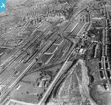
EPW017041 ENGLAND (1926). The Crewe Works, Crewe, 1926

© Copyright OpenStreetMap contributors and licensed by the OpenStreetMap Foundation. 2024. Cartography is licensed as CC BY-SA.
Nearby Images (3)
EPW017041

EAW013314

EPW017040

Details
| Title | [EPW017041] The Crewe Works, Crewe, 1926 |
| Reference | EPW017041 |
| Date | 6-October-1926 |
| Link | |
| Place name | CREWE |
| Parish | |
| District | |
| Country | ENGLAND |
| Easting / Northing | 369440, 355707 |
| Longitude / Latitude | -2.4564422370107, 53.097393098039 |
| National Grid Reference | SJ694557 |
Pins
 Creweboy |
Sunday 17th of January 2016 01:40:16 PM | |
Creweboy |
Sunday 17th of January 2016 01:39:53 PM | |
Creweboy |
Sunday 17th of January 2016 01:39:24 PM | |
Creweboy |
Sunday 17th of January 2016 01:38:43 PM | |
Creweboy |
Sunday 17th of January 2016 01:37:42 PM | |
Creweboy |
Sunday 17th of January 2016 01:36:43 PM | |
Creweboy |
Sunday 17th of January 2016 01:36:23 PM | |
Creweboy |
Sunday 17th of January 2016 01:35:48 PM | |
Crewedaddy |
Saturday 7th of June 2014 12:33:54 AM | |
Crewedaddy |
Saturday 7th of June 2014 12:33:11 AM | |
Crewedaddy |
Saturday 7th of June 2014 12:32:38 AM |
User Comment Contributions
 Crewe works just after the grouping |
Martin |
Sunday 19th of January 2014 10:19:06 PM |


