
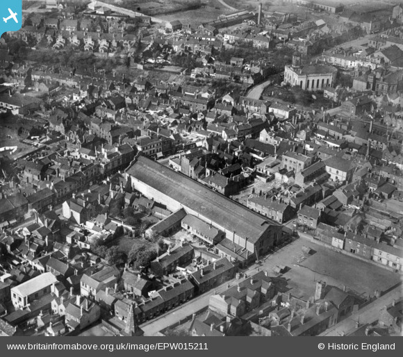
EPW015211 ENGLAND (1926). The Market Hall and the town centre, Bilston, 1926. This image has been produced from a copy-negative.
© Copyright OpenStreetMap contributors and licensed by the OpenStreetMap Foundation. 2024. Cartography is licensed as CC BY-SA.
Nearby Images (5)
EPW015211

EAW013294

EPW006730

EAW013285

EAW013284

Details
| Title | [EPW015211] The Market Hall and the town centre, Bilston, 1926. This image has been produced from a copy-negative. |
| Reference | EPW015211 |
| Date | 13-April-1926 |
| Link | |
| Place name | BILSTON |
| Parish | |
| District | |
| Country | ENGLAND |
| Easting / Northing | 394893, 296368 |
| Longitude / Latitude | -2.0753503133697, 52.564758532544 |
| National Grid Reference | SO949964 |
Pins
 dbm |
Wednesday 29th of October 2014 12:05:21 PM | |
dbm |
Wednesday 29th of October 2014 12:04:44 PM | |
dbm |
Wednesday 29th of October 2014 12:03:18 PM | |
dbm |
Wednesday 29th of October 2014 12:01:48 PM | |
dbm |
Wednesday 29th of October 2014 12:01:20 PM | |
dbm |
Wednesday 29th of October 2014 12:00:49 PM | |
dbm |
Wednesday 29th of October 2014 11:29:48 AM | |
dbm |
Wednesday 29th of October 2014 01:35:52 AM | |
dbm |
Wednesday 29th of October 2014 01:17:05 AM | |
dbm |
Wednesday 29th of October 2014 01:15:49 AM | |
dbm |
Wednesday 29th of October 2014 01:14:56 AM | |
dbm |
Wednesday 29th of October 2014 01:11:50 AM | |
dbm |
Wednesday 29th of October 2014 01:10:29 AM | |
dbm |
Wednesday 29th of October 2014 01:09:25 AM | |
dbm |
Wednesday 29th of October 2014 01:08:52 AM |


