
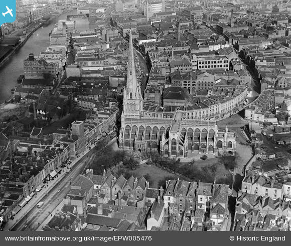
EPW005476 ENGLAND (1921). St Mary Redcliffe, Bristol, 1921
© Copyright OpenStreetMap contributors and licensed by the OpenStreetMap Foundation. 2024. Cartography is licensed as CC BY-SA.
Nearby Images (6)
EPW005476

EAW000739

EAW000738

EAW000737

EPW008824

EPW008820

Details
| Title | [EPW005476] St Mary Redcliffe, Bristol, 1921 |
| Reference | EPW005476 |
| Date | 20-March-1921 |
| Link | |
| Place name | BRISTOL |
| Parish | |
| District | |
| Country | ENGLAND |
| Easting / Northing | 359107, 172337 |
| Longitude / Latitude | -2.5885181938122, 51.448052229068 |
| National Grid Reference | ST591723 |
Pins
 MB |
Tuesday 30th of August 2016 10:32:04 PM | |
allenb1 |
Saturday 6th of June 2015 10:38:28 PM | |
brambly |
Thursday 22nd of May 2014 07:50:11 PM | |
brambly |
Tuesday 11th of December 2012 09:25:01 PM | |
brambly |
Tuesday 11th of December 2012 09:24:21 PM | |
brambly |
Tuesday 11th of December 2012 09:23:09 PM | |
kent |
Friday 27th of July 2012 12:12:22 AM | |
kent |
Friday 27th of July 2012 12:09:55 AM | |
kent |
Friday 27th of July 2012 12:08:56 AM | |
This seems to be THE shot tower. Watts, who lived here refined and patented (1782) the process of making shot using surface tension in falling droplets. Apparently the works carried on underground into early sandstone workings. This was sometimes (at least) disturbed by the ingress of the tides. The property was apparently destroyed for a traffic scheme in 1968. |
Chris Willis |
Sunday 9th of February 2014 05:02:47 PM |
kent |
Friday 27th of July 2012 12:08:24 AM | |
kent |
Friday 27th of July 2012 12:07:52 AM |


