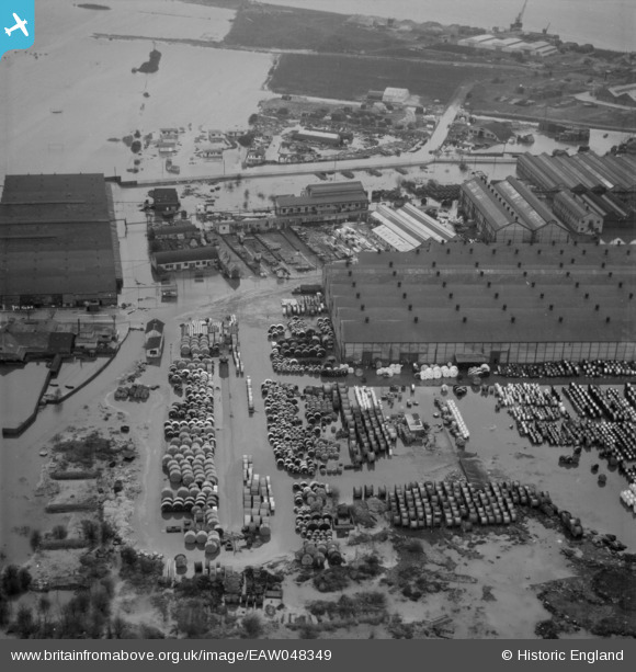
EAW048349 ENGLAND (1953). Flooding at the British Insulated Callender's Cables Ltd Erith Works, Erith, 1953
© Copyright OpenStreetMap contributors and licensed by the OpenStreetMap Foundation. 2024. Cartography is licensed as CC BY-SA.
Nearby Images (33)
Details
| Title | [EAW048349] Flooding at the British Insulated Callender's Cables Ltd Erith Works, Erith, 1953 |
| Reference | EAW048349 |
| Date | 3-February-1953 |
| Link | |
| Place name | ERITH |
| Parish | |
| District | |
| Country | ENGLAND |
| Easting / Northing | 550253, 179538 |
| Longitude / Latitude | 0.16468489232671, 51.494306659502 |
| National Grid Reference | TQ503795 |
Pins
Be the first to add a comment to this image!


![[EAW048349] Flooding at the British Insulated Callender's Cables Ltd Erith Works, Erith, 1953](http://britainfromabove.org.uk/sites/all/libraries/aerofilms-images/public/100x100/EAW/048/EAW048349.jpg)
![[EPW060718] Callender's Cable and Construction Company Ltd Works, Erith, 1939](http://britainfromabove.org.uk/sites/all/libraries/aerofilms-images/public/100x100/EPW/060/EPW060718.jpg)
![[EPW060716] Callender's Cable and Construction Company Ltd Works, Erith, 1939](http://britainfromabove.org.uk/sites/all/libraries/aerofilms-images/public/100x100/EPW/060/EPW060716.jpg)
![[EPW037306] Callender's Cable and Construction Company Ltd Works, Erith, from the west, 1932](http://britainfromabove.org.uk/sites/all/libraries/aerofilms-images/public/100x100/EPW/037/EPW037306.jpg)
![[EAW048350] Flooding at the British Insulated Callender's Cables Ltd Erith Works, Erith, 1953](http://britainfromabove.org.uk/sites/all/libraries/aerofilms-images/public/100x100/EAW/048/EAW048350.jpg)
![[EPW037311] Callender's Cable and Construction Company Ltd Works, Erith, 1932](http://britainfromabove.org.uk/sites/all/libraries/aerofilms-images/public/100x100/EPW/037/EPW037311.jpg)
![[EPW060656] Callender's Cable and Construction Company Ltd Works, Erith, 1939. This image has been produced from a damaged negative.](http://britainfromabove.org.uk/sites/all/libraries/aerofilms-images/public/100x100/EPW/060/EPW060656.jpg)
![[EAW014569] British Insulated Cables Ltd Works and environs, Erith, from the west, 1948. This image was marked by Aerofilms Ltd for photo editing.](http://britainfromabove.org.uk/sites/all/libraries/aerofilms-images/public/100x100/EAW/014/EAW014569.jpg)
![[EAW048347] Flooding at the British Insulated Callender's Cables Ltd Erith Works and environs, Erith, 1953. This image was marked by Aerofilms Ltd for photo editing.](http://britainfromabove.org.uk/sites/all/libraries/aerofilms-images/public/100x100/EAW/048/EAW048347.jpg)
![[EPW037305] Callender's Cable and Construction Company Ltd Works, Erith, from the west, 1932](http://britainfromabove.org.uk/sites/all/libraries/aerofilms-images/public/100x100/EPW/037/EPW037305.jpg)
![[EPW060715] Callender's Cable and Construction Company Ltd Works, Erith, 1939](http://britainfromabove.org.uk/sites/all/libraries/aerofilms-images/public/100x100/EPW/060/EPW060715.jpg)
![[EPW060654] Callender's Cable and Construction Company Ltd Works, Erith, 1939](http://britainfromabove.org.uk/sites/all/libraries/aerofilms-images/public/100x100/EPW/060/EPW060654.jpg)
![[EPW060714] Callender's Cable and Construction Company Ltd Works, Erith, 1939](http://britainfromabove.org.uk/sites/all/libraries/aerofilms-images/public/100x100/EPW/060/EPW060714.jpg)
![[EAW014574] The British Insulated Cables Ltd Works, Erith, from the west, 1948. This image has been produced from a damaged negative.](http://britainfromabove.org.uk/sites/all/libraries/aerofilms-images/public/100x100/EAW/014/EAW014574.jpg)
![[EPW037304] Callender's Cable and Construction Company Ltd Works, Erith, from the west, 1932](http://britainfromabove.org.uk/sites/all/libraries/aerofilms-images/public/100x100/EPW/037/EPW037304.jpg)
![[EPW060657] Callender's Cable and Construction Company Ltd Works, Erith, 1939](http://britainfromabove.org.uk/sites/all/libraries/aerofilms-images/public/100x100/EPW/060/EPW060657.jpg)
![[EAW048359] Flooding at the British Insulated Callender's Cables Ltd Erith Works and environs, Erith, 1953](http://britainfromabove.org.uk/sites/all/libraries/aerofilms-images/public/100x100/EAW/048/EAW048359.jpg)
![[EPW060713] Callender's Cable and Construction Company Ltd Works, Erith, 1939](http://britainfromabove.org.uk/sites/all/libraries/aerofilms-images/public/100x100/EPW/060/EPW060713.jpg)
![[EAW014571] British Insulated Cables Ltd Works, Erith, 1948. This image was marked by Aerofilms Ltd for photo editing.](http://britainfromabove.org.uk/sites/all/libraries/aerofilms-images/public/100x100/EAW/014/EAW014571.jpg)
![[EAW048351] Flooding at the British Insulated Callender's Cables Ltd Erith Works and environs, Erith, 1953](http://britainfromabove.org.uk/sites/all/libraries/aerofilms-images/public/100x100/EAW/048/EAW048351.jpg)
![[EPW060653] Callender's Cable and Construction Company Ltd Works and the River Thames, Erith, from the west, 1939](http://britainfromabove.org.uk/sites/all/libraries/aerofilms-images/public/100x100/EPW/060/EPW060653.jpg)
![[EAW048355] Flooding at the British Insulated Callender's Cables Ltd Erith Works, Erith, 1953](http://britainfromabove.org.uk/sites/all/libraries/aerofilms-images/public/100x100/EAW/048/EAW048355.jpg)
![[EAW014567] British Insulated Cables Ltd Works, Erith, 1948. This image was marked by Aerofilms Ltd for photo editing.](http://britainfromabove.org.uk/sites/all/libraries/aerofilms-images/public/100x100/EAW/014/EAW014567.jpg)
![[EAW048346] Flooding at the British Insulated Callender's Cables Ltd Erith Works and environs, Erith, 1953. This image was marked by Aerofilms Ltd for photo editing.](http://britainfromabove.org.uk/sites/all/libraries/aerofilms-images/public/100x100/EAW/048/EAW048346.jpg)
![[EPW060652] Callender's Cable and Construction Company Ltd Works, Erith, 1939](http://britainfromabove.org.uk/sites/all/libraries/aerofilms-images/public/100x100/EPW/060/EPW060652.jpg)
![[EPW060661] Callender's Cable and Construction Company Ltd Works, Erith, 1939](http://britainfromabove.org.uk/sites/all/libraries/aerofilms-images/public/100x100/EPW/060/EPW060661.jpg)
![[EAW014572] British Insulated Cables Ltd Works, Erith, 1948. This image has been produced from a damaged negative.](http://britainfromabove.org.uk/sites/all/libraries/aerofilms-images/public/100x100/EAW/014/EAW014572.jpg)
![[EPW062292] Callender's Cable and Construction Company Ltd Works, Erith, 1939](http://britainfromabove.org.uk/sites/all/libraries/aerofilms-images/public/100x100/EPW/062/EPW062292.jpg)
![[EPW037908] Callenders Cable Works, Erith, 1932](http://britainfromabove.org.uk/sites/all/libraries/aerofilms-images/public/100x100/EPW/037/EPW037908.jpg)
![[EAW048345] Flooding at the British Insulated Callender's Cables Ltd Erith Works and environs, Erith, 1953. This image was marked by Aerofilms Ltd for photo editing.](http://britainfromabove.org.uk/sites/all/libraries/aerofilms-images/public/100x100/EAW/048/EAW048345.jpg)
![[EPW060712] Callender's Cable and Construction Company Ltd Works, Erith, 1939](http://britainfromabove.org.uk/sites/all/libraries/aerofilms-images/public/100x100/EPW/060/EPW060712.jpg)
![[EPW060772] The River Thames from Plumstead towards Purfleet and beyond, Woolwich, from the west, 1939](http://britainfromabove.org.uk/sites/all/libraries/aerofilms-images/public/100x100/EPW/060/EPW060772.jpg)
![[EPW060658] Callender's Cable and Construction Company Ltd Works and the River Thames, Erith, 1939](http://britainfromabove.org.uk/sites/all/libraries/aerofilms-images/public/100x100/EPW/060/EPW060658.jpg)


