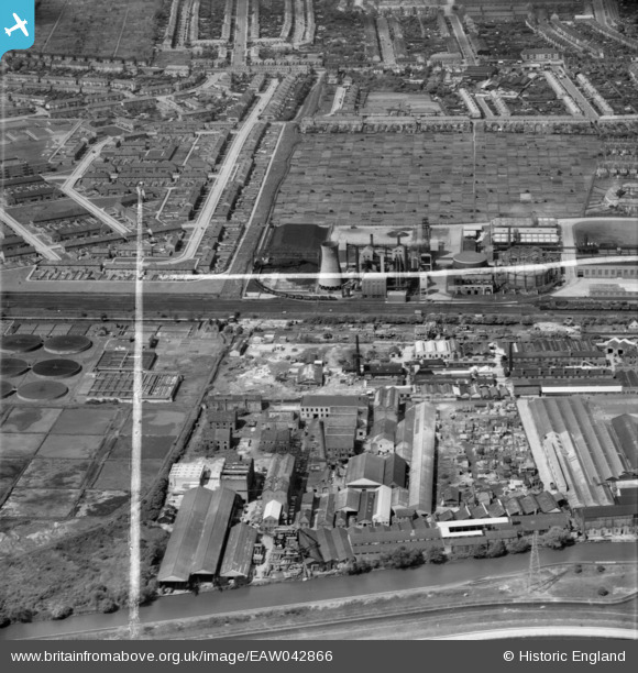
EAW042866 ENGLAND (1952). Riverside Industrial Estate and environs, Ponders End, 1952. This image was marked by Aerofilms Ltd for photo editing.
© Copyright OpenStreetMap contributors and licensed by the OpenStreetMap Foundation. 2024. Cartography is licensed as CC BY-SA.
Nearby Images (13)
Details
| Title | [EAW042866] Riverside Industrial Estate and environs, Ponders End, 1952. This image was marked by Aerofilms Ltd for photo editing. |
| Reference | EAW042866 |
| Date | 5-July-1952 |
| Link | |
| Place name | PONDERS END |
| Parish | |
| District | |
| Country | ENGLAND |
| Easting / Northing | 535994, 195173 |
| Longitude / Latitude | -0.034555744245203, 51.638430869875 |
| National Grid Reference | TQ360952 |
Pins
 Sparky |
Sunday 29th of October 2017 11:01:37 AM | |
 John Wass |
Monday 8th of June 2015 03:57:20 PM | |
 Grk |
Monday 30th of June 2014 10:04:33 PM | |
 Grk |
Monday 30th of June 2014 10:03:17 PM |


![[EAW042866] Riverside Industrial Estate and environs, Ponders End, 1952. This image was marked by Aerofilms Ltd for photo editing.](http://britainfromabove.org.uk/sites/all/libraries/aerofilms-images/public/100x100/EAW/042/EAW042866.jpg)
![[EAW042862] Riverside Industrial Estate and environs, Ponders End, 1952. This image was marked by Aerofilms Ltd for photo editing.](http://britainfromabove.org.uk/sites/all/libraries/aerofilms-images/public/100x100/EAW/042/EAW042862.jpg)
![[EAW042867] Riverside Industrial Estate and environs, Ponders End, 1952. This image was marked by Aerofilms Ltd for photo editing.](http://britainfromabove.org.uk/sites/all/libraries/aerofilms-images/public/100x100/EAW/042/EAW042867.jpg)
![[EAW042865] Riverside Industrial Estate and environs, Ponders End, 1952. This image was marked by Aerofilms Ltd for photo editing.](http://britainfromabove.org.uk/sites/all/libraries/aerofilms-images/public/100x100/EAW/042/EAW042865.jpg)
![[EAW042861] Riverside Industrial Estate and environs, Ponders End, 1952. This image was marked by Aerofilms Ltd for photo editing.](http://britainfromabove.org.uk/sites/all/libraries/aerofilms-images/public/100x100/EAW/042/EAW042861.jpg)
![[EAW042863] Riverside Industrial Estate and environs, Ponders End, from the north-east, 1952. This image was marked by Aerofilms Ltd for photo editing.](http://britainfromabove.org.uk/sites/all/libraries/aerofilms-images/public/100x100/EAW/042/EAW042863.jpg)
![[EAW042859] Riverside Industrial Estate, Ponders End, 1952. This image was marked by Aerofilms Ltd for photo editing.](http://britainfromabove.org.uk/sites/all/libraries/aerofilms-images/public/100x100/EAW/042/EAW042859.jpg)
![[EAW035937] The Tap & Die Corporation Ltd Warrior Works on the Riverside Industrial Estate, Ponders End, 1951. This image has been produced from a print marked by Aerofilms Ltd for photo editing.](http://britainfromabove.org.uk/sites/all/libraries/aerofilms-images/public/100x100/EAW/035/EAW035937.jpg)
![[EAW035939] The Tap & Die Corporation Ltd Warrior Works on the Riverside Industrial Estate, Ponders End, 1951. This image has been produced from a print marked by Aerofilms Ltd for photo editing.](http://britainfromabove.org.uk/sites/all/libraries/aerofilms-images/public/100x100/EAW/035/EAW035939.jpg)
![[EAW035935] The Tap & Die Corporation Ltd Warrior Works on the Riverside Industrial Estate, Ponders End, 1951. This image has been produced from a print marked by Aerofilms Ltd for photo editing.](http://britainfromabove.org.uk/sites/all/libraries/aerofilms-images/public/100x100/EAW/035/EAW035935.jpg)
![[EAW035941] The Tap & Die Corporation Ltd Warrior Works on the Riverside Industrial Estate, Ponders End, 1951. This image has been produced from a print marked by Aerofilms Ltd for photo editing.](http://britainfromabove.org.uk/sites/all/libraries/aerofilms-images/public/100x100/EAW/035/EAW035941.jpg)
![[EAW035938] The Tap & Die Corporation Ltd Warrior Works on the Riverside Industrial Estate, Ponders End, 1951. This image has been produced from a print marked by Aerofilms Ltd for photo editing.](http://britainfromabove.org.uk/sites/all/libraries/aerofilms-images/public/100x100/EAW/035/EAW035938.jpg)
![[EAW035940] The Tap & Die Corporation Ltd Warrior Works on the Riverside Industrial Estate, Ponders End, 1951. This image has been produced from a print marked by Aerofilms Ltd for photo editing.](http://britainfromabove.org.uk/sites/all/libraries/aerofilms-images/public/100x100/EAW/035/EAW035940.jpg)


