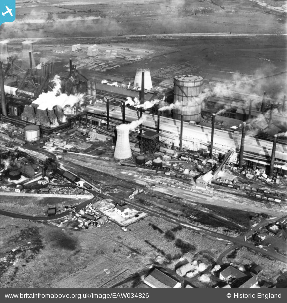
EAW034826 ENGLAND (1951). Part of the John Lysaght Normanby Park Steel Works, Scunthorpe, 1951. This image has been produced from a print.
© Copyright OpenStreetMap contributors and licensed by the OpenStreetMap Foundation. 2024. Cartography is licensed as CC BY-SA.
Nearby Images (48)
Details
| Title | [EAW034826] Part of the John Lysaght Normanby Park Steel Works, Scunthorpe, 1951. This image has been produced from a print. |
| Reference | EAW034826 |
| Date | 1-March-1951 |
| Link | |
| Place name | SCUNTHORPE |
| Parish | |
| District | |
| Country | ENGLAND |
| Easting / Northing | 488793, 413667 |
| Longitude / Latitude | -0.6576969400475, 53.611782434388 |
| National Grid Reference | SE888137 |
Pins
Be the first to add a comment to this image!


![[EAW034826] Part of the John Lysaght Normanby Park Steel Works, Scunthorpe, 1951. This image has been produced from a print.](http://britainfromabove.org.uk/sites/all/libraries/aerofilms-images/public/100x100/EAW/034/EAW034826.jpg)
![[EPW048524] The John Lysaght Normanby Park Steel Works, Scunthorpe, 1935](http://britainfromabove.org.uk/sites/all/libraries/aerofilms-images/public/100x100/EPW/048/EPW048524.jpg)
![[EPW048527] The John Lysaght Normanby Park Steel Works, Scunthorpe, 1935](http://britainfromabove.org.uk/sites/all/libraries/aerofilms-images/public/100x100/EPW/048/EPW048527.jpg)
![[EPW048947] The John Lysaght Normanby Park Steel Works, Scunthorpe, 1935. This image has been produced from a damaged negative.](http://britainfromabove.org.uk/sites/all/libraries/aerofilms-images/public/100x100/EPW/048/EPW048947.jpg)
![[EAW038748] John Lysaght Ltd Normanby Park Steel Works, Scunthorpe, 1951. This image has been produced from a print.](http://britainfromabove.org.uk/sites/all/libraries/aerofilms-images/public/100x100/EAW/038/EAW038748.jpg)
![[EAW038763] Part of the John Lysaght Ltd Normanby Park Steel Works, Scunthorpe, 1951. This image has been produced from a print marked by Aerofilms Ltd for photo editing.](http://britainfromabove.org.uk/sites/all/libraries/aerofilms-images/public/100x100/EAW/038/EAW038763.jpg)
![[EAW034800] The John Lysaght Normanby Park Steel Works, Scunthorpe, 1951. This image has been produced from a print.](http://britainfromabove.org.uk/sites/all/libraries/aerofilms-images/public/100x100/EAW/034/EAW034800.jpg)
![[EAW027186] The John Lysaght Normanby Park Steel Works, Scunthorpe, 1949](http://britainfromabove.org.uk/sites/all/libraries/aerofilms-images/public/100x100/EAW/027/EAW027186.jpg)
![[EAW023924] The John Lysaght Normanby Park Steel Works, Scunthorpe, 1949](http://britainfromabove.org.uk/sites/all/libraries/aerofilms-images/public/100x100/EAW/023/EAW023924.jpg)
![[EAW038760] John Lysaght Ltd Normanby Park Steel Works, Scunthorpe, 1951. This image has been produced from a print.](http://britainfromabove.org.uk/sites/all/libraries/aerofilms-images/public/100x100/EAW/038/EAW038760.jpg)
![[EAW009629] The John Lysaght Normanby Park Steel Works, Scunthorpe, 1947](http://britainfromabove.org.uk/sites/all/libraries/aerofilms-images/public/100x100/EAW/009/EAW009629.jpg)
![[EPW048949] The John Lysaght Normanby Park Steel Works, Scunthorpe, 1935](http://britainfromabove.org.uk/sites/all/libraries/aerofilms-images/public/100x100/EPW/048/EPW048949.jpg)
![[EAW009639] The John Lysaght Normanby Park Steel Works, Scunthorpe, 1947](http://britainfromabove.org.uk/sites/all/libraries/aerofilms-images/public/100x100/EAW/009/EAW009639.jpg)
![[EAW016664] John Lysaght Ltd Normanby Park Steel Works and environs, Scunthorpe, 1948](http://britainfromabove.org.uk/sites/all/libraries/aerofilms-images/public/100x100/EAW/016/EAW016664.jpg)
![[EPW048525] The John Lysaght Normanby Park Steel Works, Scunthorpe, 1935](http://britainfromabove.org.uk/sites/all/libraries/aerofilms-images/public/100x100/EPW/048/EPW048525.jpg)
![[EPW048943] The John Lysaght Normanby Park Steel Works, Scunthorpe, 1935. This image has been produced from a damaged negative.](http://britainfromabove.org.uk/sites/all/libraries/aerofilms-images/public/100x100/EPW/048/EPW048943.jpg)
![[EAW016666] John Lysaght Ltd Normanby Park Steel Works, Scunthorpe, 1948. This image was marked by Aerofilms Ltd for photo editing.](http://britainfromabove.org.uk/sites/all/libraries/aerofilms-images/public/100x100/EAW/016/EAW016666.jpg)
![[EPW048531] The John Lysaght Normanby Park Steel Works, Scunthorpe, 1935](http://britainfromabove.org.uk/sites/all/libraries/aerofilms-images/public/100x100/EPW/048/EPW048531.jpg)
![[EAW034825] Part of the John Lysaght Normanby Park Steel Works, Scunthorpe, 1951. This image has been produced from a print.](http://britainfromabove.org.uk/sites/all/libraries/aerofilms-images/public/100x100/EAW/034/EAW034825.jpg)
![[EPW016304] The Frodingham Iron Works, Scunthorpe, 1926](http://britainfromabove.org.uk/sites/all/libraries/aerofilms-images/public/100x100/EPW/016/EPW016304.jpg)
![[EPW048521] The John Lysaght Normanby Park Steel Works, Scunthorpe, 1935](http://britainfromabove.org.uk/sites/all/libraries/aerofilms-images/public/100x100/EPW/048/EPW048521.jpg)
![[EAW027174] The John Lysaght Normanby Park Steel Works, Scunthorpe, 1949. This image has been produced from a damaged negative.](http://britainfromabove.org.uk/sites/all/libraries/aerofilms-images/public/100x100/EAW/027/EAW027174.jpg)
![[EAW031185] The John Lysaght Normanby Park Steel Works, Scunthorpe, 1950](http://britainfromabove.org.uk/sites/all/libraries/aerofilms-images/public/100x100/EAW/031/EAW031185.jpg)
![[EAW028574] The John Lysaght Normanby Park Steel Works, Scunthorpe, 1950](http://britainfromabove.org.uk/sites/all/libraries/aerofilms-images/public/100x100/EAW/028/EAW028574.jpg)
![[EAW027175] The John Lysaght Normanby Park Steel Works, Scunthorpe, 1949. This image has been produced from a damaged negative.](http://britainfromabove.org.uk/sites/all/libraries/aerofilms-images/public/100x100/EAW/027/EAW027175.jpg)
![[EAW027173] The John Lysaght Normanby Park Steel Works, Scunthorpe, 1949. This image has been produced from a print.](http://britainfromabove.org.uk/sites/all/libraries/aerofilms-images/public/100x100/EAW/027/EAW027173.jpg)
![[EAW034812] Part of the John Lysaght Normanby Park Steel Works, Scunthorpe, 1951. This image has been produced from a print.](http://britainfromabove.org.uk/sites/all/libraries/aerofilms-images/public/100x100/EAW/034/EAW034812.jpg)
![[EAW049666] The John Lysaght Normanby Park Steel Works, Scunthorpe, 1953](http://britainfromabove.org.uk/sites/all/libraries/aerofilms-images/public/100x100/EAW/049/EAW049666.jpg)
![[EAW028572] The John Lysaght Normanby Park Steel Works, Scunthorpe, 1950](http://britainfromabove.org.uk/sites/all/libraries/aerofilms-images/public/100x100/EAW/028/EAW028572.jpg)
![[EAW028567] The John Lysaght Normanby Park Steel Works, Scunthorpe, 1950](http://britainfromabove.org.uk/sites/all/libraries/aerofilms-images/public/100x100/EAW/028/EAW028567.jpg)
![[EAW028565] Part of the John Lysaght Normanby Park Steel Works, Scunthorpe, 1950. This image was marked by Aerofilms Ltd for photo editing.](http://britainfromabove.org.uk/sites/all/libraries/aerofilms-images/public/100x100/EAW/028/EAW028565.jpg)
![[EAW031184] The John Lysaght Normanby Park Steel Works, Scunthorpe, 1950](http://britainfromabove.org.uk/sites/all/libraries/aerofilms-images/public/100x100/EAW/031/EAW031184.jpg)
![[EAW031190] The John Lysaght Normanby Park Steel Works, Scunthorpe, 1950](http://britainfromabove.org.uk/sites/all/libraries/aerofilms-images/public/100x100/EAW/031/EAW031190.jpg)
![[EAW049670] The John Lysaght Normanby Park Steel Works, Scunthorpe, 1953. This image was marked by Aerofilms Ltd for photo editing.](http://britainfromabove.org.uk/sites/all/libraries/aerofilms-images/public/100x100/EAW/049/EAW049670.jpg)
![[EAW027172] The John Lysaght Normanby Park Steel Works, Scunthorpe, 1949. This image has been produced from a print.](http://britainfromabove.org.uk/sites/all/libraries/aerofilms-images/public/100x100/EAW/027/EAW027172.jpg)
![[EAW031186] The John Lysaght Normanby Park Steel Works, Scunthorpe, 1950. This image was marked by Aerofilms Ltd for photo editing.](http://britainfromabove.org.uk/sites/all/libraries/aerofilms-images/public/100x100/EAW/031/EAW031186.jpg)
![[EAW028573] Part of the John Lysaght Normanby Park Steel Works, Scunthorpe, 1950](http://britainfromabove.org.uk/sites/all/libraries/aerofilms-images/public/100x100/EAW/028/EAW028573.jpg)
![[EAW038769] John Lysaght Ltd Normanby Park Steel Works, Scunthorpe, 1951. This image has been produced from a print marked by Aerofilms Ltd for photo editing.](http://britainfromabove.org.uk/sites/all/libraries/aerofilms-images/public/100x100/EAW/038/EAW038769.jpg)
![[EAW016667] John Lysaght Ltd Normanby Park Steel Works and environs, Scunthorpe, 1948](http://britainfromabove.org.uk/sites/all/libraries/aerofilms-images/public/100x100/EAW/016/EAW016667.jpg)
![[EAW049672] The John Lysaght Normanby Park Steel Works, Scunthorpe, 1953. This image was marked by Aerofilms Ltd for photo editing.](http://britainfromabove.org.uk/sites/all/libraries/aerofilms-images/public/100x100/EAW/049/EAW049672.jpg)
![[EAW038761] John Lysaght Ltd Normanby Park Steel Works, Scunthorpe, 1951. This image has been produced from a print.](http://britainfromabove.org.uk/sites/all/libraries/aerofilms-images/public/100x100/EAW/038/EAW038761.jpg)
![[EAW038762] Part of the John Lysaght Ltd Normanby Park Steel Works, Scunthorpe, 1951. This image has been produced from a print marked by Aerofilms Ltd for photo editing.](http://britainfromabove.org.uk/sites/all/libraries/aerofilms-images/public/100x100/EAW/038/EAW038762.jpg)
![[EAW009409] The John Lysaght Normanby Park Steel Works, Scunthorpe, from the south-west, 1947. This image has been produced from a print.](http://britainfromabove.org.uk/sites/all/libraries/aerofilms-images/public/100x100/EAW/009/EAW009409.jpg)
![[EAW028566] The John Lysaght Normanby Park Steel Works, Scunthorpe, 1950](http://britainfromabove.org.uk/sites/all/libraries/aerofilms-images/public/100x100/EAW/028/EAW028566.jpg)
![[EAW049665] The John Lysaght Normanby Park Steel Works, Scunthorpe, 1953. This image was marked by Aerofilms Ltd for photo editing.](http://britainfromabove.org.uk/sites/all/libraries/aerofilms-images/public/100x100/EAW/049/EAW049665.jpg)
![[EAW041850] Part of the John Lysaght Normanby Park Steel Works, Scunthorpe, 1952. This image has been produced from a print marked by Aerofilms Ltd for photo editing.](http://britainfromabove.org.uk/sites/all/libraries/aerofilms-images/public/100x100/EAW/041/EAW041850.jpg)
![[EAW049663] The John Lysaght Normanby Park Steel Works, Scunthorpe, 1953. This image was marked by Aerofilms Ltd for photo editing.](http://britainfromabove.org.uk/sites/all/libraries/aerofilms-images/public/100x100/EAW/049/EAW049663.jpg)
![[EPW048944] The John Lysaght Normanby Park Steel Works, Scunthorpe, 1935. This image has been produced from a damaged negative.](http://britainfromabove.org.uk/sites/all/libraries/aerofilms-images/public/100x100/EPW/048/EPW048944.jpg)


