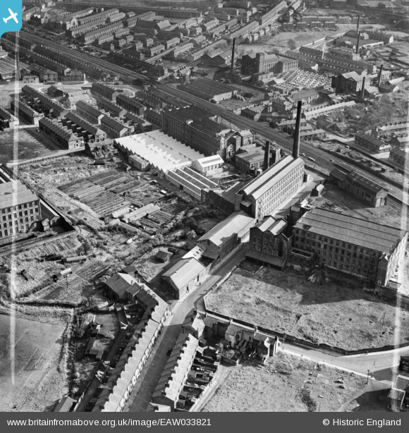
EAW033821 ENGLAND (1950). Waterfall Mills and Waterfall Nurseries, Mill Hill, 1950. This image was marked by Aerofilms Ltd for photo editing.
© Copyright OpenStreetMap contributors and licensed by the OpenStreetMap Foundation. 2024. Cartography is licensed as CC BY-SA.
Nearby Images (14)
Details
| Title | [EAW033821] Waterfall Mills and Waterfall Nurseries, Mill Hill, 1950. This image was marked by Aerofilms Ltd for photo editing. |
| Reference | EAW033821 |
| Date | 16-October-1950 |
| Link | |
| Place name | MILL HILL |
| Parish | |
| District | |
| Country | ENGLAND |
| Easting / Northing | 367070, 426825 |
| Longitude / Latitude | -2.4992714077861, 53.736549640562 |
| National Grid Reference | SD671268 |


![[EAW033821] Waterfall Mills and Waterfall Nurseries, Mill Hill, 1950. This image was marked by Aerofilms Ltd for photo editing.](http://britainfromabove.org.uk/sites/all/libraries/aerofilms-images/public/100x100/EAW/033/EAW033821.jpg)
![[EAW033817] Mill Hill Mill and the Waterfall Mills, Mill Hill, 1950. This image was marked by Aerofilms Ltd for photo editing.](http://britainfromabove.org.uk/sites/all/libraries/aerofilms-images/public/100x100/EAW/033/EAW033817.jpg)
![[EAW033822] Mill Hill Mill, the Waterfall Mills and Waterfall Nurseries, Mill Hill, 1950. This image was marked by Aerofilms Ltd for photo editing.](http://britainfromabove.org.uk/sites/all/libraries/aerofilms-images/public/100x100/EAW/033/EAW033822.jpg)
![[EAW033818] Waterfall Mills, Mill Hill, 1950. This image was marked by Aerofilms Ltd for photo editing.](http://britainfromabove.org.uk/sites/all/libraries/aerofilms-images/public/100x100/EAW/033/EAW033818.jpg)
![[EAW033813] Waterfall Mills, Mill Hill, 1950. This image was marked by Aerofilms Ltd for photo editing.](http://britainfromabove.org.uk/sites/all/libraries/aerofilms-images/public/100x100/EAW/033/EAW033813.jpg)
![[EAW033816] Waterfall Mills, Mill Hill, 1950. This image was marked by Aerofilms Ltd for photo editing.](http://britainfromabove.org.uk/sites/all/libraries/aerofilms-images/public/100x100/EAW/033/EAW033816.jpg)
![[EAW033820] Waterfall Mills and Waterfall Nurseries, Mill Hill, 1950. This image was marked by Aerofilms Ltd for photo editing.](http://britainfromabove.org.uk/sites/all/libraries/aerofilms-images/public/100x100/EAW/033/EAW033820.jpg)
![[EAW033815] Mill Hill Mill and the Waterfall Mills, Mill Hill, 1950. This image was marked by Aerofilms Ltd for photo editing.](http://britainfromabove.org.uk/sites/all/libraries/aerofilms-images/public/100x100/EAW/033/EAW033815.jpg)
![[EAW033814] Waterfall Mills and Waterfall Nurseries, Mill Hill, 1950. This image was marked by Aerofilms Ltd for photo editing.](http://britainfromabove.org.uk/sites/all/libraries/aerofilms-images/public/100x100/EAW/033/EAW033814.jpg)
![[EAW033819] Waterfall Mills and Waterfall Nurseries, Mill Hill, 1950. This image was marked by Aerofilms Ltd for photo editing.](http://britainfromabove.org.uk/sites/all/libraries/aerofilms-images/public/100x100/EAW/033/EAW033819.jpg)
![[EAW033824] Waterfall Mills, Mill Hill, 1950. This image was marked by Aerofilms Ltd for photo editing.](http://britainfromabove.org.uk/sites/all/libraries/aerofilms-images/public/100x100/EAW/033/EAW033824.jpg)
![[EAW033823] Waterfall Mills, Mill Hill, 1950. This image was marked by Aerofilms Ltd for photo editing.](http://britainfromabove.org.uk/sites/all/libraries/aerofilms-images/public/100x100/EAW/033/EAW033823.jpg)
![[EPW013920] The Waterfall Mills and Blackburn and Preston Raillway, Blackburn, 1925](http://britainfromabove.org.uk/sites/all/libraries/aerofilms-images/public/100x100/EPW/013/EPW013920.jpg)
![[EAW028419] Witton Mill, Stancliffe Mill and environs, Blackburn, 1950. This image was marked by Aerofilms Ltd for photo editing.](http://britainfromabove.org.uk/sites/all/libraries/aerofilms-images/public/100x100/EAW/028/EAW028419.jpg)


