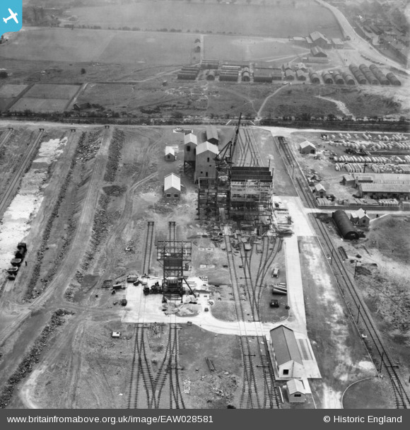
EAW028581 ENGLAND (1950). Part of the John Lysaght Normanby Park Steel Works, Scunthorpe, 1950
© Copyright OpenStreetMap contributors and licensed by the OpenStreetMap Foundation. 2024. Cartography is licensed as CC BY-SA.
Nearby Images (43)
Details
| Title | [EAW028581] Part of the John Lysaght Normanby Park Steel Works, Scunthorpe, 1950 |
| Reference | EAW028581 |
| Date | 5-April-1950 |
| Link | |
| Place name | SCUNTHORPE |
| Parish | |
| District | |
| Country | ENGLAND |
| Easting / Northing | 489075, 414182 |
| Longitude / Latitude | -0.6532878791402, 53.616362758738 |
| National Grid Reference | SE891142 |
Pins
Be the first to add a comment to this image!


![[EAW028581] Part of the John Lysaght Normanby Park Steel Works, Scunthorpe, 1950](http://britainfromabove.org.uk/sites/all/libraries/aerofilms-images/public/100x100/EAW/028/EAW028581.jpg)
![[EAW038752] Part of the John Lysaght Ltd Normanby Park Steel Works, Scunthorpe, 1951. This image has been produced from a print.](http://britainfromabove.org.uk/sites/all/libraries/aerofilms-images/public/100x100/EAW/038/EAW038752.jpg)
![[EAW034819] Part of the John Lysaght Normanby Park Steel Works, Scunthorpe, 1951. This image has been produced from a print.](http://britainfromabove.org.uk/sites/all/libraries/aerofilms-images/public/100x100/EAW/034/EAW034819.jpg)
![[EAW031181] The John Lysaght Normanby Park Steel Works, Scunthorpe, 1950](http://britainfromabove.org.uk/sites/all/libraries/aerofilms-images/public/100x100/EAW/031/EAW031181.jpg)
![[EAW031182] The John Lysaght Normanby Park Steel Works, Scunthorpe, 1950](http://britainfromabove.org.uk/sites/all/libraries/aerofilms-images/public/100x100/EAW/031/EAW031182.jpg)
![[EAW034823] Part of the John Lysaght Normanby Park Steel Works, Scunthorpe, 1951. This image has been produced from a print.](http://britainfromabove.org.uk/sites/all/libraries/aerofilms-images/public/100x100/EAW/034/EAW034823.jpg)
![[EAW028578] Part of the John Lysaght Normanby Park Steel Works, Scunthorpe, 1950. This image was marked by Aerofilms Ltd for photo editing.](http://britainfromabove.org.uk/sites/all/libraries/aerofilms-images/public/100x100/EAW/028/EAW028578.jpg)
![[EAW027182] Part of the John Lysaght Normanby Park Steel Works, Scunthorpe, 1949. This image was marked by Aerofilms Ltd for photo editing.](http://britainfromabove.org.uk/sites/all/libraries/aerofilms-images/public/100x100/EAW/027/EAW027182.jpg)
![[EAW038751] Part of the John Lysaght Ltd Normanby Park Steel Works, Scunthorpe, 1951. This image has been produced from a print marked by Aerofilms Ltd for photo editing.](http://britainfromabove.org.uk/sites/all/libraries/aerofilms-images/public/100x100/EAW/038/EAW038751.jpg)
![[EAW013487] The northern end of the John Lysaght Normanby Park Steel Works site, Scunthorpe, from the south, 1948. This image was marked by Aerofilms Ltd for photo editing.](http://britainfromabove.org.uk/sites/all/libraries/aerofilms-images/public/100x100/EAW/013/EAW013487.jpg)
![[EAW021139] John Lysaght Ltd Normanby Park Steel Works and adjacent Ironstone Quarry, Scunthorpe, 1949. This image has been produced from a print.](http://britainfromabove.org.uk/sites/all/libraries/aerofilms-images/public/100x100/EAW/021/EAW021139.jpg)
![[EAW027183] Part of the John Lysaght Normanby Park Steel Works, Scunthorpe, 1949](http://britainfromabove.org.uk/sites/all/libraries/aerofilms-images/public/100x100/EAW/027/EAW027183.jpg)
![[EAW034822] Part of the John Lysaght Normanby Park Steel Works, Scunthorpe, 1951. This image has been produced from a print.](http://britainfromabove.org.uk/sites/all/libraries/aerofilms-images/public/100x100/EAW/034/EAW034822.jpg)
![[EAW023926] The John Lysaght Normanby Park Steel Works, Scunthorpe, 1949](http://britainfromabove.org.uk/sites/all/libraries/aerofilms-images/public/100x100/EAW/023/EAW023926.jpg)
![[EAW027184] Part of the John Lysaght Normanby Park Steel Works, Scunthorpe, 1949](http://britainfromabove.org.uk/sites/all/libraries/aerofilms-images/public/100x100/EAW/027/EAW027184.jpg)
![[EPW048946] The John Lysaght Normanby Park Steel Works, Scunthorpe, from the north-east, 1935](http://britainfromabove.org.uk/sites/all/libraries/aerofilms-images/public/100x100/EPW/048/EPW048946.jpg)
![[EAW021138] Part of the John Lysaght Ltd Normanby Park Steel Works, Scunthorpe, 1949. This image has been produced from a print.](http://britainfromabove.org.uk/sites/all/libraries/aerofilms-images/public/100x100/EAW/021/EAW021138.jpg)
![[EAW031183] The John Lysaght Normanby Park Steel Works, Scunthorpe, 1950](http://britainfromabove.org.uk/sites/all/libraries/aerofilms-images/public/100x100/EAW/031/EAW031183.jpg)
![[EAW038750] Part of the John Lysaght Ltd Normanby Park Steel Works, Scunthorpe, 1951. This image has been produced from a print marked by Aerofilms Ltd for photo editing.](http://britainfromabove.org.uk/sites/all/libraries/aerofilms-images/public/100x100/EAW/038/EAW038750.jpg)
![[EAW021136] Part of the John Lysaght Ltd Normanby Park Steel Works, Scunthorpe, 1949. This image has been produced from a print.](http://britainfromabove.org.uk/sites/all/libraries/aerofilms-images/public/100x100/EAW/021/EAW021136.jpg)
![[EAW023925] The John Lysaght Normanby Park Steel Works, Scunthorpe, 1949](http://britainfromabove.org.uk/sites/all/libraries/aerofilms-images/public/100x100/EAW/023/EAW023925.jpg)
![[EAW034821] Part of the John Lysaght Normanby Park Steel Works, Scunthorpe, 1951. This image has been produced from a print.](http://britainfromabove.org.uk/sites/all/libraries/aerofilms-images/public/100x100/EAW/034/EAW034821.jpg)
![[EAW034818] A cooling tower at the John Lysaght Normanby Park Steel Works under construction, Scunthorpe, 1951. This image has been produced from a print.](http://britainfromabove.org.uk/sites/all/libraries/aerofilms-images/public/100x100/EAW/034/EAW034818.jpg)
![[EAW034828] Part of the John Lysaght Normanby Park Steel Works, Scunthorpe, 1951. This image has been produced from a print.](http://britainfromabove.org.uk/sites/all/libraries/aerofilms-images/public/100x100/EAW/034/EAW034828.jpg)
![[EAW021137] Part of the John Lysaght Ltd Normanby Park Steel Works, Scunthorpe, 1949. This image has been produced from a print.](http://britainfromabove.org.uk/sites/all/libraries/aerofilms-images/public/100x100/EAW/021/EAW021137.jpg)
![[EAW019675] Part of the John Lysaght Normanby Park Steel Works under construction alongside the Opencast Ironstone Quarry, Scunthorpe, 1948. This image has been produced from a print.](http://britainfromabove.org.uk/sites/all/libraries/aerofilms-images/public/100x100/EAW/019/EAW019675.jpg)
![[EAW027178] The John Lysaght Normanby Park Steel Works, Scunthorpe, 1949](http://britainfromabove.org.uk/sites/all/libraries/aerofilms-images/public/100x100/EAW/027/EAW027178.jpg)
![[EAW019673] Part of the John Lysaght Normanby Park Steel Works under construction, Scunthorpe, 1948. This image has been produced from a print.](http://britainfromabove.org.uk/sites/all/libraries/aerofilms-images/public/100x100/EAW/019/EAW019673.jpg)
![[EAW013488] The northern end of the John Lysaght Normanby Park Steel Works site, Scunthorpe, 1948. This image was marked by Aerofilms Ltd for photo editing.](http://britainfromabove.org.uk/sites/all/libraries/aerofilms-images/public/100x100/EAW/013/EAW013488.jpg)
![[EAW028570] Part of the John Lysaght Normanby Park Steel Works, Scunthorpe, 1950](http://britainfromabove.org.uk/sites/all/libraries/aerofilms-images/public/100x100/EAW/028/EAW028570.jpg)
![[EPW048948] The John Lysaght Normanby Park Steel Works, Scunthorpe, from the north-east, 1935. This image has been affected by flare.](http://britainfromabove.org.uk/sites/all/libraries/aerofilms-images/public/100x100/EPW/048/EPW048948.jpg)
![[EAW028571] Part of the John Lysaght Normanby Park Steel Works, Scunthorpe, 1950](http://britainfromabove.org.uk/sites/all/libraries/aerofilms-images/public/100x100/EAW/028/EAW028571.jpg)
![[EPW048950] The John Lysaght Normanby Park Steel Works, Scunthorpe, from the north-east, 1935. This image has been produced from a damaged negative.](http://britainfromabove.org.uk/sites/all/libraries/aerofilms-images/public/100x100/EPW/048/EPW048950.jpg)
![[EAW021132] Part of the John Lysaght Ltd Normanby Park Steel Works, Scunthorpe, 1949. This image has been produced from a print.](http://britainfromabove.org.uk/sites/all/libraries/aerofilms-images/public/100x100/EAW/021/EAW021132.jpg)
![[EAW009626] The John Lysaght Normanby Park Steel Works, Scunthorpe, 1947](http://britainfromabove.org.uk/sites/all/libraries/aerofilms-images/public/100x100/EAW/009/EAW009626.jpg)
![[EAW013834] The John Lysaght Ltd Normanby Park Steel Works, Scunthorpe, 1948](http://britainfromabove.org.uk/sites/all/libraries/aerofilms-images/public/100x100/EAW/013/EAW013834.jpg)
![[EAW019676] Part of the John Lysaght Normanby Park Steel Works under construction alongside the Opencast Ironstone Quarry, Scunthorpe, 1948. This image has been produced from a print.](http://britainfromabove.org.uk/sites/all/libraries/aerofilms-images/public/100x100/EAW/019/EAW019676.jpg)
![[EAW019669] The John Lysaght Normanby Park Steel Works Opencast Ironstone Quarry, Scunthorpe, from the west, 1948. This image has been produced from a print.](http://britainfromabove.org.uk/sites/all/libraries/aerofilms-images/public/100x100/EAW/019/EAW019669.jpg)
![[EAW049671] The John Lysaght Normanby Park Steel Works, Scunthorpe, 1953. This image was marked by Aerofilms Ltd for photo editing.](http://britainfromabove.org.uk/sites/all/libraries/aerofilms-images/public/100x100/EAW/049/EAW049671.jpg)
![[EAW038771] Part of the John Lysaght Ltd Normanby Park Steel Works, Scunthorpe, 1951. This image has been produced from a print.](http://britainfromabove.org.uk/sites/all/libraries/aerofilms-images/public/100x100/EAW/038/EAW038771.jpg)
![[EAW034829] Steam billowing from a shadowy Normanby Park Steel Works, Scunthorpe, from the north-east, 1951](http://britainfromabove.org.uk/sites/all/libraries/aerofilms-images/public/100x100/EAW/034/EAW034829.jpg)
![[EAW009637] The John Lysaght Normanby Park Steel Works, Scunthorpe, 1947](http://britainfromabove.org.uk/sites/all/libraries/aerofilms-images/public/100x100/EAW/009/EAW009637.jpg)
![[EPW048529] The John Lysaght Normanby Park Steel Works, Scunthorpe, from the north, 1935](http://britainfromabove.org.uk/sites/all/libraries/aerofilms-images/public/100x100/EPW/048/EPW048529.jpg)


