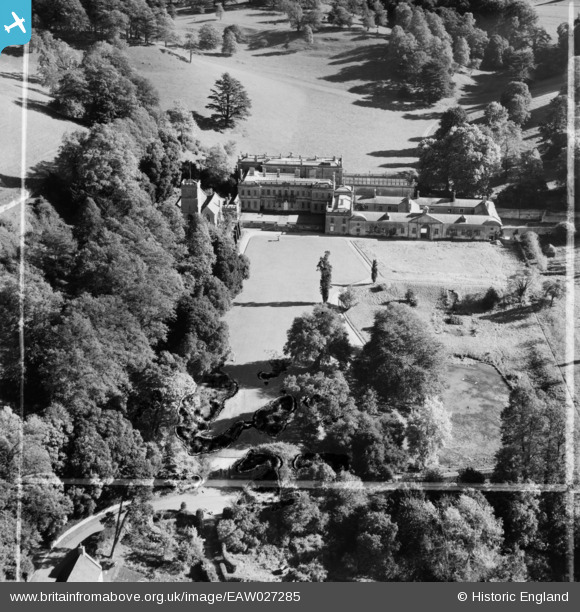
EAW027285 ENGLAND (1949). Dyrham House and Park, Dyrham, 1949. This image was marked by Aerofilms Ltd for photo editing.
© Copyright OpenStreetMap contributors and licensed by the OpenStreetMap Foundation. 2024. Cartography is licensed as CC BY-SA.
Nearby Images (5)
Details
Title | [EAW027285] Dyrham House and Park, Dyrham, 1949. This image was marked by Aerofilms Ltd for photo editing. |
Reference | EAW027285 |
Date | 19-October-1949 |
Link | |
Place name | DYRHAM |
Parish | DYRHAM AND HINTON |
District | |
Country | ENGLAND |
Easting / Northing | 374093, 175777 |
Longitude / Latitude | -2.3731032702138, 51.479870157902 |
National Grid Reference | ST741758 |
Pins
Upper Street |
totoro |
Friday 11th of April 2014 06:12:12 PM |
Stable Block Attached to South of Dyrham House, Dyrham and Hinton
Grade 1 listed - English Heritage Building ID: 396555
Stable block. 1698, to designs by William Talman, probably largely supervised by Edward Wilcox, foreman; garret storey removed C19. West elevation in very fine coursed freestone, stone dressings, rubble to east, slate roofs with weathered
ridge stacks. Built around 2 courtyards. West elevation of tall single storey. |
totoro |
Friday 11th of April 2014 06:10:30 PM |
Small Cascade and 2 Lakes About 50 Metres West of Stable Block Attached to South of Dyrham House, Dyrham and Hinton
Grade 1 listed - English Heritage Building ID: 396555
Small cascade and surrounds to 2 lakes. Late C17/early C18 origin, with later alterations. Limestone. Flight of 15 rusticated stone steps about 2 metres wide, channelling water into a rectangular pool about 10 metres by 18 metres with coursed rubble walls and freestone at west wall, water channelled into lower lake about 14 metres west, also with rubble walls and shaped ends east and west, about 30 metres by 60 metres. Cascade and lakes shown on Kip's view of Dyrham and the water garden of 1712; the lakes may have been reduced in size since that date |
totoro |
Friday 11th of April 2014 06:06:26 PM |
Small cascade leading to small straight edged pond (somewhat dried up and overgrown in this image - today it is in better condition) |
totoro |
Friday 11th of April 2014 06:04:26 PM |
Plinth and Urn About 30 Metres West of Dyrham House, Dyrham and Hinton.
Grade 2 listed - English Heritage Building ID: 396551
Plinth and urn. C18. Limestone. Square plinth on moulded base |
totoro |
Friday 11th of April 2014 06:01:11 PM |
Orangery Attached to South East of Dyrham House, Dyrham and Hinton
Grade 1 listed - English Heritage Building ID: 396553
Orangery (known as greenhouse in C17). Started in 1701 by William Talman, front slope of roof glazed c. 1800 by Repton. |
totoro |
Friday 11th of April 2014 05:59:36 PM |
Balustrade, Wall and Stair About 18 Metres West of Dyrham House, Dyrham and Hinton
Grade 2 listed - English Heritage Building ID: 396550
Balustrade, wall and stair forming boundary of forecourt to west of Dyrham House. c. 1695. Limestone, ashlar walls. Wall about 30 metres long, in 2 sections to either side of central stairway |
totoro |
Friday 11th of April 2014 05:55:01 PM |
DYRHAM HOUSE Hinton, South Gloucestershire SN14 8HW
Several listed features in the area.
The House- Grade 1 listed building - English Heritage Building ID: 396548
Designed by Talman for William Blathwayt, Secretary at War during the reign of William III.
17th-century mansion, garden and deer park - National Trust- paid entry.
West front by Samuel Hauduroy, completed by 1694, east front by William Talman, completed by 1703
Enlarged C19, east front extending to north and south beyond central block
In 1938, Dyrham's then owner, Christopher Blathwayt, let the house to Lady Islington, widow of a local MP. During the War, Lady Islington turned Dyrham into a nursery for evacuees, preventing the army from moving in. When she left in 1946, Dyrham's survival looked bleak. But its importance was recognised in 1956, when the National Land Fund bought Dyrham and its contents.
After extensive repairs, Dyrham was handed to the National Trust in 1961 to be cared for and opened to the public. The acquisition was completed in 1976 when the historic 272-acre deer park was purchased with a grant from the National Heritage Memorial Fund.
The nearby church with its private entrance for the house owner, is also a listed building as are a number of external monuments in the church grounds. |
totoro |
Friday 11th of April 2014 05:42:10 PM |
Church of St Peter, Dyrham and Hinton - Upper Street, Hinton, South Gloucestershire SN14 8HW
Grade 1 listed church - English Heritage Building ID: 396537
Many outside monuments are separately listed.
Parish church. Mid C13 origin, early C15 tower and porch, altered c.1470, south aisle restored for William Blathwayt after 1688, redecorated 1964 by E.F. Tew.
|
totoro |
Friday 11th of April 2014 05:41:51 PM |
User Comment Contributions
View is facing towards the East |
totoro |
Friday 11th of April 2014 05:52:40 PM |
Copyright Image by Becks taken September 2012. Shows the house with the church behind it (on the right). Used with permission under licence: Creative Commons Attirbution Vn 2 Source: https://commons.wikimedia.org/wiki/ File:Dyrham_Park_(7963798162).jpg |
totoro |
Friday 11th of April 2014 05:50:46 PM |
Copyright Image by Rwendland used under licence. Date taken November 2010. Shows church and house. License - Creative Commons Attribution Share-Alike Unported Vn 3.0 (and also alternately GNU Free Documentation License, Version 1.2) Source: https://commons.wikimedia.org/wiki/ File:Dyrham_Park,_house_and_church,_from_lawn.jpg |
totoro |
Friday 11th of April 2014 05:46:59 PM |
Dyrham House 9/3/2014 |
Class31 |
Monday 10th of March 2014 09:44:32 AM |
Dyrham House 9/3/2014 |
Class31 |
Monday 10th of March 2014 09:43:40 AM |
Dyrham House 9/3/2014 |
Class31 |
Monday 10th of March 2014 09:42:04 AM |