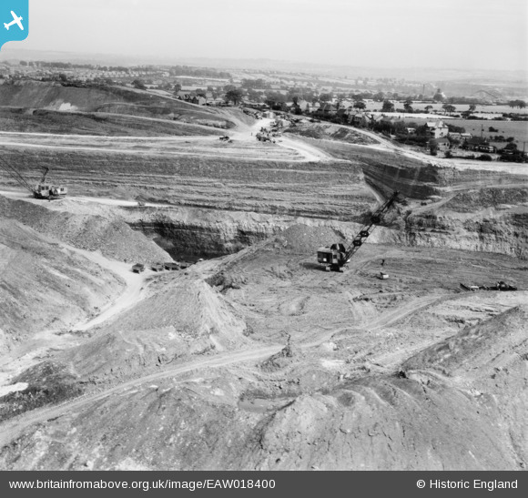
EAW018400 ENGLAND (1948). An opencast mining site to the north of the village, Smalley, from the west, 1948
© Copyright OpenStreetMap contributors and licensed by the OpenStreetMap Foundation. 2024. Cartography is licensed as CC BY-SA.
Nearby Images (48)
Details
| Title | [EAW018400] An opencast mining site to the north of the village, Smalley, from the west, 1948 |
| Reference | EAW018400 |
| Date | 31-August-1948 |
| Link | |
| Place name | SMALLEY |
| Parish | SMALLEY |
| District | |
| Country | ENGLAND |
| Easting / Northing | 441316, 345681 |
| Longitude / Latitude | -1.3842018674702, 53.006538796836 |
| National Grid Reference | SK413457 |
Pins
 Class31 |
Thursday 9th of January 2014 01:43:35 PM |


![[EAW018400] An opencast mining site to the north of the village, Smalley, from the west, 1948](http://britainfromabove.org.uk/sites/all/libraries/aerofilms-images/public/100x100/EAW/018/EAW018400.jpg)
![[EAW025916] An opencast mining site adjacent to Heanor Road, Smalley, from the north-west, 1949](http://britainfromabove.org.uk/sites/all/libraries/aerofilms-images/public/100x100/EAW/025/EAW025916.jpg)
![[EAW017964] Opencast coal mining to the north of Carrington's Farm, Smalley, 1948. This image has been produced from a damaged negative.](http://britainfromabove.org.uk/sites/all/libraries/aerofilms-images/public/100x100/EAW/017/EAW017964.jpg)
![[EAW025914] An opencast mining site to the north of the village, Smalley, 1949](http://britainfromabove.org.uk/sites/all/libraries/aerofilms-images/public/100x100/EAW/025/EAW025914.jpg)
![[EAW012044] Opencast mining site to the north of the village, Smalley, 1947. This image was marked by Aerofilms Ltd for photo editing.](http://britainfromabove.org.uk/sites/all/libraries/aerofilms-images/public/100x100/EAW/012/EAW012044.jpg)
![[EAW012041] Opencast mining site to the north of the village, Smalley, 1947. This image was marked by Aerofilms Ltd for photo editing.](http://britainfromabove.org.uk/sites/all/libraries/aerofilms-images/public/100x100/EAW/012/EAW012041.jpg)
![[EAW012042] Opencast mining site to the north of the village, Smalley, 1947. This image was marked by Aerofilms Ltd for photo editing.](http://britainfromabove.org.uk/sites/all/libraries/aerofilms-images/public/100x100/EAW/012/EAW012042.jpg)
![[EAW025921] An opencast mining site adjacent to Heanor Road, Smalley, 1949. This image has been produced from a print.](http://britainfromabove.org.uk/sites/all/libraries/aerofilms-images/public/100x100/EAW/025/EAW025921.jpg)
![[EAW011889] Opencast mining site to the north of the village, Smalley, 1947](http://britainfromabove.org.uk/sites/all/libraries/aerofilms-images/public/100x100/EAW/011/EAW011889.jpg)
![[EAW011891] Opencast mining site to the north of the village, Smalley, 1947. This image was marked by Aerofilms Ltd for photo editing.](http://britainfromabove.org.uk/sites/all/libraries/aerofilms-images/public/100x100/EAW/011/EAW011891.jpg)
![[EAW012047] Opencast mining site to the north of the village, Smalley, 1947](http://britainfromabove.org.uk/sites/all/libraries/aerofilms-images/public/100x100/EAW/012/EAW012047.jpg)
![[EAW011890] Opencast mining site to the north of the village, Smalley, 1947. This image was marked by Aerofilms Ltd for photo editing.](http://britainfromabove.org.uk/sites/all/libraries/aerofilms-images/public/100x100/EAW/011/EAW011890.jpg)
![[EAW011894] Opencast mining site to the north of the village, Smalley, 1947. This image was marked by Aerofilms Ltd for photo editing.](http://britainfromabove.org.uk/sites/all/libraries/aerofilms-images/public/100x100/EAW/011/EAW011894.jpg)
![[EAW011893] Opencast mining site to the north of the village, Smalley, 1947. This image was marked by Aerofilms Ltd for photo editing.](http://britainfromabove.org.uk/sites/all/libraries/aerofilms-images/public/100x100/EAW/011/EAW011893.jpg)
![[EAW011892] Opencast mining site adjacent to Kidsleypark Farm, Smalley, 1947. This image was marked by Aerofilms Ltd for photo editing.](http://britainfromabove.org.uk/sites/all/libraries/aerofilms-images/public/100x100/EAW/011/EAW011892.jpg)
![[EAW011252] Opencast coal mining to the west of Kidsleypark Farm, Smalley, 1947](http://britainfromabove.org.uk/sites/all/libraries/aerofilms-images/public/100x100/EAW/011/EAW011252.jpg)
![[EAW012040] Opencast mining site to the north of the village, Smalley, 1947. This image was marked by Aerofilms Ltd for photo editing.](http://britainfromabove.org.uk/sites/all/libraries/aerofilms-images/public/100x100/EAW/012/EAW012040.jpg)
![[EAW011238] Opencast coal mining to the north of Carrington's Farm, Smalley, 1947](http://britainfromabove.org.uk/sites/all/libraries/aerofilms-images/public/100x100/EAW/011/EAW011238.jpg)
![[EAW011900] Opencast mining site adjacent to Kidsleypark Farm, Smalley, 1947](http://britainfromabove.org.uk/sites/all/libraries/aerofilms-images/public/100x100/EAW/011/EAW011900.jpg)
![[EAW017960] Opencast coal mining to the north of Carrington's Farm, Smalley, 1948](http://britainfromabove.org.uk/sites/all/libraries/aerofilms-images/public/100x100/EAW/017/EAW017960.jpg)
![[EAW025927] An opencast mining site adjacent to Heanor Road, Smalley, 1949](http://britainfromabove.org.uk/sites/all/libraries/aerofilms-images/public/100x100/EAW/025/EAW025927.jpg)
![[EAW017986] Opencast coal mining, Smalley, 1948. This image has been produced from a print.](http://britainfromabove.org.uk/sites/all/libraries/aerofilms-images/public/100x100/EAW/017/EAW017986.jpg)
![[EAW012039] Opencast mining site to the north of the village, Smalley, 1947. This image was marked by Aerofilms Ltd for photo editing.](http://britainfromabove.org.uk/sites/all/libraries/aerofilms-images/public/100x100/EAW/012/EAW012039.jpg)
![[EAW011895] Opencast mining site to the north of the village, Smalley, 1947](http://britainfromabove.org.uk/sites/all/libraries/aerofilms-images/public/100x100/EAW/011/EAW011895.jpg)
![[EAW011899] Opencast mining site adjacent to Kidsleypark Farm, Smalley, 1947](http://britainfromabove.org.uk/sites/all/libraries/aerofilms-images/public/100x100/EAW/011/EAW011899.jpg)
![[EAW025926] An opencast mining site adjacent to Heanor Road, Smalley, 1949](http://britainfromabove.org.uk/sites/all/libraries/aerofilms-images/public/100x100/EAW/025/EAW025926.jpg)
![[EAW018404] An opencast mining site to the north of the village, Smalley, 1948](http://britainfromabove.org.uk/sites/all/libraries/aerofilms-images/public/100x100/EAW/018/EAW018404.jpg)
![[EAW011896] Opencast mining site adjacent to Kidsleypark Farm, Smalley, 1947. This image was marked by Aerofilms Ltd for photo editing.](http://britainfromabove.org.uk/sites/all/libraries/aerofilms-images/public/100x100/EAW/011/EAW011896.jpg)
![[EAW018399] A crane and truck at an opencast mining site to the north of the village, Smalley, 1948](http://britainfromabove.org.uk/sites/all/libraries/aerofilms-images/public/100x100/EAW/018/EAW018399.jpg)
![[EAW011898] Opencast mining site adjacent to Kidsleypark Farm, Smalley, 1947. This image was marked by Aerofilms Ltd for photo editing.](http://britainfromabove.org.uk/sites/all/libraries/aerofilms-images/public/100x100/EAW/011/EAW011898.jpg)
![[EAW025918] An opencast mining site adjacent to Heanor Road, Smalley, 1949](http://britainfromabove.org.uk/sites/all/libraries/aerofilms-images/public/100x100/EAW/025/EAW025918.jpg)
![[EAW011897] Opencast mining site adjacent to Kidsleypark Farm, Smalley, 1947](http://britainfromabove.org.uk/sites/all/libraries/aerofilms-images/public/100x100/EAW/011/EAW011897.jpg)
![[EAW018398] A Rapier crane at an opencast mining site to the north of the village, Smalley, 1948](http://britainfromabove.org.uk/sites/all/libraries/aerofilms-images/public/100x100/EAW/018/EAW018398.jpg)
![[EAW018403] An opencast mining site to the north of the village, Smalley, 1948](http://britainfromabove.org.uk/sites/all/libraries/aerofilms-images/public/100x100/EAW/018/EAW018403.jpg)
![[EAW018405] An opencast mining site to the north of the village, Smalley, 1948](http://britainfromabove.org.uk/sites/all/libraries/aerofilms-images/public/100x100/EAW/018/EAW018405.jpg)
![[EAW012048] Opencast mining site to the north of the village, Smalley, 1947](http://britainfromabove.org.uk/sites/all/libraries/aerofilms-images/public/100x100/EAW/012/EAW012048.jpg)
![[EAW017963] Opencast coal mining to the north of Carrington's Farm, Smalley, 1948. This image has been produced from a damaged negative.](http://britainfromabove.org.uk/sites/all/libraries/aerofilms-images/public/100x100/EAW/017/EAW017963.jpg)
![[EAW011243] Opencast coal mining to the north of Carrington's Farm, Smalley, 1947](http://britainfromabove.org.uk/sites/all/libraries/aerofilms-images/public/100x100/EAW/011/EAW011243.jpg)
![[EAW033473] Restored opencast mining site near Carrington's Farm, Flamstead Plantation and environs, Denby Village, 1950](http://britainfromabove.org.uk/sites/all/libraries/aerofilms-images/public/100x100/EAW/033/EAW033473.jpg)
![[EAW011226] Opencast coal mining to the north of Heanor Road, Denby Village, 1947](http://britainfromabove.org.uk/sites/all/libraries/aerofilms-images/public/100x100/EAW/011/EAW011226.jpg)
![[EAW025912] An opencast mining site adjacent to Heanor Road, Smalley, 1949](http://britainfromabove.org.uk/sites/all/libraries/aerofilms-images/public/100x100/EAW/025/EAW025912.jpg)
![[EAW025924] An opencast mining site adjacent to Heanor Road, Smalley, 1949. This image has been produced from a print.](http://britainfromabove.org.uk/sites/all/libraries/aerofilms-images/public/100x100/EAW/025/EAW025924.jpg)
![[EAW018415] An opencast mining site to the north of the village, Smalley, from the north-west, 1948](http://britainfromabove.org.uk/sites/all/libraries/aerofilms-images/public/100x100/EAW/018/EAW018415.jpg)
![[EAW033474] Restored opencast mining site near Carrington's Farm, Denby Village, 1950](http://britainfromabove.org.uk/sites/all/libraries/aerofilms-images/public/100x100/EAW/033/EAW033474.jpg)
![[EAW012052] Opencast mining site to the north of the village, Smalley, 1947](http://britainfromabove.org.uk/sites/all/libraries/aerofilms-images/public/100x100/EAW/012/EAW012052.jpg)
![[EAW011236] Opencast coal mining to the north of Carrington's Farm, Smalley, 1947](http://britainfromabove.org.uk/sites/all/libraries/aerofilms-images/public/100x100/EAW/011/EAW011236.jpg)
![[EAW017958] Opencast coal mining to the north of Carrington's Farm, Denby Village, 1948. This image has been produced from a damaged negative.](http://britainfromabove.org.uk/sites/all/libraries/aerofilms-images/public/100x100/EAW/017/EAW017958.jpg)
![[EAW011235] Opencast coal mining to the north of Carrington's Farm, Smalley, 1947](http://britainfromabove.org.uk/sites/all/libraries/aerofilms-images/public/100x100/EAW/011/EAW011235.jpg)


