
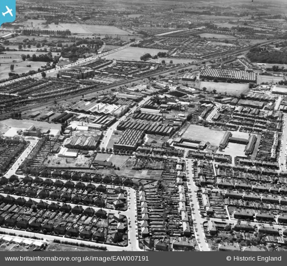
EAW007191 ENGLAND (1947). The Perivale Industrial Park, Perivale, 1947
© Copyright OpenStreetMap contributors and licensed by the OpenStreetMap Foundation. 2024. Cartography is licensed as CC BY-SA.
Nearby Images (5)
EAW007191

EAW007189

EPR000614

EPW040835

EPW035534

Details
| Title | [EAW007191] The Perivale Industrial Park, Perivale, 1947 |
| Reference | EAW007191 |
| Date | June-1947 |
| Link | |
| Place name | PERIVALE |
| Parish | |
| District | |
| Country | ENGLAND |
| Easting / Northing | 517211, 183302 |
| Longitude / Latitude | -0.3098430166185, 51.535957962103 |
| National Grid Reference | TQ172833 |
Pins
 The Laird |
Wednesday 14th of September 2022 08:53:02 PM | |
 Des Elmes |
Saturday 29th of May 2021 01:36:54 AM | |
Des Elmes |
Saturday 29th of May 2021 01:35:31 AM | |
Des Elmes |
Saturday 29th of May 2021 01:31:46 AM | |
Des Elmes |
Saturday 29th of May 2021 01:28:36 AM | |
Des Elmes |
Saturday 29th of May 2021 01:25:06 AM | |
Des Elmes |
Saturday 29th of May 2021 01:22:48 AM | |
Des Elmes |
Saturday 29th of May 2021 01:21:40 AM | |
Des Elmes |
Saturday 29th of May 2021 01:20:32 AM | |
Efkay |
Monday 2nd of November 2020 03:55:26 AM | |
Efkay |
Monday 2nd of November 2020 03:51:24 AM | |
Efkay |
Monday 2nd of November 2020 03:49:20 AM | |
Sparky |
Tuesday 3rd of October 2017 10:05:27 PM |


