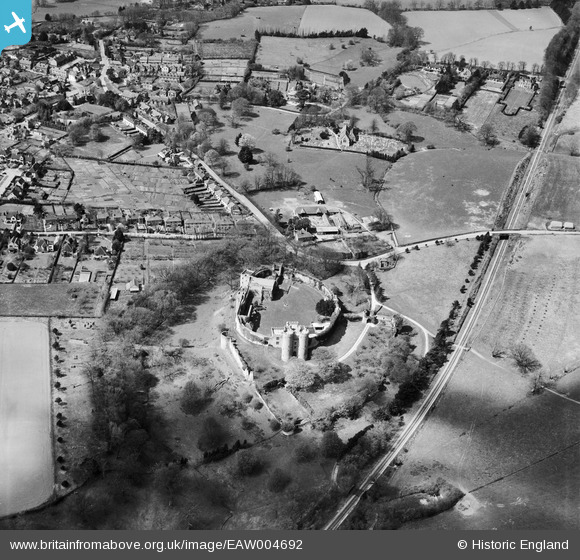
EAW004692 ENGLAND (1947). Saltwood Castle, Saltwood, 1947

© Copyright OpenStreetMap contributors and licensed by the OpenStreetMap Foundation. 2024. Cartography is licensed as CC BY-SA.

Nearby Images (13)

EAW004692
  0° 0m
EAW004693
  124° 59m
EAW006153
  75° 65m
EAW006154
  86° 72m
EAW006155
  89° 77m
EAW006152
  81° 80m
EAW006156
  111° 91m
EAW004694
  98° 106m
EAW004691
  55° 117m
EAW004690
  69° 120m
EAW002870
  43° 121m
EAW002869
  63° 158m
EAW004689
  105° 173m

Details

Title [EAW004692] Saltwood Castle, Saltwood, 1947
Reference EAW004692
Date 26-April-1947
Link
Place name SALTWOOD
Parish SALTWOOD
District
Country ENGLAND
Easting / Northing 616062, 135921
Longitude / Latitude 1.0851442521835, 51.081326699005
National Grid Reference TR161359

Pins

The Castle Pub

Paolo
Saturday 7th of December 2013 04:27:46 PM
Saltwood Castle Grade 1 listed building English Heritage Building ID: 175639. Post code CT21 4QU. In private ownership, no general public access. The present castle stands on the site of earlier castles, the first one being reported to have been constructed in 488 Castle. Largely ruinous. Core of inner curtain wall C12 (or possibly C11). Rest C12, C13 and C14. Late C14 work by Archbishop Courtenay. Archbishop Lanfranc took Saltwood into his personal possession in 1086; it apparently remained the property of the archbishops for much of the Middle Ages. Murder of Thomas a Becket said to have been planned here (1170)- at the time the Castle was in the hands of Runulf de Broc and Thomas was seeking the return of the Castle to the Church. The square towers of the inner ward probably date from around 1160 and the round towers of the outer ward or barbican are 14th century. The arms of Archbishop Courtney distinguish the great gatehouse built when he made the castle his chief residence from 1382. 1385 extension to gatehouse Probably ruined by earthquake in 1580. Restoration and additions of 1880s by F. Beeston, and by Philip Tilden in 1930s. Somewhat protected in WW2 as Hermann Goering wished to use the castle post-invasion.

totoro
Sunday 27th of October 2013 09:18:58 PM

totoro
Sunday 27th of October 2013 09:05:00 PM

totoro
Sunday 27th of October 2013 09:02:58 PM

totoro
Sunday 27th of October 2013 09:02:16 PM

totoro
Sunday 27th of October 2013 09:01:57 PM

totoro
Sunday 27th of October 2013 09:00:46 PM
Saltwood House, Grade 2 listed building, English Heritage Building ID: 175649 Rectory, now house. 1770 by the Rev. Thomas Randolph, with medieval core and early C19 additions. The driveway retains the shape shown here but the large tree in front of the house has gone, giving it a more open view.

totoro
Sunday 27th of October 2013 08:59:53 PM
St Peter and Saint Paul, Grade 2* listed building, English Heritage Building ID: 175645 Parish church. Late C11 or C12, C13, C14, restored late C19. Chancel: C14; West Tower: C13, Nave: Late C11 or C12.

totoro
Sunday 27th of October 2013 08:53:45 PM
Railway line. Formerly a branch line with Sanderling to the top of the image and Sandgate to the bottom. At Sanderling the line joins the Ashford-Folkestone line which remains in use. In 1931 the track here was made single track and to the bottom of the image was curtailed to Hythe. This railway line was closed in 1951.

totoro
Sunday 27th of October 2013 08:49:05 PM
Sandling Station, not Sanderling

Paolo
Saturday 7th of December 2013 04:25:25 PM
"Sanderling" should read "Sandling Junction" and later after the branch line closed the station was renamed "Sandling for Hythe"


I recall the line fully working from 1949 to 1951.

PVPM
Friday 28th of February 2014 01:46:25 PM
Further information about Sandling Junction station and the branch line can be found at http://www.disused-stations.org.uk/s/sandling_junction/index.shtml

John W
Sunday 29th of January 2017 05:31:24 PM