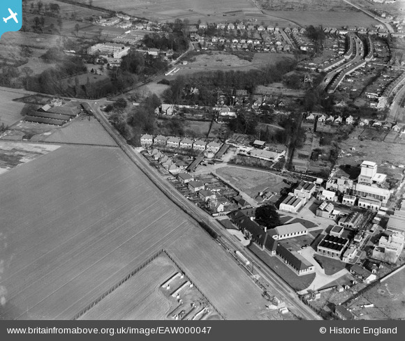
EAW000047 ENGLAND (1946). The Anglo-Iranian Oil Co (British Petroleum) Research Laboratory and the surrounding residential area, Ashford Common, 1946
© Copyright OpenStreetMap contributors and licensed by the OpenStreetMap Foundation. 2024. Cartography is licensed as CC BY-SA.
Nearby Images (30)
Details
| Title | [EAW000047] The Anglo-Iranian Oil Co (British Petroleum) Research Laboratory and the surrounding residential area, Ashford Common, 1946 |
| Reference | EAW000047 |
| Date | 25-March-1946 |
| Link | |
| Place name | ASHFORD COMMON |
| Parish | |
| District | |
| Country | ENGLAND |
| Easting / Northing | 509249, 170936 |
| Longitude / Latitude | -0.42843123303798, 51.426395642581 |
| National Grid Reference | TQ092709 |


![[EAW000047] The Anglo-Iranian Oil Co (British Petroleum) Research Laboratory and the surrounding residential area, Ashford Common, 1946](http://britainfromabove.org.uk/sites/all/libraries/aerofilms-images/public/100x100/EAW/000/EAW000047.jpg)
![[EAW000049] The Anglo-Iranian Oil Co (British Petroleum) Research Laboratory and the surrounding residential area, Ashford Common, 1946](http://britainfromabove.org.uk/sites/all/libraries/aerofilms-images/public/100x100/EAW/000/EAW000049.jpg)
![[EAW000012] Buildings on the south side of Chertsey Road, Ashford Common, 1946](http://britainfromabove.org.uk/sites/all/libraries/aerofilms-images/public/100x100/EAW/000/EAW000012.jpg)
![[EAW000045] The Anglo-Iranian Oil Co (British Petroleum) Research Laboratory and the surrounding residential area, Ashford Common, 1946](http://britainfromabove.org.uk/sites/all/libraries/aerofilms-images/public/100x100/EAW/000/EAW000045.jpg)
![[EAW017552] The Anglo-Iranian Oil Company (AIOC) Research Station, Ashford Common, 1948. This image has been produced from a print.](http://britainfromabove.org.uk/sites/all/libraries/aerofilms-images/public/100x100/EAW/017/EAW017552.jpg)
![[EPW056785] The Anglo-Iranian Oil Co (British Petroleum) Research Laboratory, Ashford Common, 1938](http://britainfromabove.org.uk/sites/all/libraries/aerofilms-images/public/100x100/EPW/056/EPW056785.jpg)
![[EAW000011] Chertsey Road, Ashford Common, 1946](http://britainfromabove.org.uk/sites/all/libraries/aerofilms-images/public/100x100/EAW/000/EAW000011.jpg)
![[EAW017549] The Anglo-Iranian Oil Company (AIOC) Research Station, Ashford Common, 1948. This image has been produced from a print.](http://britainfromabove.org.uk/sites/all/libraries/aerofilms-images/public/100x100/EAW/017/EAW017549.jpg)
![[EPW056782] The Anglo-Iranian Oil Co (British Petroleum) Research Laboratory and the Meadhurst Park Nursery, Ashford Common, 1938. This image has been affected by flare.](http://britainfromabove.org.uk/sites/all/libraries/aerofilms-images/public/100x100/EPW/056/EPW056782.jpg)
![[EPW056784] The Anglo-Iranian Oil Co (British Petroleum) Research Laboratory, the Meadhurst Park Nursery and surroundings, Ashford Common, 1938. This image has been produced from a damaged negative.](http://britainfromabove.org.uk/sites/all/libraries/aerofilms-images/public/100x100/EPW/056/EPW056784.jpg)
![[EPW056779] The Anglo-Iranian Oil Co (British Petroleum) Research Laboratory and surroundings, Ashford Common, 1938](http://britainfromabove.org.uk/sites/all/libraries/aerofilms-images/public/100x100/EPW/056/EPW056779.jpg)
![[EAW000046] The Anglo-Iranian Oil Co (British Petroleum) Research Laboratory and the Meadhurst Park Nursery, Ashford Common, 1946](http://britainfromabove.org.uk/sites/all/libraries/aerofilms-images/public/100x100/EAW/000/EAW000046.jpg)
![[EPW056781] The Anglo-Iranian Oil Co (British Petroleum) Research Laboratory and the Meadhurst Park Nursery, Ashford Common, 1938](http://britainfromabove.org.uk/sites/all/libraries/aerofilms-images/public/100x100/EPW/056/EPW056781.jpg)
![[EAW017551] The Anglo-Iranian Oil Company (AIOC) Research Station, Ashford Common, 1948. This image has been produced from a print.](http://britainfromabove.org.uk/sites/all/libraries/aerofilms-images/public/100x100/EAW/017/EAW017551.jpg)
![[EAW017560] The Anglo-Iranian Oil Company (AIOC) Research Station, Ashford Common, 1948. This image has been produced from a damaged negative.](http://britainfromabove.org.uk/sites/all/libraries/aerofilms-images/public/100x100/EAW/017/EAW017560.jpg)
![[EPW056780] The Anglo-Iranian Oil Co (British Petroleum) Research Laboratory and the Meadhurst Park Nursery, Ashford Common, 1938](http://britainfromabove.org.uk/sites/all/libraries/aerofilms-images/public/100x100/EPW/056/EPW056780.jpg)
![[EAW017555] The Anglo-Iranian Oil Company (AIOC) Research Station, Ashford Common, 1948. This image has been produced from a print.](http://britainfromabove.org.uk/sites/all/libraries/aerofilms-images/public/100x100/EAW/017/EAW017555.jpg)
![[EAW000014] Buildings on the south side of Chertsey Road, Ashford Common, 1946](http://britainfromabove.org.uk/sites/all/libraries/aerofilms-images/public/100x100/EAW/000/EAW000014.jpg)
![[EPW056783] The Anglo-Iranian Oil Co (British Petroleum) Research Laboratory and the Meadhurst Park Nursery, Ashford Common, 1938](http://britainfromabove.org.uk/sites/all/libraries/aerofilms-images/public/100x100/EPW/056/EPW056783.jpg)
![[EAW017559] The Anglo-Iranian Oil Company (AIOC) Research Station, Ashford Common, 1948. This image has been produced from a damaged negative.](http://britainfromabove.org.uk/sites/all/libraries/aerofilms-images/public/100x100/EAW/017/EAW017559.jpg)
![[EAW017554] The Anglo-Iranian Oil Company (AIOC) Research Station, Ashford Common, 1948. This image has been produced from a print.](http://britainfromabove.org.uk/sites/all/libraries/aerofilms-images/public/100x100/EAW/017/EAW017554.jpg)
![[EAW000013] Buildings on the south side of Chertsey Road, Ashford Common, 1946](http://britainfromabove.org.uk/sites/all/libraries/aerofilms-images/public/100x100/EAW/000/EAW000013.jpg)
![[EAW017556] The Anglo-Iranian Oil Company (AIOC) Research Station and environs, Ashford Common, 1948. This image has been produced from a print.](http://britainfromabove.org.uk/sites/all/libraries/aerofilms-images/public/100x100/EAW/017/EAW017556.jpg)
![[EAW017553] The Anglo-Iranian Oil Company (AIOC) Research Station, Ashford Common, 1948. This image has been produced from a print.](http://britainfromabove.org.uk/sites/all/libraries/aerofilms-images/public/100x100/EAW/017/EAW017553.jpg)
![[EAW000015] Buildings on the south side of Chertsey Road, Ashford Common, 1946](http://britainfromabove.org.uk/sites/all/libraries/aerofilms-images/public/100x100/EAW/000/EAW000015.jpg)
![[EAW017548] The Anglo-Iranian Oil Company (AIOC) Research Station, Ashford Common, 1948. This image has been produced from a print.](http://britainfromabove.org.uk/sites/all/libraries/aerofilms-images/public/100x100/EAW/017/EAW017548.jpg)
![[EAW017557] The Anglo-Iranian Oil Company (AIOC) Research Station, Ashford Common, 1948. This image has been produced from a print.](http://britainfromabove.org.uk/sites/all/libraries/aerofilms-images/public/100x100/EAW/017/EAW017557.jpg)
![[EAW017550] The Anglo-Iranian Oil Company (AIOC) Research Station, Ashford Common, 1948. This image has been produced from a print.](http://britainfromabove.org.uk/sites/all/libraries/aerofilms-images/public/100x100/EAW/017/EAW017550.jpg)
![[EAW017558] The Anglo-Iranian Oil Company (AIOC) Research Station, Ashford Common, 1948. This image has been produced from a print.](http://britainfromabove.org.uk/sites/all/libraries/aerofilms-images/public/100x100/EAW/017/EAW017558.jpg)
![[EPW056786] The Anglo-Iranian Oil Co (British Petroleum) Research Laboratory and Meadhurst Park Nursery , Ashford Common, 1938](http://britainfromabove.org.uk/sites/all/libraries/aerofilms-images/public/100x100/EPW/056/EPW056786.jpg)


