Bishop Blaize : PUB |

Scooby |
Saturday 2nd of May 2020 04:06:04 PM |
Coombe Street |

Allen T |
Wednesday 30th of July 2014 05:14:57 PM |
West Street |
Allen T |
Wednesday 30th of July 2014 05:14:28 PM |
Shooting Marsh Stile |
Allen T |
Wednesday 30th of July 2014 05:01:16 PM |
Great Shillhay |
Allen T |
Wednesday 30th of July 2014 04:57:40 PM |
Haven Nurseries |
Allen T |
Wednesday 30th of July 2014 04:56:13 PM |
Haven Road |
Allen T |
Wednesday 30th of July 2014 04:55:41 PM |
Mermaid's Yard. |
Allen T |
Sunday 17th of November 2013 10:53:31 PM |
View looking up Preston Street towards the Cathedral. There are few historic buildings in shot(apart from the Cathedral). |

Class31 |
Thursday 20th of June 2013 10:21:41 AM |
City Walls in this area. |
Class31 |
Thursday 20th of June 2013 10:15:40 AM |
Cricklepit Mill |
Class31 |
Thursday 20th of June 2013 10:14:10 AM |
Cricklepit Mill |
Isleworth1961 |
Saturday 8th of June 2013 10:35:31 PM |
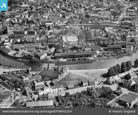
A sooted chimney belching out thick black smoke. A practice that was only halted by the Clean Air Act some twenty years later. |
Allen T |
Monday 20th of May 2013 12:13:52 AM |
The River Exe, renowned in ancient times for its plentiful supply of fish. An essential component in the birth of Exeter and a working river for some two thousand years. |
Allen T |
Monday 20th of May 2013 12:11:30 AM |
Gabriel, Wade and English were timber importers.From the early 19th century the works were based at Barnard's Wharf, 341 Rotherhithe Street, Rotherhithe. Until 1930 the family held Gabriel's Wharf, Commercial Road, Lambeth, on a long lease from the Duchy of Cornwall. There was also a branch yard at Exeter. By 1937 branch offices had been established in Hull, Wisbech, Ipswich, Southampton, Exeter, Bedford, Leicester, Cambridge, Peterborough and Scarborough. |
Allen T |
Sunday 19th of May 2013 11:46:10 PM |
Preston Street "the street of the Priests". This street has been so named for 800 years although most of the original properties of historic interest no longer exist and the street itself is a pale shadow of its historic past. |
Allen T |
Sunday 19th of May 2013 05:07:59 PM |
St Mary Steps Church |
Allen T |
Tuesday 14th of May 2013 07:53:40 PM |
This church, St Mary Major, St David's and various non-conformist chapels was the religious centre of my family from 1740 to 1930. Like many other local families, in the course of almost 200 years ten generations of my family only lived in four parishes all within a one mile square area in Exeter. |
Allen T |
Thursday 11th of July 2013 12:58:21 PM |
St Edmund's Church built on the original Exe Bridge.
The original church, constructed on reclaimed land from the river, probably dated from around about 870. King Edmund 849-870 had many chapels dedicated to him at this time, so a Saxon church on a possible Roman or Saxon ford may date from this period. St Edmund's was one of the chapels mentioned by Peter de Palerna in his will during the reign of King John (1199-1216). He left the sum of 1 penny per year to each of 28 chapels, including St Edmund's.
Walter Gervase had the Exe bridge constructed from 1190, incorporating a newly built chapel of St Edmund's, replacing the old structure. Gervase was Mayor of Exeter in 1231 and 1239 and was buried along with his wife, in a small chantry chapel built on the bridge opposite St Edmund's. In 1833, this small chapel was removed and the bones of a tall man were found under the floor, to be re-interred in the same spot, under one of the piers of the bridge he had built. St Edmund's itself has also been referred to as St Edmund's on the Bridge and even the Chantry on the Bridge.
Printing press
It is thought that Exeter's first printing press was installed in the church by John Williams the rector from 1554 to 1572, with a press supplied by Tavistock Abbey. In 1800, the tower was extensively damaged by lightning - an etching for Thomas Shapter's History of Cholera shows a pointed spire on top of the tower in 1832.
In 1834, extensive repairs were undertaken and the church was rebuilt at a cost of £2,000. It was a cement rendered structure, using material from the old church, with most of the original tower retained, and a peal of eight bells; the treble, fifth and tenor were dated 1833, while the remaining five dated from 1731. Internally the church had an altar screen presented by Lord Rolle, and choir screens were installed in 1888. The register of baptisms and burials date from 1571 and marriages from 1572.
The remains of St Edmund's
The Parish of St Edmunds stretched from the ancient bridge, across Exe Island and Bonhay, almost to Head Weir with its north western boundary under the walls of Exeter. The population of St Edmunds in 1801 was 918, which increased considerably during the 19th Century as industrialisation spread across the area.
The church was damaged by fire in 1969. The traffic scheme of the 1960's and 70's that created Western Way required the demolition of many properties in Edmund Street - the partially demolished church was reprieved when the remains of the old Exe bridge were discovered and excavated by archaeologists during 1975. However, the demolition had already been extensive and only part of the church tower remains, perched on the mediaeval bridge
|
Allen T |
Tuesday 14th of May 2013 06:19:45 PM |
Stepcote Hill, Exeter's oldest street. |
Allen T |
Tuesday 14th of May 2013 04:30:29 PM |
Horse drawing a commercial carriage. Rag and bone man? We had a horse drawn rag and bone man and horse drawn Co-op milk cart until the mid 1950's in Whipton. |
Allen T |
Tuesday 14th of May 2013 04:29:25 PM |
This is a wooden outside toilet fitted to the outside of the building as many were. Some thirty feet off the ground it required a great deal of faith or desperation to use! The wooden attachment was visible until quite recently and its original position on the wall can still be seen. Originally toilets along here discharged into the leat and it was only successive cholera outbreaks from 1832 to 1850 that resulted in the local authority taking over the water supply. |
Allen T |
Tuesday 14th of May 2013 04:26:18 PM |