
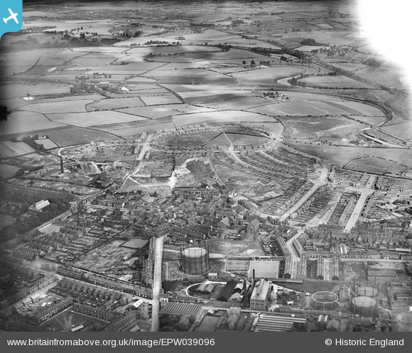
EPW039096 ENGLAND (1932). New housing estate under construction, East Moor, 1932
© Hawlfraint cyfranwyr OpenStreetMap a thrwyddedwyd gan yr OpenStreetMap Foundation. 2024. Trwyddedir y gartograffeg fel CC BY-SA.
Delweddau cyfagos (3)
EPW039096

EPW039097

EPW039101

Manylion
| Pennawd | [EPW039096] New housing estate under construction, East Moor, 1932 |
| Cyfeirnod | EPW039096 |
| Dyddiad | July-1932 |
| Dolen | |
| Enw lle | EAST MOOR |
| Plwyf | |
| Ardal | |
| Gwlad | ENGLAND |
| Dwyreiniad / Gogleddiad | 434150, 421282 |
| Hydred / Lledred | -1.4828436821322, 53.686646375288 |
| Cyfeirnod Grid Cenedlaethol | SE342213 |
Pinnau
 drj |
Sunday 3rd of January 2021 09:27:37 PM | |
drj |
Sunday 3rd of January 2021 09:25:47 PM | |
drj |
Sunday 3rd of January 2021 09:23:13 PM | |
trevorsboy |
Tuesday 15th of March 2016 07:52:57 PM | |
trevorsboy |
Tuesday 15th of March 2016 07:52:04 PM | |
trevorsboy |
Tuesday 15th of March 2016 07:50:08 PM | |
trevorsboy |
Tuesday 15th of March 2016 07:49:07 PM | |
Sue |
Tuesday 28th of April 2015 08:54:54 PM |
Cyfraniadau Grŵp
This photo shows the Wind Hill and Mount Clay brickworks. I have referenced it here: http://www.bagnallancestry.co.uk/places/bagnall_bricks.asp Many thanks! |
 GusTButt |
Friday 7th of February 2014 04:34:01 PM |


