
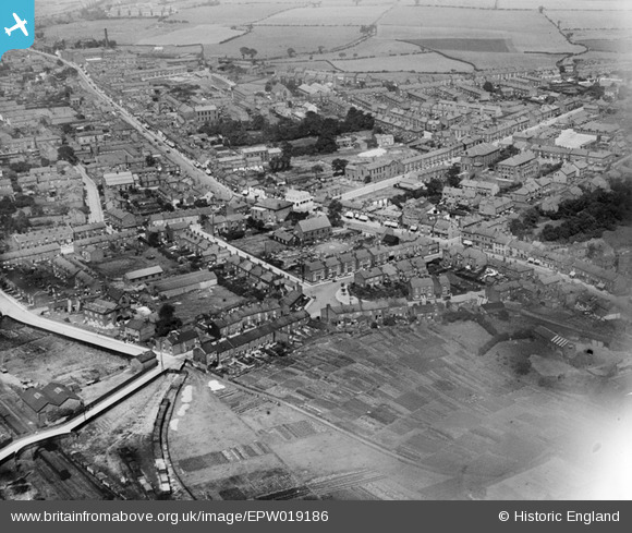
EPW019186 ENGLAND (1927). London Road and environs, Hazel Grove, 1927
© Hawlfraint cyfranwyr OpenStreetMap a thrwyddedwyd gan yr OpenStreetMap Foundation. 2024. Trwyddedir y gartograffeg fel CC BY-SA.
Delweddau cyfagos (3)
EPW019186

EAW043350

EPW019187

Manylion
| Pennawd | [EPW019186] London Road and environs, Hazel Grove, 1927 |
| Cyfeirnod | EPW019186 |
| Dyddiad | August-1927 |
| Dolen | |
| Enw lle | HAZEL GROVE |
| Plwyf | |
| Ardal | |
| Gwlad | ENGLAND |
| Dwyreiniad / Gogleddiad | 392078, 386918 |
| Hydred / Lledred | -2.1191007328041, 53.378791199397 |
| Cyfeirnod Grid Cenedlaethol | SJ921869 |
Pinnau
 Steve |
Thursday 1st of October 2020 06:55:19 AM | |
Steve T |
Tuesday 26th of June 2018 11:54:13 PM | |
TSG |
Wednesday 15th of July 2015 01:00:44 PM | |
neilds21 |
Monday 28th of April 2014 05:15:13 PM | |
neilds21 |
Monday 28th of April 2014 05:14:03 PM | |
John Ellis |
Friday 25th of January 2013 10:56:21 PM | |
John Ellis |
Friday 7th of December 2012 10:45:52 PM | |
John Ellis |
Friday 7th of December 2012 10:44:56 PM | |
John Ellis |
Friday 7th of December 2012 10:41:03 PM | |
John Ellis |
Friday 7th of December 2012 10:40:07 PM | |
John Ellis |
Friday 7th of December 2012 10:39:31 PM | |
John Ellis |
Friday 7th of December 2012 10:38:17 PM | |
John Ellis |
Friday 7th of December 2012 10:37:23 PM | |
John Ellis |
Friday 7th of December 2012 10:36:42 PM | |
John Ellis |
Friday 7th of December 2012 10:36:03 PM | |
John Ellis |
Friday 7th of December 2012 10:35:26 PM | |
John Ellis |
Friday 7th of December 2012 10:34:00 PM | |
John Ellis |
Friday 7th of December 2012 10:31:06 PM | |
Lee Allsopp |
Thursday 12th of July 2012 01:13:01 PM | |
Hi Lee I've just been looking at this aerial view photograph of Hazel Grove which is really interesting. You've tagged this area as New Fold Farm - I have heard of Old Fold Farm and wondered if this is the same one that you mean? If not, do you know where Old Fold Farm is on this photo? Thank you |
el.h |
Sunday 27th of March 2016 06:13:28 PM |
Lee Allsopp |
Thursday 12th of July 2012 01:11:25 PM | |
Lee Allsopp |
Thursday 12th of July 2012 01:10:09 PM | |
Lee Allsopp |
Thursday 12th of July 2012 01:08:07 PM | |
Lee Allsopp |
Thursday 12th of July 2012 01:07:07 PM | |
Lee Allsopp |
Thursday 12th of July 2012 01:04:00 PM | |
Lee Allsopp |
Thursday 12th of July 2012 01:02:42 PM | |
Lee Allsopp |
Thursday 12th of July 2012 01:01:51 PM | |
Lee Allsopp |
Thursday 12th of July 2012 01:00:52 PM | |
Lee Allsopp |
Thursday 12th of July 2012 12:59:46 PM | |
Lee Allsopp |
Thursday 12th of July 2012 12:58:50 PM | |
Lee Allsopp |
Thursday 12th of July 2012 12:56:50 PM | |
Lee Allsopp |
Thursday 12th of July 2012 12:56:00 PM | |
Lee Allsopp |
Thursday 12th of July 2012 12:54:15 PM |


