
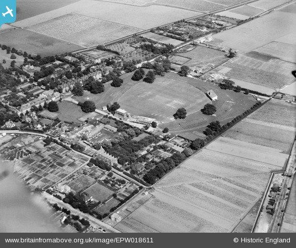
EPW018611 ENGLAND (1927). Cricket match in progress at the County Cricket Ground (St Lawrence Ground), Canterbury, 1927
© Hawlfraint cyfranwyr OpenStreetMap a thrwyddedwyd gan yr OpenStreetMap Foundation. 2024. Trwyddedir y gartograffeg fel CC BY-SA.
Delweddau cyfagos (13)
EPW018611
, Canterbury, 1927")
EAW014339
, Canterbury, 1948. This image has been produced from a print.")
EAW031805

EAW031806

EAW031807

EAW014337
, Canterbury, 1948. This image has been produced from a print.")
EAW014338
, Canterbury, 1948. This image has been produced from a print.")
EPW018613
, Canterbury, 1927")
EPW018614
, Canterbury, 1927")
EPW038145

EPW018610
, Canterbury, 1927")
EAW014341
, Canterbury, from the north-east, 1948. This image has been produced from a print.")
EAW014340
, Canterbury, from the south-east, 1948. This image has been produced from a print.")
Manylion
| Pennawd | [EPW018611] Cricket match in progress at the County Cricket Ground (St Lawrence Ground), Canterbury, 1927 |
| Cyfeirnod | EPW018611 |
| Dyddiad | 22-June-1927 |
| Dolen | |
| Enw lle | CANTERBURY |
| Plwyf | |
| Ardal | |
| Gwlad | ENGLAND |
| Dwyreiniad / Gogleddiad | 615706, 156596 |
| Hydred / Lledred | 1.092475099811, 51.267121143263 |
| Cyfeirnod Grid Cenedlaethol | TR157566 |
Pinnau
 MB |
Saturday 12th of January 2013 10:35:14 AM | |
MB |
Saturday 12th of January 2013 10:34:54 AM | |
MB |
Saturday 12th of January 2013 10:30:30 AM | |
MB |
Saturday 12th of January 2013 10:28:24 AM | |
Paolo |
Saturday 10th of November 2012 05:00:59 PM | |
Paolo |
Saturday 10th of November 2012 04:55:51 PM | |
knight2000 |
Friday 12th of October 2012 07:05:17 PM |
Cyfraniadau Grŵp
Details of the St Lawrence ground exist on Wikipedia - see en.wikipedia.org/wiki/St_Lawrence_Ground |
MB |
Saturday 12th of January 2013 10:29:58 AM |


