
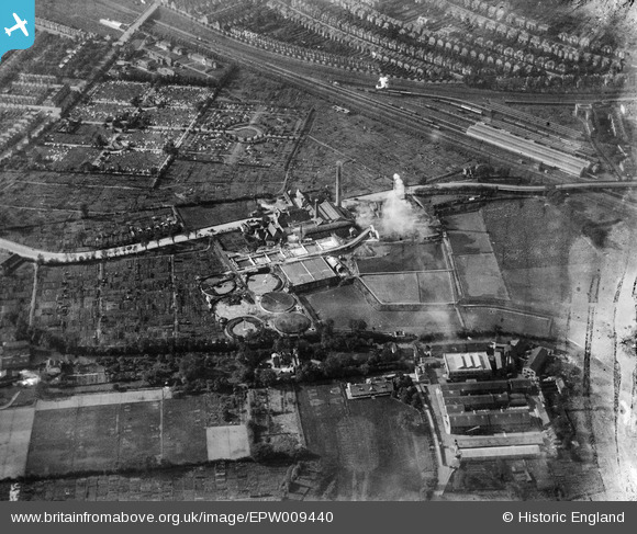
EPW009440 ENGLAND (1923). The Sewage Works, Wimbledon, 1923
© Hawlfraint cyfranwyr OpenStreetMap a thrwyddedwyd gan yr OpenStreetMap Foundation. 2024. Trwyddedir y gartograffeg fel CC BY-SA.
Delweddau cyfagos (3)
EPW009440

EPW009437

EPW009438

Manylion
| Pennawd | [EPW009440] The Sewage Works, Wimbledon, 1923 |
| Cyfeirnod | EPW009440 |
| Dyddiad | 1923 |
| Dolen | |
| Enw lle | WIMBLEDON |
| Plwyf | |
| Ardal | |
| Gwlad | ENGLAND |
| Dwyreiniad / Gogleddiad | 525774, 171807 |
| Hydred / Lledred | -0.19052551672139, 51.430797307989 |
| Cyfeirnod Grid Cenedlaethol | TQ258718 |
Pinnau
 Hon Sec |
Saturday 25th of February 2017 04:35:35 PM | |
chris_uk10 |
Saturday 4th of April 2015 04:59:18 PM | |
EC3Don |
Tuesday 7th of October 2014 12:24:02 PM | |
kjc |
Thursday 2nd of October 2014 09:44:20 AM | |
kjc |
Thursday 2nd of October 2014 09:44:00 AM | |
kjc |
Thursday 2nd of October 2014 09:40:02 AM |
Cyfraniadau Grŵp
Wimbledon Sewage Works was located between the banks of the River Wandle to the east and Durnsford Road to the west. It closed in the mid 1950's. |
kjc |
Thursday 2nd of October 2014 09:43:27 AM |
Durnsford Road runs across the middle. Gap Road cemetery beyond and in the distance is the main line. |
alany |
Wednesday 19th of March 2014 10:38:59 AM |


