
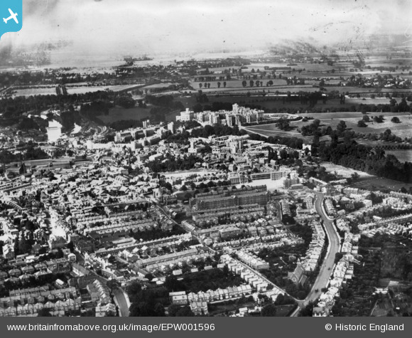
EPW001596 ENGLAND (1920). The castle and town, Windsor, from the south-west, 1920. This image has been produced from a print.
© Hawlfraint cyfranwyr OpenStreetMap a thrwyddedwyd gan yr OpenStreetMap Foundation. 2024. Trwyddedir y gartograffeg fel CC BY-SA.
Delweddau cyfagos (4)
EPW001596

EPW022610

EAW052998

EPW022604

Manylion
| Pennawd | [EPW001596] The castle and town, Windsor, from the south-west, 1920. This image has been produced from a print. |
| Cyfeirnod | EPW001596 |
| Dyddiad | June-1920 |
| Dolen | |
| Enw lle | WINDSOR |
| Plwyf | |
| Ardal | |
| Gwlad | ENGLAND |
| Dwyreiniad / Gogleddiad | 496563, 176264 |
| Hydred / Lledred | -0.60940571836739, 51.476598159885 |
| Cyfeirnod Grid Cenedlaethol | SU966763 |
Pinnau
 Popsety |
Saturday 14th of January 2023 12:23:18 PM | |
Thamesweb |
Wednesday 12th of November 2014 04:44:59 PM | |
Thamesweb |
Wednesday 12th of November 2014 04:41:58 PM |
Cyfraniadau Grŵp
 Windsor and Eaton Central Railway Station |
 Alan McFaden |
Wednesday 12th of November 2014 05:52:08 PM |
 Windsor And Eton Riverside Railway Station |
Alan McFaden |
Wednesday 12th of November 2014 05:50:58 PM |
 Windsor Castle |
Alan McFaden |
Wednesday 12th of November 2014 05:50:14 PM |


