
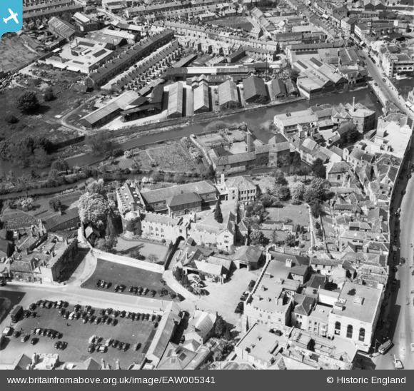
EAW005341 ENGLAND (1947). The remains of Taunton Castle, Taunton, 1947
© Hawlfraint cyfranwyr OpenStreetMap a thrwyddedwyd gan yr OpenStreetMap Foundation. 2024. Trwyddedir y gartograffeg fel CC BY-SA.
Delweddau cyfagos (31)
EAW005341

EAW005337

EAW005339

EAW005340

EAW005338

EAW005342

EPW041183

EPW041094

EPW041184

EPW041093

EPW027886

EPW041182

EAW051943

EPW013543

EAW051944

EPW013541

EAW049103

EAW005346

EAW005347

EAW051947

EAW051948

EPW027895

EPW027899

EPW041181

EPW027885

EPW027893

EAW051946

EPW027897

EAW049104

EAW051941

EAW015037

Manylion
| Pennawd | [EAW005341] The remains of Taunton Castle, Taunton, 1947 |
| Cyfeirnod | EAW005341 |
| Dyddiad | 13-May-1947 |
| Dolen | |
| Enw lle | TAUNTON |
| Plwyf | |
| Ardal | |
| Gwlad | ENGLAND |
| Dwyreiniad / Gogleddiad | 322606, 124645 |
| Hydred / Lledred | -3.10344221359, 51.01542908398 |
| Cyfeirnod Grid Cenedlaethol | ST226246 |
Pinnau
 Somerset Chick |
Saturday 18th of March 2017 10:56:54 PM | |
Somerset Chick |
Saturday 18th of March 2017 10:56:04 PM | |
MB |
Wednesday 6th of November 2013 04:05:50 PM | |
MB |
Wednesday 6th of November 2013 04:04:21 PM | |
MB |
Wednesday 6th of November 2013 04:03:56 PM | |
MB |
Wednesday 6th of November 2013 04:03:40 PM | |
MB |
Wednesday 6th of November 2013 04:02:54 PM | |
MB |
Wednesday 6th of November 2013 04:02:31 PM |


