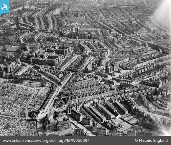
epw056664 ENGLAND (1938). Dartmouth Park Hill and environs, Upper Holloway, 1938
© Copyright OpenStreetMap contributors and licensed by the OpenStreetMap Foundation. 2026. Cartography is licensed as CC BY-SA.
Details
| Title | [EPW056664] Dartmouth Park Hill and environs, Upper Holloway, 1938 |
| Reference | EPW056664 |
| Date | 30-March-1938 |
| Link | |
| Place name | UPPER HOLLOWAY |
| Parish | |
| District | |
| Country | ENGLAND |
| Easting / Northing | 528986, 186728 |
| Longitude / Latitude | -0.13888557582955, 51.564181741697 |
| National Grid Reference | TQ290867 |
Pins

Mickeygo |
Wednesday 20th of August 2025 04:45:47 PM | |
|
carolyn |
Wednesday 6th of December 2023 02:18:59 PM | |
|
Lady D. |
Wednesday 19th of July 2023 09:15:05 AM | |
|
Lady D. |
Wednesday 19th of July 2023 09:10:46 AM | |
|
Lady D. |
Wednesday 19th of July 2023 08:57:31 AM | |
|
Lady D. |
Wednesday 19th of July 2023 08:56:23 AM | |
|
lesleyhoskins |
Monday 24th of February 2020 10:49:16 PM | |
|
Nowy Paul |
Sunday 15th of April 2018 03:02:34 PM | |
 |
iView |
Tuesday 14th of March 2017 06:42:36 PM |

Class31 |
Wednesday 17th of December 2014 12:33:38 PM | |
|
billyfern |
Friday 27th of June 2014 10:07:53 AM | |
|
billyfern |
Friday 27th of June 2014 10:05:16 AM | |
|
billyfern |
Friday 27th of June 2014 10:03:00 AM | |
|
billyfern |
Friday 27th of June 2014 10:01:44 AM | |
|
billyfern |
Friday 27th of June 2014 10:00:09 AM | |
|
billyfern |
Friday 27th of June 2014 09:58:22 AM | |
|
JulianN19 |
Sunday 20th of April 2014 02:32:02 PM | |
|
Coventry kid |
Saturday 9th of November 2013 05:51:35 PM | |
|
Coventry kid |
Saturday 9th of November 2013 05:47:59 PM | |
|
Coventry kid |
Saturday 9th of November 2013 05:46:27 PM | |
|
bugbear |
Wednesday 14th of August 2013 03:38:42 PM | |
|
bugbear |
Wednesday 14th of August 2013 03:25:17 PM |