
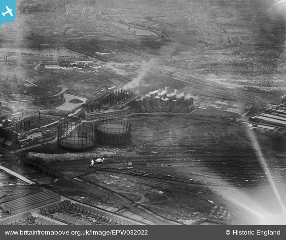
epw032022 ENGLAND (1930). Heartlands Street Gas Works and environs, Nechells, 1930
© Copyright OpenStreetMap contributors and licensed by the OpenStreetMap Foundation. 2026. Cartography is licensed as CC BY-SA.
Details
| Title | [EPW032022] Heartlands Street Gas Works and environs, Nechells, 1930 |
| Reference | EPW032022 |
| Date | May-1930 |
| Link | |
| Place name | NECHELLS |
| Parish | |
| District | |
| Country | ENGLAND |
| Easting / Northing | 409858, 289472 |
| Longitude / Latitude | -1.8547568133115, 52.502691953317 |
| National Grid Reference | SP099895 |
Pins

stevebirch |
Wednesday 19th of February 2014 01:25:34 AM | |
|
PURCELL |
Sunday 17th of November 2013 06:03:28 PM | |
|
JM |
Friday 26th of October 2012 04:39:47 PM | |
|
JM |
Friday 26th of October 2012 04:39:13 PM | |
|
JM |
Friday 26th of October 2012 04:38:18 PM |
User Comment Contributions
The smaller power station to the left of the gasometers was the Temporary Power Station,erected during the First World War,to meet the electrical demand of nearby munitions factories.Construction of Nechells (Princes) Power Station (above the gasometers) had been stopped by the Government upon the outbreak of the war.All the cooling towers were of wooden construction. |
Laurie_B |
Tuesday 20th of November 2012 12:44:12 PM |
The gas holders are still there - beside the A47 on what is now Heartlands Parkway. And the smoking chimneys are now Costco |
JM |
Tuesday 23rd of October 2012 10:37:51 AM |