
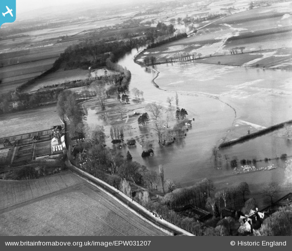
epw031207 ENGLAND (1929). The River Thames flood at Ruddle's Pool, Windsor, from the south-east, 1929
© Copyright OpenStreetMap contributors and licensed by the OpenStreetMap Foundation. 2026. Cartography is licensed as CC BY-SA.
Details
| Title | [EPW031207] The River Thames flood at Ruddle's Pool, Windsor, from the south-east, 1929 |
| Reference | EPW031207 |
| Date | December-1929 |
| Link | |
| Place name | WINDSOR |
| Parish | |
| District | |
| Country | ENGLAND |
| Easting / Northing | 493615, 177107 |
| Longitude / Latitude | -0.65162323363065, 51.484672414653 |
| National Grid Reference | SU936771 |
Pins
  Maidenhead Road (Surly Hall Road) later realigned to the south beyond The Willows and bypassing Bullocks Hatch Bridge.
My photograph shows the road immediately west of ‘The Willows’ looking towards Bullocks Hatch Bridge. A marina is now located to the right of this view. Maidenhead Road (Surly Hall Road) later realigned to the south beyond The Willows and bypassing Bullocks Hatch Bridge.
My photograph shows the road immediately west of ‘The Willows’ looking towards Bullocks Hatch Bridge. A marina is now located to the right of this view. |

Thamesweb |
Friday 1st of January 2016 12:17:40 PM |
| Location of future Dorney Rowing Lake |
Thamesweb |
Friday 1st of January 2016 12:09:00 PM |
| Approximate site of The Fishery |
Thamesweb |
Friday 1st of January 2016 12:07:58 PM |
| Original walled garden later to be demolished to become a garden centre. Possibly area for housing development in the 2020s |
Thamesweb |
Friday 1st of January 2016 12:06:41 PM |
| The Willows |
Thamesweb |
Friday 1st of January 2016 12:04:43 PM |