
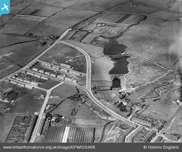
epw016468 ENGLAND (1926). The reservoirs at Little Green, Middleton, 1926
© Copyright OpenStreetMap contributors and licensed by the OpenStreetMap Foundation. 2025. Cartography is licensed as CC BY-SA.
Details
| Title | [EPW016468] The reservoirs at Little Green, Middleton, 1926 |
| Reference | EPW016468 |
| Date | 6-August-1926 |
| Link | |
| Place name | MIDDLETON |
| Parish | |
| District | |
| Country | ENGLAND |
| Easting / Northing | 388021, 406571 |
| Longitude / Latitude | -2.1808434484837, 53.555384761806 |
| National Grid Reference | SD880066 |
Pins

Us |
Wednesday 8th of May 2013 10:19:32 PM | |
|
Us |
Wednesday 8th of May 2013 10:15:25 PM | |
|
Us |
Wednesday 8th of May 2013 10:15:25 PM | |

Class31 |
Monday 21st of January 2013 09:16:44 AM | |
|
Class31 |
Monday 21st of January 2013 09:15:59 AM | |
|
Class31 |
Monday 21st of January 2013 09:13:44 AM | |
|
Class31 |
Monday 21st of January 2013 09:13:28 AM | |
|
Class31 |
Monday 21st of January 2013 09:12:52 AM | |
|
Class31 |
Monday 21st of January 2013 09:12:27 AM | |
|
Class31 |
Monday 21st of January 2013 09:11:31 AM | |
|
Geoff Wellens |
Friday 19th of October 2012 07:58:22 PM | |
|
Geoff Wellens |
Friday 19th of October 2012 07:53:41 PM | |
|
Al Roach |
Monday 16th of July 2012 01:33:41 PM | |
|
Al Roach |
Sunday 15th of July 2012 10:13:00 PM | |
Boarshaw Cemetery was created in 1912 and was known as the New Cemetery to distinguish it from the cemetery near Middleton Parish Church, now "The Old Cemetery". |
Geoff Wellens |
Friday 19th of October 2012 07:53:00 PM |