
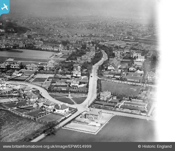
epw014999 ENGLAND (1926). Prenton, Birkenhead, from the south-west, 1926
© Copyright OpenStreetMap contributors and licensed by the OpenStreetMap Foundation. 2026. Cartography is licensed as CC BY-SA.
Details
| Title | [EPW014999] Prenton, Birkenhead, from the south-west, 1926 |
| Reference | EPW014999 |
| Date | 12-April-1926 |
| Link | |
| Place name | BIRKENHEAD |
| Parish | |
| District | |
| Country | ENGLAND |
| Easting / Northing | 330656, 386175 |
| Longitude / Latitude | -3.0422733902296, 53.367621038001 |
| National Grid Reference | SJ307862 |
Pins

XMAS DAY |
Sunday 26th of April 2026 10:44:50 AM | |
|
XMAS DAY |
Sunday 26th of April 2026 07:48:46 AM | |
|
nemo20000 |
Sunday 5th of June 2022 03:36:05 PM | |
|
optikc |
Sunday 28th of June 2020 02:28:28 PM | |
|
optikc |
Sunday 28th of June 2020 02:25:41 PM | |
|
optikc |
Sunday 28th of June 2020 02:22:04 PM | |
|
optikc |
Sunday 28th of June 2020 02:20:07 PM | |
|
optikc |
Sunday 28th of June 2020 02:18:04 PM | |
|
TonyBirkenhead |
Thursday 20th of February 2020 01:32:30 PM | |
|
Bradley100 |
Tuesday 7th of June 2016 11:43:12 AM | |
|
Bradley100 |
Tuesday 7th of June 2016 11:43:11 AM | |
|
gBr |
Sunday 3rd of August 2014 07:01:26 PM | |
|
kinmel |
Sunday 1st of September 2013 05:31:21 PM | |
|
kinmel |
Sunday 1st of September 2013 05:30:48 PM | |
|
kinmel |
Sunday 1st of September 2013 05:30:01 PM | |
|
kinmel |
Sunday 1st of September 2013 05:29:14 PM | |
|
HydeParkDave |
Monday 16th of July 2012 11:34:41 PM | |
|
Dave T |
Friday 13th of July 2012 03:17:33 PM | |
Seems unlikely. Construction started on Battersea Power Station in 1929. Could be factory chimneys. |
Tony D |
Friday 13th of July 2012 05:17:06 PM |
It's certainly not Battersea... I am very doubtful about it being London. |
Survey of London historian |
Tuesday 31st of July 2012 06:37:38 PM |
The location has been found - in Prenton, Merseyside |
Trebor |
Tuesday 28th of August 2012 11:26:26 AM |
|
Dave T |
Friday 13th of July 2012 03:08:49 PM | |
|
Dave T |
Friday 13th of July 2012 03:06:47 PM | |
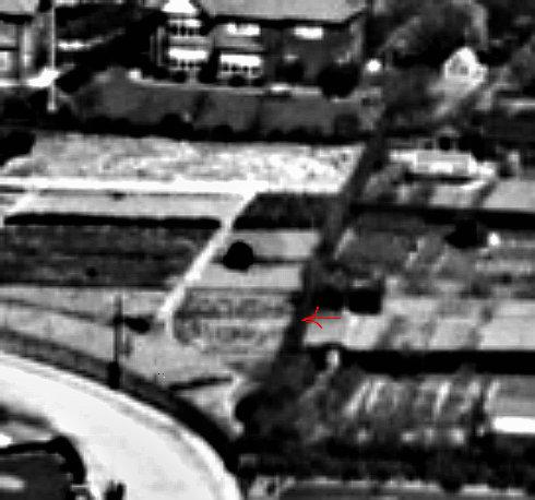
Allotment Gardens |
Pete65 |
Monday 25th of March 2013 12:14:31 PM |

Angiekav |
Sunday 8th of July 2012 10:51:52 PM | |
St Stephens C of E Church |
Pete65 |
Monday 25th of March 2013 12:12:56 PM |
St Stephen's Church Prenton was where my wife and I married in 1971 and where our three children were all christened. |
Robbied |
Tuesday 3rd of March 2015 10:16:49 PM |
|
EastMarple1 |
Saturday 30th of June 2012 11:58:57 AM | |
|
BigglesH |
Tuesday 26th of June 2012 04:43:48 PM | |
Biggles - the location - no longer in question - Prenton, near Birkenhead on the Wirral. Categorically that is a War Memorial. Photo was taken at time of massive housing development of the area... |
Pete65 |
Monday 14th of October 2013 11:06:58 AM |
User Comment Contributions
This area of superior suburban housing was hit heavily by German bombing in WW2 - possibly by inaccurate attacks aimed (badly) at Birkenheads dock installations - or maybe accurate attacks on the nearby reservoir (See - Reservoir Road North) |
Pete65 |
Monday 25th of March 2013 12:12:01 PM |
Ah, so it was a river at the top, just the Mersey, not the Thames! Nice one Trebor. |
Dave T |
Thursday 22nd of November 2012 03:37:25 PM |
There is absolutely no doubt that this pic is of Prenton, Merseyside from the SW and looking towards Tranmere Rovers football ground. The road junction is between Osmaston Rd and Prenton Lane. Input the area in Google Maps. |
Trebor |
Tuesday 23rd of October 2012 03:14:25 PM |
Hi Trebor, Thanks very much for your identification, we can update the catalogue and post the correct location information here in due course. You may be interested to know that the original Aerofilm's Ltd Register entry for this image is "Haunchwood Brick and Tile, Griff Yard, Nuneaton", so it's no wonder we couldn't identify the photo. Yours, Katy Britain from Above Cataloguing Team Leader |
Katy Whitaker |
Tuesday 23rd of October 2012 03:14:25 PM |
This is Prenton, Birkenhead. It is indeed a War Memorial in the foreground. Running top to bottom is Prenton Lane and to the left Osmaston Road. The Church is St Stephens. |
Dr Bob |
Wednesday 3rd of October 2012 11:19:18 AM |
@Trebor - thanks. No, I used a few bits of information, in particular the angle of the sun, implying that the view was northerly towards a river or estuary in the distance. The road layout and the memorial in the foreground was matched more by luck. |
davidsw16 |
Thursday 20th of September 2012 08:59:53 PM |
This is Prenton in Merseyside looking towards Birkenhead. The junction in the foreground is Osmaston Road where it meets Prenton Lane. |
davidsw16 |
Tuesday 28th of August 2012 11:28:51 AM |
Well done David! Do you live in the area? I checked on Google Maps - spot on! |
Trebor |
Tuesday 28th of August 2012 11:28:51 AM |
It probably is a trick of light but it looks like words in the field left of the cross. |
Iwanttogothere |
Saturday 14th of July 2012 04:32:43 PM |
On the (then) edge of a City (Birmingham or Coventry ?) |
BigglesH |
Tuesday 26th of June 2012 05:07:31 PM |