
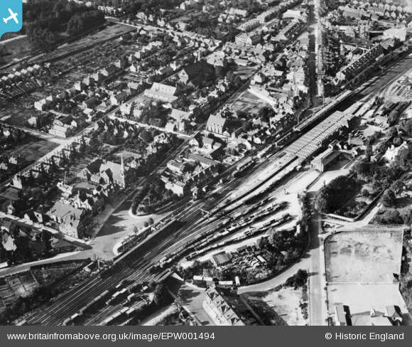
epw001494 ENGLAND (1920). The Railway Station and Commercial Road, Woking, 1920. This image has been produced from a copy-negative.
© Copyright OpenStreetMap contributors and licensed by the OpenStreetMap Foundation. 2026. Cartography is licensed as CC BY-SA.
Details
| Title | [EPW001494] The Railway Station and Commercial Road, Woking, 1920. This image has been produced from a copy-negative. |
| Reference | EPW001494 |
| Date | June-1920 |
| Link | |
| Place name | WOKING |
| Parish | |
| District | |
| Country | ENGLAND |
| Easting / Northing | 500520, 158673 |
| Longitude / Latitude | -0.55742426342674, 51.31776911206 |
| National Grid Reference | TQ005587 |
Pins

Josh |
Wednesday 9th of August 2017 10:00:39 PM | |
|
David960 |
Sunday 11th of June 2017 11:17:39 AM | |
|
David960 |
Sunday 11th of June 2017 11:16:22 AM | |
|
David960 |
Sunday 11th of June 2017 11:13:59 AM | |
|
David960 |
Sunday 11th of June 2017 11:13:32 AM | |
|
Richard |
Tuesday 1st of November 2016 11:13:36 AM | |
|
Richard |
Tuesday 1st of November 2016 11:11:26 AM | |
|
Richard |
Tuesday 1st of November 2016 11:01:52 AM | |
|
RiverMilkman |
Wednesday 19th of October 2016 01:04:32 PM | |
|
RiverMilkman |
Wednesday 19th of October 2016 01:01:39 PM | |
|
RiverMilkman |
Wednesday 19th of October 2016 12:59:40 PM | |
|
David960 |
Tuesday 3rd of February 2015 06:59:23 PM | |
|
David960 |
Tuesday 3rd of February 2015 06:58:55 PM |