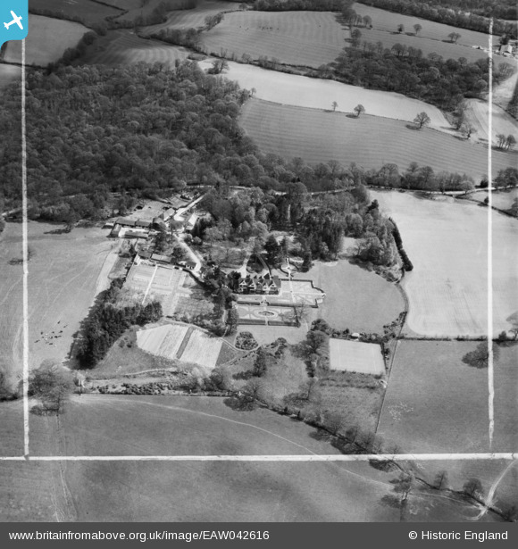
eaw042616 ENGLAND (1952). Gotwick Manor and Gotwick Manor Farm, Hammerwood, 1952. This image was marked by Aerofilms Ltd for photo editing.
© Copyright OpenStreetMap contributors and licensed by the OpenStreetMap Foundation. 2025. Cartography is licensed as CC BY-SA.
Nearby Images (11)
Details
| Title | [EAW042616] Gotwick Manor and Gotwick Manor Farm, Hammerwood, 1952. This image was marked by Aerofilms Ltd for photo editing. |
| Reference | EAW042616 |
| Date | 22-April-1952 |
| Link | |
| Place name | HAMMERWOOD |
| Parish | FOREST ROW |
| District | |
| Country | ENGLAND |
| Easting / Northing | 543000, 139766 |
| Longitude / Latitude | 0.044310216308498, 51.138756571141 |
| National Grid Reference | TQ430398 |
Pins
Be the first to add a comment to this image!


![[EAW042616] Gotwick Manor and Gotwick Manor Farm, Hammerwood, 1952. This image was marked by Aerofilms Ltd for photo editing.](http://britainfromabove.org.uk/sites/all/libraries/aerofilms-images/public/100x100/EAW/042/EAW042616.jpg)
![[EAW042618] Gotwick Manor and Gotwick Manor Farm, Hammerwood, 1952. This image was marked by Aerofilms Ltd for photo editing.](http://britainfromabove.org.uk/sites/all/libraries/aerofilms-images/public/100x100/EAW/042/EAW042618.jpg)
![[EAW042615] Gotwick Manor, Hammerwood, 1952. This image was marked by Aerofilms Ltd for photo editing.](http://britainfromabove.org.uk/sites/all/libraries/aerofilms-images/public/100x100/EAW/042/EAW042615.jpg)
![[EAW042611] Gotwick Manor, Hammerwood, 1952. This image has been produced from a print marked by Aerofilms Ltd for photo editing.](http://britainfromabove.org.uk/sites/all/libraries/aerofilms-images/public/100x100/EAW/042/EAW042611.jpg)
![[EAW042609] Gotwick Manor, Hammerwood, 1952. This image has been produced from a print marked by Aerofilms Ltd for photo editing.](http://britainfromabove.org.uk/sites/all/libraries/aerofilms-images/public/100x100/EAW/042/EAW042609.jpg)
![[EAW042612] Gotwick Manor, Hammerwood, 1952. This image has been produced from a print marked by Aerofilms Ltd for photo editing.](http://britainfromabove.org.uk/sites/all/libraries/aerofilms-images/public/100x100/EAW/042/EAW042612.jpg)
![[EAW042614] Gotwick Manor, Hammerwood, 1952. This image was marked by Aerofilms Ltd for photo editing.](http://britainfromabove.org.uk/sites/all/libraries/aerofilms-images/public/100x100/EAW/042/EAW042614.jpg)
![[EAW042613] Gotwick Manor, Hammerwood, 1952. This image was marked by Aerofilms Ltd for photo editing.](http://britainfromabove.org.uk/sites/all/libraries/aerofilms-images/public/100x100/EAW/042/EAW042613.jpg)
![[EAW042617] Gotwick Manor, Hammerwood, 1952. This image was marked by Aerofilms Ltd for photo editing.](http://britainfromabove.org.uk/sites/all/libraries/aerofilms-images/public/100x100/EAW/042/EAW042617.jpg)
![[EAW042619] Gotwick Manor and Gotwick Manor Farm, Hammerwood, 1952. This image was marked by Aerofilms Ltd for photo editing.](http://britainfromabove.org.uk/sites/all/libraries/aerofilms-images/public/100x100/EAW/042/EAW042619.jpg)
![[EAW042610] Gotwick Manor, Hammerwood, 1952. This image has been produced from a print marked by Aerofilms Ltd for photo editing.](http://britainfromabove.org.uk/sites/all/libraries/aerofilms-images/public/100x100/EAW/042/EAW042610.jpg)