
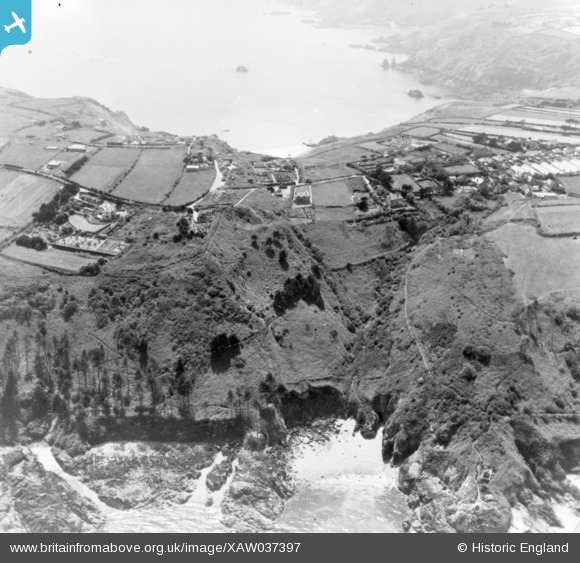
XAW037397 GUERNSEY (1951). Pied du Mur, Moulin Hurt and Boylet Column, Jerbourg, Guernsey, Guernsey, 1951. Oblique aerial photograph taken facing West.
© Copyright OpenStreetMap contributors and licensed by the OpenStreetMap Foundation. 2025. Cartography is licensed as CC BY-SA.
Nearby Images (4)
XAW037397

XPW043263

XAW037398

XAW037398DUP

Details
| Title | [XAW037397] Pied du Mur, Moulin Hurt and Boylet Column, Jerbourg, Guernsey, Guernsey, 1951. Oblique aerial photograph taken facing West. |
| Reference | XAW037397 |
| Date | 22-June-1951 |
| Link | |
| Place name | JERBOURG |
| Parish | GUERNSEY |
| District | |
| Country | GUERNSEY |
| Easting / Northing | 361342, -52443 |
| Longitude / Latitude | -2.534394, 49.427311 |
| National Grid Reference |
Pins
Be the first to add a comment to this image!
User Comment Contributions
Correction of placenames: (Moulin Hurt) - s/b Moulin Huet Bay (Boylet Column)- s/b Doyle Column: The column was erected to the memory of Sir John Doyle, Lt.-Governor of Guernsey from 1803-16. The photo shows the site of the original destroyed column (diamond-shaped area with debris near the end of the Jerbourg Road above Marble Bay), destroyed by the German Occupation Forces during WWII. The column has since been rebuilt in the same location. "Le Pied du Mur" is Marble Bay in English. |

Missamikery |
Thursday 7th of May 2015 07:40:04 PM |
Pied du Mur (Marble Bay) foreground, Doyle Column (remains)centre left, Jerbourg to left and Moulin Huet Bay top right. |
Josh' Paine |
Monday 13th of October 2014 12:21:13 PM |