
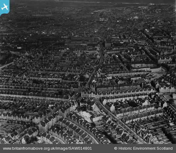
SAW014801 SCOTLAND (1948). Aberdeen, general view, showing Rosemount Place and Belgrave Terrace. An oblique aerial photograph taken facing east. This image has been produced from a print.
© Copyright OpenStreetMap contributors and licensed by the OpenStreetMap Foundation. 2025. Cartography is licensed as CC BY-SA.
Details
| Title | [SAW014801] Aberdeen, general view, showing Rosemount Place and Belgrave Terrace. An oblique aerial photograph taken facing east. This image has been produced from a print. |
| Reference | SAW014801 |
| Date | 1948 |
| Link | NRHE Collection item 1314727 |
| Place name | |
| Parish | ABERDEEN |
| District | CITY OF ABERDEEN |
| Country | SCOTLAND |
| Easting / Northing | 393132, 806618 |
| Longitude / Latitude | -2.1135273657903, 57.150575520963 |
| National Grid Reference | NJ931066 |
Pins

toonserjim |
Tuesday 29th of April 2014 07:52:46 PM | |
|
toonserjim |
Tuesday 29th of April 2014 07:51:04 PM | |
|
toonserjim |
Tuesday 29th of April 2014 07:48:46 PM | |
|
toonserjim |
Tuesday 29th of April 2014 07:47:58 PM | |
|
toonserjim |
Tuesday 29th of April 2014 07:47:14 PM | |
|
toonserjim |
Tuesday 29th of April 2014 07:45:34 PM | |
|
toonserjim |
Tuesday 29th of April 2014 07:44:52 PM | |
|
toonserjim |
Wednesday 12th of February 2014 09:15:41 PM | |
|
toonserjim |
Wednesday 12th of February 2014 09:14:21 PM | |
|
toonserjim |
Wednesday 12th of February 2014 09:13:15 PM | |
|
toonserjim |
Wednesday 12th of February 2014 09:12:46 PM | |
|
toonserjim |
Wednesday 12th of February 2014 09:12:13 PM | |
|
toonserjim |
Wednesday 12th of February 2014 09:11:37 PM |