
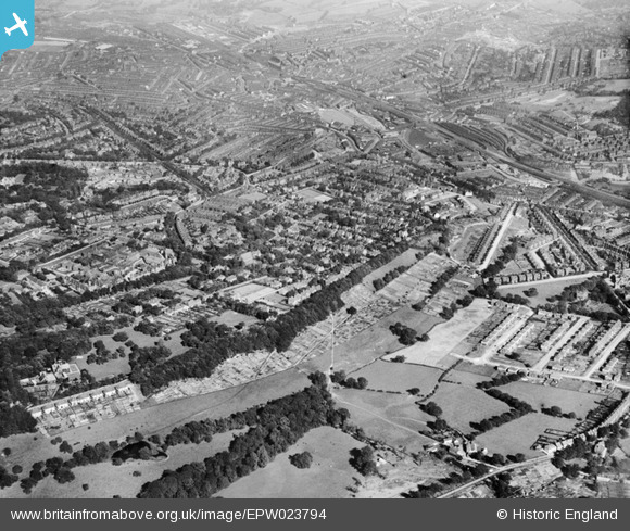
EPW023794 ENGLAND (1928). Nether Edge, Sheffield, 1928
© Copyright OpenStreetMap contributors and licensed by the OpenStreetMap Foundation. 2026. Cartography is licensed as CC BY-SA.
Details
| Title | [EPW023794] Nether Edge, Sheffield, 1928 |
| Reference | EPW023794 |
| Date | September-1928 |
| Link | |
| Place name | SHEFFIELD |
| Parish | |
| District | |
| Country | ENGLAND |
| Easting / Northing | 433851, 384615 |
| Longitude / Latitude | -1.4913352143233, 53.357063556095 |
| National Grid Reference | SK339846 |
Pins

Tom |
Friday 6th of September 2024 03:23:40 PM | |
|
Tom |
Friday 6th of September 2024 03:22:49 PM | |
|
richardegreen |
Sunday 2nd of May 2021 08:07:13 AM | |
|
Hunty |
Tuesday 16th of June 2020 12:23:09 PM | |
|
Deirdre Hodges |
Tuesday 7th of March 2017 06:03:27 PM | |
|
Deirdre Hodges |
Tuesday 7th of March 2017 05:57:21 PM | |
|
Ace |
Wednesday 11th of March 2015 07:06:43 PM | |
|
pod |
Thursday 24th of July 2014 12:50:38 PM | |
|
pod |
Thursday 24th of July 2014 12:48:06 PM | |
|
Sam |
Saturday 28th of September 2013 04:24:35 PM | |
|
Roob |
Monday 5th of November 2012 01:21:10 AM | |
|
Ace |
Tuesday 16th of October 2012 04:56:48 PM | |
Spent my 'apennyworth' of pocket money here. Also took back 'empties'to get a refund. |
Deirdre Hodges |
Tuesday 7th of March 2017 05:49:00 PM |
|
Ace |
Tuesday 16th of October 2012 04:55:52 PM | |
|
Ace |
Tuesday 16th of October 2012 04:55:12 PM | |
Once the home of Marples the smoothing plane manufacturer |
Ace |
Tuesday 16th of October 2012 05:04:38 PM |
|
Ace |
Tuesday 16th of October 2012 04:22:14 PM | |
|
JPW |
Friday 29th of June 2012 02:01:46 PM | |
|
richardegreen |
Tuesday 26th of June 2012 02:04:25 PM | |
limbrix |
Thursday 14th of June 2012 04:05:24 PM | |
|
limbrix |
Thursday 14th of June 2012 03:49:51 PM | |
|
limbrix |
Thursday 14th of June 2012 03:46:02 PM | |
This spot is actually the beginning of the present Knab Farm Estate. Glenorchy Road can be seen before the parallel Dalmore Road was built. I spent many hours on my bike (a few years after this photograph was taken) going round and round the 'Circle' linking Struan Road to Glenorchy Road. |
Deirdre Hodges |
Tuesday 7th of March 2017 06:02:29 PM |
|
limbrix |
Thursday 14th of June 2012 03:45:36 PM |

User Comment Contributions
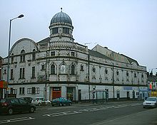
Abbeydale Picture House |
richardegreen |
Tuesday 26th of June 2012 02:02:00 PM |