
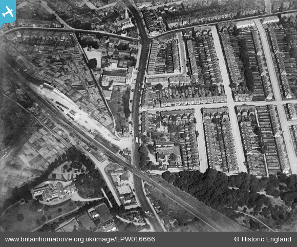
EPW016666 ENGLAND (1926). The station and Great North Road, East Finchley, 1926
© Copyright OpenStreetMap contributors and licensed by the OpenStreetMap Foundation. 2026. Cartography is licensed as CC BY-SA.
Nearby Images (3)
EPW016666

EPW016667

EPW016668

Details
| Title | [EPW016666] The station and Great North Road, East Finchley, 1926 |
| Reference | EPW016666 |
| Date | August-1926 |
| Link | |
| Place name | EAST FINCHLEY |
| Parish | |
| District | |
| Country | ENGLAND |
| Easting / Northing | 527297, 189254 |
| Longitude / Latitude | -0.16232663111, 51.587268681964 |
| National Grid Reference | TQ273893 |
Pins

finchleyguy |
Monday 4th of May 2015 06:47:03 PM | |
|
MLC |
Sunday 26th of April 2015 11:18:32 PM | |
|
MLC |
Sunday 26th of April 2015 11:14:54 PM | |
It was common practice to build temporary sidings to move in the large quantities of material requied to build the new housing about this time, so it was probably ripped back up before anyone got to map it. A further example is detailed by Maurice at Burnt Oak station in EPW016517 |
Dave Brunt |
Monday 27th of April 2015 04:57:27 PM |
|
MLC |
Sunday 26th of April 2015 10:53:18 PM | |
|
MLC |
Sunday 26th of April 2015 10:51:21 PM | |
|
SteveG63 |
Monday 8th of December 2014 11:15:48 PM | |
The church was East Finchley Congregational Church. It was a large Victorian gothic structure in its own grounds looking to me more like a C of E parish church. I believe it was replaced with the existing shops + flats in about the early 1970's. I know it was still there at the time of the Aberfan disaster in 1966. |
MLC |
Sunday 26th of April 2015 10:48:02 PM |
|
SteveG63 |
Monday 8th of December 2014 11:14:56 PM | |
|
David Morris |
Monday 7th of January 2013 11:42:29 AM | |
|
MB |
Saturday 6th of October 2012 08:06:09 PM | |
|
MB |
Saturday 6th of October 2012 08:05:17 PM | |
|
MB |
Saturday 6th of October 2012 08:04:51 PM |
